Alam Roza: Difference between revisions
Appearance
Content deleted Content added
Shyamsunder (talk | contribs) removed Category:Ahmedabad; added Category:Neighbourhoods in Ahmedabad using HotCat |
m Task 18 (cosmetic): eval 1 template: hyphenate params (1×); |
||
| (13 intermediate revisions by 9 users not shown) | |||
| Line 1: | Line 1: | ||
{{unreferenced|date=March 2012}} |
|||
{{More citations needed|date=October 2019}} |
|||
{{Infobox Indian jurisdiction |
|||
{{Use dmy dates|date=July 2018}} |
|||
| ⚫ | |||
{{Use Indian English|date=July 2018}} |
|||
| ⚫ | |||
{{Infobox settlement |
|||
| ⚫ | |||
| name = Alam Roza |
|||
| ⚫ | |||
| ⚫ | |||
| skyline = |
|||
| native_name_lang = |
|||
| skyline_alt = |
|||
| other_name = |
|||
| skyline_caption = |
|||
| nickname = |
|||
| area_total = |
|||
| ⚫ | |||
| area_magnitude = |
|||
| image_skyline = |
|||
| ⚫ | |||
| image_alt = |
|||
| area_total_cite = |
|||
| image_caption = |
|||
| area_metro = |
|||
| pushpin_map = India Ahmedabad |
|||
| area_metro_cite = |
|||
| pushpin_label_position = |
|||
| ⚫ | |||
| |
| pushpin_map_alt = |
||
| |
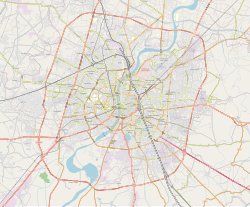
| pushpin_map_caption = Location in Ahmedabad, Gujarat, India |
||
| coordinates = {{Coord|22.994151|N|72.589361|E|display=inline,title}} |
|||
| ⚫ | |||
| |
| subdivision_type = Country |
||
| subdivision_name = {{flag|India}} |
|||
| subdivision_type1 = [[States and territories of India|State]] |
|||
| ⚫ | |||
| subdivision_type2 = [[List of districts of India|District]] |
|||
| ⚫ | |||
| established_title = <!-- Established --> |
|||
| established_date = |
|||
| founder = |
|||
| named_for = |
|||
| government_type = |
|||
| governing_body = [[Ahmedabad Municipal Corporation]] |
|||
| unit_pref = Metric |
|||
| area_footnotes = |
|||
| ⚫ | |||
| area_total_km2 = |
|||
| elevation_footnotes = |
|||
| elevation_m = |
|||
| population_total = |
|||
| population_as_of = |
|||
| population_rank = |
|||
| population_density_km2 = auto |
|||
| population_demonym = |
|||
| population_footnotes = |
|||
| demographics_type1 = Languages |
|||
| demographics1_title1 = Official |
|||
| demographics1_info1 = [[Gujarati language|Gujarati]], [[Hindi language|Hindi]] |
|||
| timezone1 = [[Indian Standard Time|IST]] |
|||
| utc_offset1 = +5:30 |
|||
| postal_code_type = [[Postal Index Number|PIN]] |
|||
| postal_code = 380028 |
|||
| area_code_type = Telephone code |
|||
| ⚫ | |||
| registration_plate =GJ |
|||
| blank1_name_sec1 = [[Lok Sabha]] constituency |
|||
| ⚫ | |||
| blank2_name_sec1 = Civic agency |
|||
| blank2_info_sec1 = [[Ahmedabad Municipal Corporation]] |
|||
| website = {{URL|gujaratindia.com}} |
|||
| footnotes = |
|||
}} |
}} |
||
'''Alam Roza''' is an area located in [[Ahmedabad]], [[India]]. |
'''Alam Roza''' is an area located in [[Ahmedabad]], [[India]].<ref>{{cite web |title=Pin Code: SHAH ALAM ROZA, AHMEDABAD, GUJARAT, India, Pincode.net.in |url=https://pincode.net.in/GUJARAT/AHMEDABAD/S/SHAH_ALAM_ROZA |website=pincode.net.in |access-date=22 October 2019}}</ref> |
||
| ⚫ | |||
==References== |
|||
{{coord missing|Gujarat}} |
|||
{{reflist}} |
|||
{{Ahmedabad}} |
|||
[[Category:Neighbourhoods in Ahmedabad]] |
[[Category:Neighbourhoods in Ahmedabad]] |
||
| ⚫ | |||
Latest revision as of 14:15, 15 January 2021
This article needs additional citations for verification. (October 2019) |
Alam Roza | |
|---|---|
Neighbourhood | |
| Coordinates: 22°59′39″N 72°35′22″E / 22.994151°N 72.589361°E | |
| Country | |
| State | Gujarat |
| District | Ahmedabad |
| Government | |
| • Body | Ahmedabad Municipal Corporation |
| Languages | |
| • Official | Gujarati, Hindi |
| Time zone | UTC+5:30 (IST) |
| PIN | 380028 |
| Telephone code | 91-079 |
| Vehicle registration | GJ |
| Lok Sabha constituency | Ahmedabad |
| Civic agency | Ahmedabad Municipal Corporation |
| Website | gujaratindia |
Alam Roza is an area located in Ahmedabad, India.[1]
References
[edit]- ^ "Pin Code: SHAH ALAM ROZA, AHMEDABAD, GUJARAT, India, Pincode.net.in". pincode.net.in. Retrieved 22 October 2019.

