Pacasmayo District: Difference between revisions
Appearance
Content deleted Content added
m Delink dates (WP:MOSUNLINKDATES) using AWB |
m fix image params |
||
| (12 intermediate revisions by 12 users not shown) | |||
| Line 1: | Line 1: | ||
{{Infobox |
{{Infobox settlement |
||
<!-- See Template:Infobox settlement for additional fields and descriptions --> |
|||
<!-- Basic info --> |
|||
| |
| name = Pacasmayo |
||
| native_name = |
|||
<!-- Images --> |
|||
| |
| native_name_lang = es<!-- ISO 639-2 code e.g. "es" for Spanish --> |
||
| |
| settlement_type = [[Districts of Peru|District]] |
||
| image_skyline =Pacasmayo 4.JPG |
|||
|image_size = |
|||
| image_alt = |
|||
|image_caption = |
|||
| |
| image_caption = Pacasmayo |
||
| image_flag = Bandera de pacasmayo.png |
|||
|coa_width = |
|||
| |
| flag_alt = |
||
| image_shield = Escudodepacasmayo.jpg |
|||
<!-- Location --> |
|||
| |
| shield_alt = |
||
| nickname = |
|||
| ⚫ | |||
| |
| image_map = |
||
| mapsize = frameless |
|||
|elevation = 8<!--Elevation in meters, without any formatting--> |
|||
| |
| map_alt = |
||
| map_caption = Location of Pacasmayo in the [[Pacasmayo Province|Pacasmayo]] province |
|||
| ⚫ | |||
| coordinates = {{coord|7|24|1|S|79|34|12|W|region:PE_type:adm3rd|display=inline,title}} |
|||
<!-- Area and population --> |
|||
| |
| coor_pinpoint = |
||
| coordinates_footnotes = |
|||
|density = {{commas|847.1}} |
|||
| subdivision_type = [[List of sovereign states|Country]] |
|||
| ⚫ | |||
| subdivision_name = {{flag|Peru}} |
|||
<!-- Politics --> |
|||
| |
| subdivision_type1 = [[Regions of Peru|Region]] |
||
| |
| subdivision_name1 = [[La Libertad Region|La Libertad]] |
||
| subdivision_type2 = [[Provinces of Peru|Province]] |
|||
<!-- Other --> |
|||
| ⚫ | |||
|web = <!--www.munipacasmayo.gob.pe--><!-- web address without the leading http:// --> |
|||
| parts_type = [[Subnational entity|Subdivisions]] |
|||
| parts_style = para |
|||
| p1 = |
|||
| established_title = Founded |
|||
| established_date = November 23, 1864 |
|||
| seat_type = [[Capital (political)|Capital]] |
|||
| seat = [[Pacasmayo]] |
|||
| leader_party = |
|||
| leader_title = [[Mayor]] |
|||
| leader_name = Cesar Rodolfo Milla Manay |
|||
| unit_pref = Metric<!-- or US or UK --> |
|||
| area_footnotes = |
|||
| ⚫ | |||
| area_note = |
|||
| elevation_footnotes = |
|||
| elevation_m = 8 |
|||
| population_footnotes = |
|||
| population_total = 28959 |
|||
| population_as_of = 2017 |
|||
| population_density_km2 = auto |
|||
| population_note = |
|||
| timezone1 = [[Time in Peru|PET]] |
|||
| utc_offset1 = -5 |
|||
| blank_name_sec1 = [[UBIGEO]] |
|||
| ⚫ | |||
| website = |
|||
| footnotes = |
|||
}} |
}} |
||
'''Pacasmayo District''' is one of five [[Districts of Peru|districts]] of the province [[Pacasmayo Province|Pacasmayo]] in [[Peru]].<ref>{{ |
'''Pacasmayo District''' is one of five [[Districts of Peru|districts]] of the province [[Pacasmayo Province|Pacasmayo]] in [[Peru]].<ref>{{in lang|es}} [[Instituto Nacional de Estadística e Informática]]. ''[http://desa.inei.gob.pe/mapas/bid/ Banco de Información Distrital] {{webarchive|url=https://web.archive.org/web/20080423164200/http://desa.inei.gob.pe/mapas/bid/ |date=2008-04-23 }}''. Retrieved April 11, 2008.</ref> It lies just over 100 km north of [[Trujillo, Peru|Trujillo]], in [[km]] number 681 from the [[Panamerican Highway]], is located in the coast beside to the [[Pacific Ocean]]. The city is visited commonly for [[surfers]]. |
||
<ref>http://www.perusurfguides.com/peru-surf-guides/surfing_peru_surf_peru_playas_pacasmayo.php Peru Surfing </ref> |
|||
==References== |
==References== |
||
{{Reflist}} |
{{Reflist}} |
||
{{Districts of Pacasmayo Province}} |
{{Districts of Pacasmayo Province}} |
||
{{coord|7.40027777778|S|79.57|W|source:dewiki_region:PE_type:city|format=dms|display=title}} |
|||
{{LaLibertad-geo-stub}} |
{{LaLibertad-geo-stub}} |
||
[[de:Pacasmayo]] |
|||
[[es:Distrito de Pacasmayo]] |
|||
[[eo:Pacasmayo]] |
|||
[[qu:Pakasmayu distritu]] |
|||
Latest revision as of 17:28, 2 March 2021
Pacasmayo | |
|---|---|
 Pacasmayo | |
 | |
| Coordinates: 7°24′1″S 79°34′12″W / 7.40028°S 79.57000°W | |
| Country | |
| Region | La Libertad |
| Province | Pacasmayo |
| Founded | November 23, 1864 |
| Capital | Pacasmayo |
| Government | |
| • Mayor | Cesar Rodolfo Milla Manay |
| Area | |
• Total | 30.84 km2 (11.91 sq mi) |
| Elevation | 8 m (26 ft) |
| Population (2017) | |
• Total | 28,959 |
| • Density | 940/km2 (2,400/sq mi) |
| Time zone | UTC-5 (PET) |
| UBIGEO | 130704 |
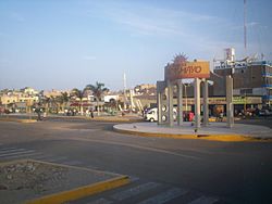
Pacasmayo District is one of five districts of the province Pacasmayo in Peru.[1] It lies just over 100 km north of Trujillo, in km number 681 from the Panamerican Highway, is located in the coast beside to the Pacific Ocean. The city is visited commonly for surfers. [2]
References
[edit]- ^ (in Spanish) Instituto Nacional de Estadística e Informática. Banco de Información Distrital Archived 2008-04-23 at the Wayback Machine. Retrieved April 11, 2008.
- ^ http://www.perusurfguides.com/peru-surf-guides/surfing_peru_surf_peru_playas_pacasmayo.php Peru Surfing


