Amt Seelow-Land: Difference between revisions
Appearance
Content deleted Content added
→Demography: Figures updated |
mNo edit summary |
||
| (2 intermediate revisions by 2 users not shown) | |||
| Line 4: | Line 4: | ||
#[[Falkenhagen]] |
#[[Falkenhagen]] |
||
#[[Fichtenhöhe]] |
#[[Fichtenhöhe]] |
||
#[[Gusow-Platkow]] |
|||
#[[Lietzen]] |
#[[Lietzen]] |
||
#[[Lindendorf]] |
#[[Lindendorf]] |
||
#[[Neuhardenberg]] |
|||
#[[Vierlinden]] |
#[[Vierlinden]] |
||
| Line 11: | Line 13: | ||
<gallery widths="250" heights="200"> |
<gallery widths="250" heights="200"> |
||
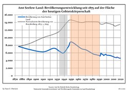
File:Bevölkerungsentwicklung Amt Seelow-Land.pdf|Development of Population since 1875 within the Current Boundaries (Blue Line: Population; Dotted Line: Comparison to Population Development of Brandenburg state; Grey Background: Time of Nazi rule; Red Background: Time of Communist rule) |
File:Bevölkerungsentwicklung Amt Seelow-Land.pdf|Development of Population since 1875 within the Current Boundaries (Blue Line: Population; Dotted Line: Comparison to Population Development of Brandenburg state; Grey Background: Time of Nazi rule; Red Background: Time of Communist rule) |
||
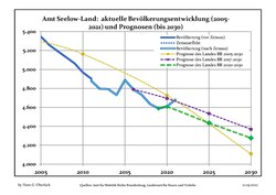
File:Bevölkerungsprognosen Amt Seelow-Land.pdf|Recent Population Development and Projections (Population Development before Census 2011 (blue line); Recent Population Development according to the [[Census in Germany]] in 2011 (blue bordered line); Official projections for 2005-2030 (yellow line); for |
File:Bevölkerungsprognosen Amt Seelow-Land.pdf|Recent Population Development and Projections (Population Development before Census 2011 (blue line); Recent Population Development according to the [[Census in Germany]] in 2011 (blue bordered line); Official projections for 2005-2030 (yellow line); for 2017-2030 (scarlet line); for 2020-2030 (green line) |
||
</gallery> |
</gallery> |
||
{{historical populations |
{{historical populations |
||
|align=none | cols=3 | percentages=pagr |
|align=none | cols=3 | percentages=pagr |
||
|title = Amt Seelow-Land: Population development <br>within the current boundaries ( |
|title = Amt Seelow-Land: Population development <br>within the current boundaries (2020)<ref>Detailed data sources are to be found in the Wikimedia Commons.[http://commons.wikimedia.org/wiki/Category:Population_projection_Brandenburg Population Projection Brandenburg at Wikimedia Commons]</ref> |
||
| 1875 | 7695 |
| 1875 | 7695 |
||
| 1890 | 6907 |
| 1890 | 6907 |
||
| 1910 | 6267 |
| 1910 | 6267 |
||
| 1925 | 7211 |
| 1925 | 7211 |
||
| 1933 | 6423 |
|||
| 1939 | 5988 |
| 1939 | 5988 |
||
| 1946 | 7715 |
|||
| 1950 | 8875 |
| 1950 | 8875 |
||
| 1964 | 7138 |
| 1964 | 7138 |
||
| Line 29: | Line 29: | ||
| 1981 | 5718 |
| 1981 | 5718 |
||
| 1985 | 5518 |
| 1985 | 5518 |
||
| 1989 | 5333 |
|||
| 1990 | 5271 |
| 1990 | 5271 |
||
| 1991 | 5189 |
|||
| 1992 | 5915 |
|||
| 1993 | 5675 |
|||
| 1994 | 5674 |
|||
| 1995 | 5548 |
| 1995 | 5548 |
||
| 1996 | 5314 |
|||
| 1997 | 5455 |
|||
| 1998 | 5551 |
|||
| 1999 | 5625 |
|||
| 2000 | 5429 |
| 2000 | 5429 |
||
| 2001 | 5368 |
|||
| 2002 | 5389 |
|||
| 2003 | 5362 |
|||
| 2004 | 5317 |
|||
| 2005 | 5346 |
| 2005 | 5346 |
||
| 2006 | 5258 |
|||
| 2007 | 5193 |
|||
| 2008 | 5129 |
|||
| 2009 | 5065 |
|||
| 2010 | 4968 |
| 2010 | 4968 |
||
| 2011 | 4878 |
|||
| 2012 | 4796 |
|||
| 2013 | 4793 |
|||
| 2014 | 4731 |
|||
| 2015 | 4888 |
| 2015 | 4888 |
||
| 2016 | 4790 |
| 2016 | 4790 |
||
| Line 60: | Line 39: | ||
| 2018 | 4634 |
| 2018 | 4634 |
||
| 2019 | 4588 |
| 2019 | 4588 |
||
| 2020 | 4609 |
|||
}} |
}} |
||
| ⚫ | |||
| ⚫ | |||
{{Ämter (Brandenburg)}} |
{{Ämter (Brandenburg)}} |
||
| ⚫ | |||
{{Authority control}} |
{{Authority control}} |
||
| ⚫ | |||
| ⚫ | |||
| ⚫ | |||
[[Category:Ämter in Brandenburg|Seelow-Land]] |
[[Category:Ämter in Brandenburg|Seelow-Land]] |
||
Latest revision as of 16:12, 15 March 2022
Amt Seelow-Land is an Amt ("collective municipality") in the district of Märkisch-Oderland, in Brandenburg, Germany. Its seat is in Seelow, itself not part of the Amt.
The Amt Seelow-Land consists of the following municipalities:
Demography
[edit]-
Development of Population since 1875 within the Current Boundaries (Blue Line: Population; Dotted Line: Comparison to Population Development of Brandenburg state; Grey Background: Time of Nazi rule; Red Background: Time of Communist rule)
-
Recent Population Development and Projections (Population Development before Census 2011 (blue line); Recent Population Development according to the Census in Germany in 2011 (blue bordered line); Official projections for 2005-2030 (yellow line); for 2017-2030 (scarlet line); for 2020-2030 (green line)
|
|
|
References
[edit]- ^ Detailed data sources are to be found in the Wikimedia Commons.Population Projection Brandenburg at Wikimedia Commons
52°32′03″N 14°22′55″E / 52.534167°N 14.382000°E


