Offenbach-Bieber: Difference between revisions
No edit summary |
Undid revision 1079385250 by 92.219.94.188 (talk) |
||
| (39 intermediate revisions by 30 users not shown) | |||
| Line 1: | Line 1: | ||
{{more citations needed|date=October 2021}} |
|||
[[Image:Karte Offenbach am Main in Deutschland.png|thumb|150px|location of Bieber in Germany]] |
|||
{{Infobox German location |
|||
| ⚫ | |||
|name = Bieber |
|||
| ⚫ | |||
|type = Stadtteil |
|||
| ⚫ | |||
|image_photo = Offenbach-Bieber Luftbild 004.jpg |
|||
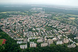
|image_caption = Aerial picture of Bieber from the west |
|||
|image_coa = WappenOffenbach-Bieber.png |
|||
| ⚫ | |||
|state = Hesse |
|||
|region = Darmstadt |
|||
|district = urban |
|||
|elevation = |
|||
|area = |
|||
|population = 16137 |
|||
|population_as_of = 2020-12-31 |
|||
|pop_ref = <ref name=pop>{{cite web|url=https://www.offenbach.de/medien/bindata/of/Statistik_und_wahlen_/dir-18/dir-29/BEV11-2020-Einwohnerstruktur-nach-Stadtteile-d_nd.pdf |title=2020-Einwohnerstruktur nach Stadtteilen deutsch/nichtdeutsch|publisher=Stadtverwaltung Offenbach|access-date=24 September 2021}}</ref> |
|||
|postal_code = 63073 |
|||
|area_code = 069 |
|||
|licence = |
|||
|website = |
|||
}} |
|||
| ⚫ | |||
| ⚫ | |||
| ⚫ | |||
| ⚫ | |||
== Geography == |
== Geography == |
||
A |
A small river, a tributary of the [[Rodau (Main)|Rodau]] called ''[[Bieber (Rodau)|Bieber]]'' flows through the village. |
||
| ⚫ | |||
| ⚫ | |||
== History == |
== History == |
||
| ⚫ | |||
| ⚫ | |||
| ⚫ | |||
Into the 19th century, Bieber's population was Roman Catholic. Now there is the catholic parish ''St. Nikolaus'' and a Protestant parish. |
|||
In 1938, the former municipality Bieber was merged with Offenbach. |
|||
==Infrastructure== |
|||
===Transport=== |
|||
| ⚫ | |||
==External links== |
==External links== |
||
| ⚫ | |||
*[http://www.bieber-net.de Information site (German)] |
|||
*[https://www.offenbach.de/leben-in-of/stadtteile-quartiersmanagement/bieber/subrubrik-bieber.php Municipal website of Offenbach, Stadtteil Bieber (German)] |
|||
*[http://www.ngw.nl/int/dld/b/bieber2.htm Arms of Bieber] |
*[http://www.ngw.nl/int/dld/b/bieber2.htm Arms of Bieber] |
||
==References== |
|||
| ⚫ | |||
<references /> |
|||
{{Authority control}} |
|||
| ⚫ | |||
| ⚫ | |||
| ⚫ | |||
[[Category:Settlements in Germany]] |
|||
| ⚫ | |||
| ⚫ | |||
[[de:Offenbach-Bieber]] |
|||
| ⚫ | |||
[[fr:Offenbach-Bieber]] |
|||
[[pl:Offenbach-Bieber]] |
|||
Latest revision as of 07:16, 27 March 2022
This article needs additional citations for verification. (October 2021) |
Bieber | |
|---|---|
 Aerial picture of Bieber from the west | |
| Coordinates: 50°05′N 08°48′E / 50.083°N 8.800°E | |
| Country | Germany |
| State | Hesse |
| Admin. region | Darmstadt |
| District | Urban district |
| Town | Offenbach am Main |
| Population (2020-12-31)[1] | |
• Total | 16,137 |
| Time zone | UTC+01:00 (CET) |
| • Summer (DST) | UTC+02:00 (CEST) |
| Postal codes | 63073 |
| Dialling codes | 069 |


Bieber is a village in Hesse, Germany, with a total population of 16,137 as of 2020.[1] Since 1938 it has been a Stadtteil of Offenbach am Main.
Geography
[edit]A small river, a tributary of the Rodau called Bieber flows through the village.
At the top of the hill Bieberer Berg (elevation 120 m above NHN) stands the soccer-stadium Sparda Bank Hessen Stadion, formerly the Stadion Bieberer Berg, home of the soccer team Kickers Offenbach.
History
[edit]The village's name is derived from the Celtic people. Bieber as such was first mentioned in 791 as Biberaha in a donation.
Into the 19th century, Bieber's population was Roman Catholic. Now there is the catholic parish St. Nikolaus and a Protestant parish.
In 1938, the former municipality Bieber was merged with Offenbach.
Infrastructure
[edit]Transport
[edit]Bieber is part of the S-Bahn Rhein-Main-System with two S-Bahn stations: Offenbach-Bieber station is near the centre of the village and the other is in the borough of Bieber-Waldhof (3,500 Inhabitants in 2005).
External links
[edit]References
[edit]- ^ a b "2020-Einwohnerstruktur nach Stadtteilen deutsch/nichtdeutsch" (PDF). Stadtverwaltung Offenbach. Retrieved 24 September 2021.


