Bado, Burkina Faso: Difference between revisions
Appearance
Content deleted Content added
No edit summary |
coords added from wikidata |
||
| (11 intermediate revisions by 9 users not shown) | |||
| Line 1: | Line 1: | ||
{{Infobox settlement |
|||
BADO = Boys Annual Day Out. |
|||
|official_name = Bado |
|||
|native_name = <!-- for cities whose native name is not in English --> |
|||
|nickname = |
|||
|settlement_type = <!--For Town or Village (Leave blank for the default City)--> |
|||
|motto = |
|||
|image_skyline = |
|||
|imagesize = 300px |
|||
|image_caption = |
|||
|image_flag = |
|||
|flag_size = |
|||
|image_seal = |
|||
|seal_size = |
|||
|image_shield = |
|||
|shield_size = |
|||
|image_blank_emblem = |
|||
|blank_emblem_type = |
|||
|blank_emblem_size = |
|||
|image_map = |
|||
|mapsize = |
|||
|map_caption = |
|||
|image_map1 = |
|||
|mapsize1 = |
|||
|map_caption1 = |
|||
|image_dot_map = |
|||
|dot_mapsize = |
|||
|dot_map_caption = |
|||
|dot_x = |dot_y = |
|||
|pushpin_map = Burkina Faso<!-- the name of a location map as per http://en.wikipedia.org/wiki/Template:Location_map --> |
|||
|pushpin_label_position =bottom |
|||
|pushpin_mapsize =300 |
|||
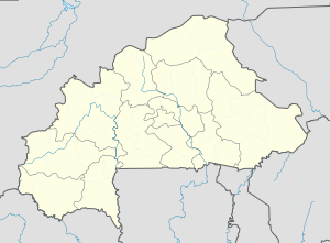
|pushpin_map_caption =Location in Burkina Faso |
|||
|subdivision_type = Country |
|||
|subdivision_name = {{flag|Burkina Faso}} |
|||
|subdivision_type1 = [[Regions of Burkina Faso|Region]] |
|||
|subdivision_name1 = [[Centre-Est Region]] |
|||
|subdivision_type2 = [[Provinces of Burkina Faso|Province]] |
|||
|subdivision_name2 = [[Boulgou Province]] |
|||
|subdivision_type3 = [[Departments of Burkina Faso|Department]] |
|||
|subdivision_name3 = [[Tenkodogo Department]] |
|||
|subdivision_type4 = |
|||
|subdivision_name4 = |
|||
|leader_name = |
|||
|leader_title1 = |
|||
|area_total_km2 = |
|||
|population_as_of =2005 est. |
|||
|population_footnotes = |
|||
|population_note = |
|||
|population_total =749 |
|||
|population_density_km2 = |
|||
|population_density_sq_mi = |
|||
|population_blank1_title =Ethnicities |
|||
|population_blank1 = |
|||
|population_blank2_title =Religions |
|||
|population_blank2 = |
|||
|population_density_blank1_km2 = |
|||
|population_density_blank1_sq_mi = |
|||
|timezone = |
|||
|utc_offset = |
|||
|timezone_DST = |
|||
|utc_offset_DST = |
|||
|coordinates = {{Coord|12.5009|0.6091|display=title}} |
|||
|elevation_footnotes = |
|||
|elevation_m = |
|||
|elevation_ft = |
|||
|postal_code_type = |
|||
|postal_code = |
|||
|area_code = |
|||
|blank_name = |
|||
|blank_info = |
|||
|blank1_name = |
|||
|blank1_info = |
|||
|website = |
|||
|footnotes = |
|||
}} |
|||
'''Bado''' is a village in the [[Tenkodogo Department]] of [[Boulgou Province]] in south-eastern [[Burkina Faso]]. As of 2005, the village has a population of 749.<ref>[https://web.archive.org/web/20061123141450/http://www.inforoute-communale.gov.bf/list_vill/centre_est.htm Burkinabé government inforoute communale]</ref> |
|||
==References== |
|||
The BADO is an annual event held on the second Saturday of December. |
|||
{{Reflist}} |
|||
{{Boulgou}} |
|||
The event usually runs from 11am in the ML3 area of South Lanarkshire, and lasts around 14-16 hours. |
|||
[[Category:Populated places in the Centre-Est Region]] |
|||
In previous years there have been a few casualties, mainly last year being Michael O'Farrell, who did not make the evening meal. |
|||
[[Category:Boulgou Province]] |
|||
This years BADO, on the 11th December, is thought to be the biggest, wildest and greatest BADO yet. |
|||
{{Boulgou-geo-stub}} |
|||
Latest revision as of 15:18, 28 June 2022
Bado | |
|---|---|
| Coordinates: 12°30′03″N 0°36′33″E / 12.5009°N 0.6091°E | |
| Country | |
| Region | Centre-Est Region |
| Province | Boulgou Province |
| Department | Tenkodogo Department |
| Population (2005 est.) | |
• Total | 749 |
Bado is a village in the Tenkodogo Department of Boulgou Province in south-eastern Burkina Faso. As of 2005, the village has a population of 749.[1]
References
[edit]


