Module:Location map/data/Indonesia Lombok/doc: Difference between revisions
Appearance
Content deleted Content added
Dr. Blofeld (talk | contribs) ←Created page with '{{#switch:{{{1}}}| | name=Lombok | top=-7.75 | bottom=-9.1666666666 | left=114.25 | right=116 | image=Lombok Topography.png }}<noinclude>{{Location map/Info}} [[C...' |
m Moving Category:Indonesia location map templates to Category:Indonesia location map modules per Wikipedia:Categories for discussion/Speedy |
||
| (10 intermediate revisions by 8 users not shown) | |||
| Line 1: | Line 1: | ||
<!-- Place categories where indicated at the bottom of this page; interwikis at Wikidata --> |
|||
{{#switch:{{{1}}}| |
|||
{{Module:Location map/data/doc |
|||
| name=Lombok |
|||
| see also = |
|||
| top=-7.75 |
|||
* [[Module:Location map/data/Indonesia]] |
|||
| bottom=-9.1666666666 |
|||
}}<includeonly>{{#ifeq:{{SUBPAGENAME}}|sandbox|| |
|||
| left=114.25 |
|||
<!-- Categories below this line; interwikis at Wikidata --> |
|||
| right=116 |
|||
| ⚫ | |||
| image=Lombok Topography.png |
|||
}}<noinclude>{{Location map/Info}} |
|||
}}</includeonly> |
|||
| ⚫ | |||
</noinclude> |
|||
Latest revision as of 06:01, 4 July 2022
| name | Lombok | |||
|---|---|---|---|---|
| border coordinates | ||||
| -7.833 | ||||
| 115.666 | ←↕→ | 117 | ||
| -9.167 | ||||
| map center | 8°30′00″S 116°19′59″E / 8.5°S 116.333°E | |||
| image | Lombok Locator Topography.png
| |||

| ||||
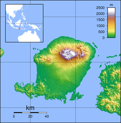
Module:Location map/data/Indonesia Lombok is a location map definition used to overlay markers and labels on an equirectangular projection map of Lombok. The markers are placed by latitude and longitude coordinates on the default map or a similar map image.
Usage
These definitions are used by the following templates when invoked with parameter "Indonesia Lombok":
{{Location map|Indonesia Lombok |...}}{{Location map many|Indonesia Lombok |...}}{{Location map+|Indonesia Lombok |...}}{{Location map~|Indonesia Lombok |...}}
Map definition
name = Lombok- Name used in the default map caption
image = Lombok Locator Topography.png- The default map image, without "Image:" or "File:"
top = -7.833- Latitude at top edge of map, in decimal degrees
bottom = -9.167- Latitude at bottom edge of map, in decimal degrees
left = 115.666- Longitude at left edge of map, in decimal degrees
right = 117- Longitude at right edge of map, in decimal degrees
Precision
Longitude: from West to East this map definition covers 1.334 degrees.
- At an image width of 200 pixels, that is 0.0067 degrees per pixel.
- At an image width of 1000 pixels, that is 0.0013 degrees per pixel.
Latitude: from North to South this map definition covers 1.334 degrees.
- At an image height of 200 pixels, that is 0.0067 degrees per pixel.
- At an image height of 1000 pixels, that is 0.0013 degrees per pixel.
See also
Location map templates
- Template:Location map, to display one mark and label using latitude and longitude
- Template:Location map many, to display up to nine marks and labels
- Template:Location map+, to display an unlimited number of marks and labels
