Ath Aissa Mimoun: Difference between revisions
Appearance
Content deleted Content added
←Created page with 'Ath Aissa Mimoune is a borough in the District of Ouaguenoun. Its headquarters is in Labdhahi. Main villages include: Ighil Bouchene, Akaoudj, Tala Gahia,...' |
Firefly115 (talk | contribs) added Category:Tizi Ouzou Province using HotCat |
||
| (20 intermediate revisions by 15 users not shown) | |||
| Line 1: | Line 1: | ||
{{Infobox settlement |
|||
Ath Aissa Mimoune is a borough in the District of [[Ouaguenoun]]. Its headquarters is in Labdhahi. Main villages include: [[Ighil Bouchene]], Akaoudj, Tala Gahia, Lazib Agni Namar. |
|||
|official_name = Aït Aissa Mimoun |
|||
|other_name = ''Ath Aissa Mimoun'' / آيت عيسى ميمون |
|||
|native_name = |
|||
|nickname = |
|||
|settlement_type =Commune and town |
|||
|motto = |
|||
|image_skyline = Montaignes Akaoudj.jpg |
|||
|imagesize = |
|||
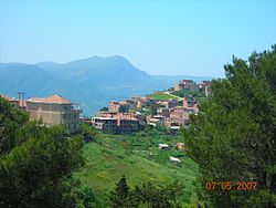
|image_caption = View of [[Akaoudj]] |
|||
|image_flag = |
|||
|flag_size = |
|||
|image_seal = |
|||
|seal_size = |
|||
|image_map = DZ 15 Aït Aïssa Mimoun.svg |
|||
|mapsize = 180px |
|||
|map_caption = Location in Tizi Ouzou Province |
|||
|pushpin_map = Algeria |
|||
|pushpin_label_position =bottom |
|||
|pushpin_mapsize= |
|||
|pushpin_map_caption = |
|||
|subdivision_type = Country |
|||
|subdivision_name ={{flag|Algeria}} |
|||
|subdivision_type1 = [[Provinces of Algeria|Province]] |
|||
|subdivision_name1 =[[Tizi Ouzou Province|Tizi Ouzou]] |
|||
|subdivision_type2 = [[Districts of Algeria|District]] |
|||
|subdivision_name2 = [[Ouaguenoun]] |
|||
|subdivision_type3 = |
|||
|subdivision_name3 = |
|||
|government_footnotes = |
|||
|government_type = |
|||
|leader_title = |
|||
|leader_name = |
|||
|established_title = |
|||
|established_date = |
|||
|area_magnitude = |
|||
|unit_pref = Imperial |
|||
|area_footnotes = |
|||
|area_total_km2 =36.3 |
|||
|area_land_km2 = |
|||
|population_as_of = 2008<ref>[http://www.tiziouzou-dz.com/population-evolu-intercensit.htm Evolution intercensitaire de la population sur le site de la wilaya de Tizi Ouzou] {{webarchive|url=https://web.archive.org/web/20120425143108/http://www.tiziouzou-dz.com/population-evolu-intercensit.htm |date=2012-04-25 }}. Consulté le 25/02/2011</ref> |
|||
|population_footnotes = |
|||
|population_note = |
|||
|population_total = 20268 |
|||
|population_density_km2 = |
|||
|timezone = [[Central European Time|CET]] |
|||
|utc_offset = +1 |
|||
|coordinates = {{coord|36.7602|4.1365|display=inline}} |
|||
|elevation_footnotes = |
|||
|elevation_m = 801 |
|||
|elevation_ft = |
|||
|postal_code_type = |
|||
|postal_code =15640 |
|||
|area_code = |
|||
|blank_name = |
|||
|blank_info = |
|||
|website = |
|||
|footnotes = |
|||
}} |
|||
'''Aït Aissa Mimoune''', [[Kabyle language|Kabyle]] name '''Ath Aissa Mimoune''', known formerly ''Djebel Aïssa Mimoun'',<ref name="JO-91-10">[http://www.joradp.dz/JO8499/1991/010/FP311.pdf Décret exécutif 91-62 du 2 mars 1991 portant changement du nom et transfert du siège de la commune de Djebel Aïssa Mimoun (wilaya de Tizi Ouzou) - Journal officiel de la République algérienne démocratique et populaire numéro=10.]</ref> is a [[Communes of Algeria|commune]] (borough) in the District of [[Ouaguenoun]], [[Tizi Ouzou Province]], [[Kabylie]] region, Algeria. |
|||
==Commune of Aït Aissa Mimoune== |
|||
Its headquarters are in [[Labdhahi]]. The commune includes 23 villages: |
|||
* Agharmiou |
|||
* Agouni Taga |
|||
* Aït Khelfats |
|||
* Aït Brahem (Ath Brahem) |
|||
* [[Akaoudj]] |
|||
* Akhrib Azza |
|||
* Asma |
|||
* Boussouar |
|||
* Dhalouth |
|||
* El Kelâa |
|||
* [[Ighil Bouchène]] |
|||
* Igounane Ameur (Laziv) |
|||
* Ikhelouiyène |
|||
* Imkechrene |
|||
* Menâam |
|||
* Mendjeh |
|||
* Oumlil |
|||
* Thahanouts |
|||
* [[Thala Gahia]] |
|||
* Thimeli |
|||
* Timizart Boualim |
|||
* Tizi Tekharoubt |
|||
* Thizi Tzougarth |
|||
==See also== |
|||
{{Portal|Algeria}} |
|||
*[[Communes of Algeria]] |
|||
==References== |
|||
{{reflist}} |
|||
==External links== |
|||
* {{commonscat inline|Aït Aïssa Mimoun}} |
|||
{{Tizi Ouzou Province}} |
|||
{{coord|36.7602|N|4.1365|E|source:wikidata-and-enwiki-cat-tree_region:DZ|display=title}} |
|||
[[Category:Populated places in Tizi Ouzou Province]] |
|||
[[Category:Tizi Ouzou Province]] |
|||
{{TiziOuzou-geo-stub}} |
|||
Latest revision as of 17:36, 16 December 2022
Aït Aissa Mimoun
Ath Aissa Mimoun / آيت عيسى ميمون | |
|---|---|
Commune and town | |
 View of Akaoudj | |
 Location in Tizi Ouzou Province | |
| Coordinates: 36°45′37″N 4°08′11″E / 36.7602°N 4.1365°E | |
| Country | |
| Province | Tizi Ouzou |
| District | Ouaguenoun |
| Area | |
• Total | 14.0 sq mi (36.3 km2) |
| Elevation | 2,628 ft (801 m) |
| Population (2008[1]) | |
• Total | 20,268 |
| Time zone | UTC+1 (CET) |
Aït Aissa Mimoune, Kabyle name Ath Aissa Mimoune, known formerly Djebel Aïssa Mimoun,[2] is a commune (borough) in the District of Ouaguenoun, Tizi Ouzou Province, Kabylie region, Algeria.
Commune of Aït Aissa Mimoune
[edit]Its headquarters are in Labdhahi. The commune includes 23 villages:
- Agharmiou
- Agouni Taga
- Aït Khelfats
- Aït Brahem (Ath Brahem)
- Akaoudj
- Akhrib Azza
- Asma
- Boussouar
- Dhalouth
- El Kelâa
- Ighil Bouchène
- Igounane Ameur (Laziv)
- Ikhelouiyène
- Imkechrene
- Menâam
- Mendjeh
- Oumlil
- Thahanouts
- Thala Gahia
- Thimeli
- Timizart Boualim
- Tizi Tekharoubt
- Thizi Tzougarth
See also
[edit]References
[edit]- ^ Evolution intercensitaire de la population sur le site de la wilaya de Tizi Ouzou Archived 2012-04-25 at the Wayback Machine. Consulté le 25/02/2011
- ^ Décret exécutif 91-62 du 2 mars 1991 portant changement du nom et transfert du siège de la commune de Djebel Aïssa Mimoun (wilaya de Tizi Ouzou) - Journal officiel de la République algérienne démocratique et populaire numéro=10.
External links
[edit] Media related to Aït Aïssa Mimoun at Wikimedia Commons


