Fjords in the Faroe Islands: Difference between revisions
→Terminology: Fixed typo Tags: canned edit summary Mobile edit Mobile app edit Android app edit |
Edited picture content |
||
| (14 intermediate revisions by 9 users not shown) | |||
| Line 1: | Line 1: | ||
| ⚫ | |||
{{refimprove|date=December 2020}} |
|||
| ⚫ | |||
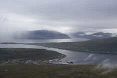
[[File:Faroe Islands, Eysturoy, Syđrugøta (1).jpg|thumb|234px|Gøtuvík (Eysturoy)]] |
|||
| ⚫ | |||
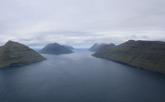
[[File:Faroe Islands, Streymoy, Kaldbaksbotnur.jpg|thumb|234px|Kaldbaksfjørður (Streymoy)]] |
|||
The [[Faroe Islands]] consist of 18 islands and numerous skerries, some of which are deeply inclined by [[Fjord|fjords]]. The [[Faroese language|Faroese]] word for fjord, ''fjørður'' (plural ''firðir''), also indicates channels between islands, both in [[Toponymy|geographical names]] and in everyday speech. This article lists all Faroese ''firðir''. |
|||
[[File:Faroe Islands, Borðoy, Klaksvik and Borðoyarvík.jpg|thumb|234px|Borðoyarvík (Borðoy)]] |
|||
[[File:Faroe Islands, Eysturoy, Funningur (5).jpg|thumb|234px|Funningsfjørður (Eysturoy)]] |
|||
| ⚫ | |||
The [[Faroe Islands]] consist of 18 islands, several of which are deeply incised by [[Fjord|fjords]]. |
|||
== Terminology == |
== Terminology == |
||
The [[Faroese language|Faroese]] word for fjord, ''fjørður'' (plural ''firðir''), can indicate both inlets and [[Firth|firths]] (which corresponds with how the word ''fjord'' is used in English), and channels between islands. This holds true for both the [[suffix]] in [[Toponymy|geographical names]] and for everyday speech. |
|||
| ⚫ | |||
| ⚫ | |||
| ⚫ | * -fjørður (plural: firðir): either a narrow inlet, [[firth]] approaching an inlet, or a [[strait]] between islands.<ref>{{Cite web|title=Sprotin Faroese Dictionary|url=http://www.sprotin.fo}}</ref><ref>{{Cite book|last=Guttesen|first=Rolf|title=The Faeroe Islands Topographic Atlas|publisher=The Royal Danish Geographical Society and Kort & Matrikelstyrelsen|year=1996|location=Copenhagen}}</ref> |
||
* -vík: bay, wide [[inlet]] |
|||
| ⚫ | |||
* -flógvi: [[gulf]] |
|||
* - |
* -vík: V-shaped bay or [[inlet]] |
||
* -pollur(in): small round [[bay]], anchorage |
|||
* -vágur (plural: vágar): small elongated bay |
* -vágur (plural: vágar): small elongated bay |
||
* -botnur: |
* -botnur: head of a fjord, bottom, [[cirque]]. |
||
Water suffixes in other Scandinavian names are often Faroenised, e.g. ''Limfjørður'' for [[Limfjord]] and |
Water suffixes in other Scandinavian names are often Faroenised, e.g. ''Limfjørður'' for [[Limfjord]] in Denmark and ''St. Georgesfjørður'' for [[Saint George's Channel]] between Wales and Ireland.<ref name=":0">{{cite book|title=Heimsatlas|date=1994|publisher=Føroya Skúlabókagrunnur|location=Tórshavn|language=fo|trans-title=World Atlas}}</ref> In a few cases Faroese [[Exonym|exonyms]] exist, such as Oyrarsund ([[Øresund]]) and Ermarsund ([[English Channel]]). |
||
Fjords and straits also act as cultural boundaries, for example linguistically (as [[Isogloss|isoglosses]]) and as identity markers. For example, the [[Skopunarfjørður]] serves as the cultural delineation of ''norðanfjørðs'' ("north of the strait", Northern Faroe) and ''sunnanfjørðs'' ("south of the strait", Southern Faroe).<ref>{{Cite web|last=Sprotin.fo|title=sunnanfjørðs|url=https://sprotin.fo/dictionaries?_SearchInflections=0&_SearchDescriptions=0&_DictionaryId=2&_DictionaryPage=1&_SearchFor=sunnanfj%C3%B8r%C3%B0s&_l=fo|access-date=2021-06-22|website=Sprotin.fo|language=fo}}</ref> |
|||
| ⚫ | |||
[[File:Skálafjørður.jpg|alt=Skálafjørður|thumb|Skálafjørður (centre) and Tangafjørður (far left)]] |
|||
| ⚫ | This list includes all 'traditional' dead-ending fjords with the [[suffix]] -''fjørður.'' In some cases, the name more strictly refers to the |
||
== Fjords and firths in the Faroe Islands == |
|||
<ref>{{Cite web|last=|first=|date=|title=Kortal GIS|url=http://www.kortal.fo/|url-status=live|archive-url=|archive-date=|access-date=|website=}}</ref> |
|||
| ⚫ | This list includes all 'traditional' dead-ending fjords with the [[suffix]] -''fjørður.'' In some cases, the name more strictly refers to the seaward approaches to the inlet, rather than the sheltered reaches of the inlet.<ref name=":0" /> In this list, these are indicated by the [[cognate]] word ''[[firth]]''.<ref>{{Cite web|title=Kortal GIS|url=http://www.kortal.fo/}}</ref> |
||
* Árnafjørður ([[Borðoy]]) |
* Árnafjørður ([[Borðoy]]) |
||
| Line 33: | Line 37: | ||
* [[Trongisvágsfjørður]] (firth branching into [[Trongisvágur]] and [[Øravík]], [[Suðuroy]]) |
* [[Trongisvágsfjørður]] (firth branching into [[Trongisvágur]] and [[Øravík]], [[Suðuroy]]) |
||
* Hovsfjørður ([[Suðuroy]]) |
* Hovsfjørður ([[Suðuroy]]) |
||
* Vágsfjørður (firth branching into [[Vágur]] and Lopransfjørður) |
* Vágsfjørður (firth branching into [[Vágur]] and Lopransfjørður, [[Suðuroy]]) |
||
* Lopransfjørður ([[Suðuroy]]) |
* Lopransfjørður ([[Suðuroy]]) |
||
* Víkarfjørður ([[Suðuroy]]) |
* Víkarfjørður ([[Suðuroy]]) |
||
| Line 41: | Line 45: | ||
== Straits in the Faroe Islands == |
== Straits in the Faroe Islands == |
||
| ⚫ | |||
Ending with ''-fjørður'': |
Ending with ''-fjørður'': |
||
| Line 68: | Line 71: | ||
* Vestmannasund ([[Streymoy]] and [[Vágar]]) |
* Vestmannasund ([[Streymoy]] and [[Vágar]]) |
||
* Kolturssund ([[Koltur]] and [[Hestur]]) |
* Kolturssund ([[Koltur]] and [[Hestur]]) |
||
Of these straits, six are crossed by [[List of tunnels of the Faroe Islands|fixed road links]] and ten by [[Strandfaraskip Landsins|ferries]]. |
|||
== Major bays and inlets with a different suffix == |
== Major bays and inlets with a different suffix == |
||
| Line 83: | Line 88: | ||
<references /> |
<references /> |
||
{{coord missing|Denmark}} |
|||
| ⚫ | |||
| ⚫ | |||
| ⚫ | |||
| ⚫ | |||
Latest revision as of 09:12, 4 January 2023


The Faroe Islands consist of 18 islands, several of which are deeply incised by fjords.
Terminology
[edit]The Faroese word for fjord, fjørður (plural firðir), can indicate both inlets and firths (which corresponds with how the word fjord is used in English), and channels between islands. This holds true for both the suffix in geographical names and for everyday speech.
- -fjørður (plural: firðir): either a narrow inlet, firth approaching an inlet, or a strait between islands.[1][2]
- -sund (plural: sundini): sound, narrow channel.
- -vík: V-shaped bay or inlet
- -pollur(in): small round bay, anchorage
- -vágur (plural: vágar): small elongated bay
- -botnur: head of a fjord, bottom, cirque.
Water suffixes in other Scandinavian names are often Faroenised, e.g. Limfjørður for Limfjord in Denmark and St. Georgesfjørður for Saint George's Channel between Wales and Ireland.[3] In a few cases Faroese exonyms exist, such as Oyrarsund (Øresund) and Ermarsund (English Channel).
Fjords and straits also act as cultural boundaries, for example linguistically (as isoglosses) and as identity markers. For example, the Skopunarfjørður serves as the cultural delineation of norðanfjørðs ("north of the strait", Northern Faroe) and sunnanfjørðs ("south of the strait", Southern Faroe).[4]
Fjords and firths in the Faroe Islands
[edit]This list includes all 'traditional' dead-ending fjords with the suffix -fjørður. In some cases, the name more strictly refers to the seaward approaches to the inlet, rather than the sheltered reaches of the inlet.[3] In this list, these are indicated by the cognate word firth.[5]
- Árnafjørður (Borðoy)
- Funningsfjørður (Eysturoy)
- Oyndarfjørður (Eysturoy)
- Fuglafjørður (Eysturoy)
- Skálafjørður (Eysturoy)
- Kollafjørður (Streymoy)
- Kaldbaksfjørður (Streymoy)
- Sørvágsfjørður (firth towards Sørvágur, Vágar)
- Hvalbiarfjørður (Suðuroy)
- Trongisvágsfjørður (firth branching into Trongisvágur and Øravík, Suðuroy)
- Hovsfjørður (Suðuroy)
- Vágsfjørður (firth branching into Vágur and Lopransfjørður, Suðuroy)
- Lopransfjørður (Suðuroy)
- Víkarfjørður (Suðuroy)
- Mýarfjørður (firth in Suðuroy)
In addition, the village of Søldarfjørður is situated on the Skálafjørður coast, but no fjord-of-the-same name exists.
Straits in the Faroe Islands
[edit]Ending with -fjørður:
- Tangafjørður (Eysturoy and Streymoy)
- Nólsoyarfjørður (Streymoy and Nólsoy)
- Mykinesfjørður (Vágar and Mykines)
- Vágafjørður (gulf between Vágar, Streymoy and Koltur)
- Hestfjørður (Koltur, Hestur and Streymoy)
- Skopunarfjørður (Hestur, Streymoy and Sandoy)
- Skúvoyarfjørður (Sandoy and Skúvoy)
- Dímunarfjørður (Skúvoy and Stóra Dímun)
- Suðuroyarfjørður (Stóra Dímun and Suðuroy, on either side of Lítla Dímun)
Ending with a different suffix:
- Hvannasund (Viðoy and Borðoy)
- Haraldssund (Borðoy and Kunoy)
- Djúpini (Kalsoy and Eysturoy)
- Sundini (Eysturoy and Streymoy)
- Vestmannasund (Streymoy and Vágar)
- Kolturssund (Koltur and Hestur)
Of these straits, six are crossed by fixed road links and ten by ferries.
Major bays and inlets with a different suffix
[edit]- Viðoy: Viðvík
- Svínoy: Svínoyarvík
- Borðoy: Árnafjarðarvík, Borðoyarvík, Pollur, Vágur (Klaksvík)
- Eysturoy: Pollurin (Fuglafjørður), Gøtuvík, Lambavík, Rítuvík, Kongshavn and Eiðisflógvi.
- Streymoy: Tjørnuvík, Pollurin (Saksun), Hvalvík, Vestmannahavn, á Dølunum and Tórshavn.
- Vágar: Miðvágur, Sandavágur, Sørvágur and Víkin.
- Sandoy: Sandsvágur, Grótvík and Húsavík.
- Suðuroy: Sandvík.
References
[edit]- ^ "Sprotin Faroese Dictionary".
- ^ Guttesen, Rolf (1996). The Faeroe Islands Topographic Atlas. Copenhagen: The Royal Danish Geographical Society and Kort & Matrikelstyrelsen.
- ^ a b Heimsatlas [World Atlas] (in Faroese). Tórshavn: Føroya Skúlabókagrunnur. 1994.
- ^ Sprotin.fo. "sunnanfjørðs". Sprotin.fo (in Faroese). Retrieved 2021-06-22.
- ^ "Kortal GIS".
