Kévé: Difference between revisions
Appearance
Content deleted Content added
Calliopejen1 (talk | contribs) No edit summary |
m Dating maintenance tags: {{Cn}} |
||
| (32 intermediate revisions by 24 users not shown) | |||
| Line 1: | Line 1: | ||
{{Update|date=May 2020}} |
|||
{{Infobox |
{{Infobox settlement |
||
<!--See Template:Infobox Settlement for additional fields that may be available--> |
<!--See Template:Infobox Settlement for additional fields that may be available--> |
||
<!--See the Table at Infobox Settlement for all fields and descriptions of usage--> |
<!--See the Table at Infobox Settlement for all fields and descriptions of usage--> |
||
<!-- Basic info ----------------> |
<!-- Basic info ----------------> |
||
|name = |
|name = Kévé |
||
|other_name = |
|other_name = Keye |
||
|nickname = |
|nickname = |
||
|settlement_type = |
|settlement_type = Town |
||
<!-- images and maps -----------> |
<!-- images and maps -----------> |
||
|image_skyline = |
|image_skyline = |
||
| Line 30: | Line 31: | ||
|dot_map_caption = |
|dot_map_caption = |
||
|dot_x = |dot_y = |
|dot_x = |dot_y = |
||
|pushpin_map = <!-- the name of a location map as per http://en.wikipedia.org/wiki/Template:Location_map --> |
|pushpin_map = Togo<!-- the name of a location map as per http://en.wikipedia.org/wiki/Template:Location_map --> |
||
|pushpin_label_position = <!-- the position of the pushpin label: left, right, top, bottom, none --> |
|pushpin_label_position = bottom<!-- the position of the pushpin label: left, right, top, bottom, none --> |
||
|pushpin_map_caption = |
|pushpin_map_caption =Location in Togo |
||
|pushpin_mapsize = |
|pushpin_mapsize = |
||
<!-- Location ------------------> |
<!-- Location ------------------> |
||
| Line 56: | Line 57: | ||
|elevation_ft = |
|elevation_ft = |
||
<!-- Population -----------------------> |
<!-- Population -----------------------> |
||
|population_footnotes =<ref name=telephony>{{cite web|url=http://www.itu.int/ITU-D/pdf/fg7/tog001.doc |title=TELEPHONIE RURALE AU TOGO |publisher=Itu.int |accessdate=2015-06-20}}</ref> |
|||
| ⚫ | |||
| |
|population_est =12,000 |
||
| ⚫ | |||
|population_note =<ref name=telephony>http://yb1zdx.arc.itb.ac.id/data/OWP/library-ref-eng/ref-eng-2/physical/rural-telephony/tog001e.doc</ref> |
|||
|population_total = |
|||
|population_est = |
|||
|pop_est_as_of = |
|||
|population_density_km2 = <!--For automatic calculation, any density field may contain: auto --> |
|population_density_km2 = <!--For automatic calculation, any density field may contain: auto --> |
||
|population_density_sq_mi = |
|population_density_sq_mi = |
||
| Line 69: | Line 67: | ||
|timezone1_DST = |
|timezone1_DST = |
||
|utc_offset1_DST = |
|utc_offset1_DST = |
||
|coordinates = {{coord|6.42781|0.924482|region:TG|display=inline,title}} |
|||
|latd= 6.42781 |
|||
|longd= 0.924482 |
|||
<!-- Area/postal codes & others --------> |
<!-- Area/postal codes & others --------> |
||
|postal_code_type = <!-- enter ZIP code, Postcode, Post code, Postal code... --> |
|postal_code_type = <!-- enter ZIP code, Postcode, Post code, Postal code... --> |
||
|postal_code = |
|postal_code = |
||
|area_code = 337<ref>[http://www.togotel.net.tg/html/nouvelles_numerotation.php?PHPSESSID=\\\] {{webarchive|url=https://web.archive.org/web/20111004063333/http://www.togotel.net.tg/html/nouvelles_numerotation.php?PHPSESSID= |date=October 4, 2011 }}</ref> |
|||
|area_code = |
|||
|footnotes = |
|footnotes = |
||
}} |
}} |
||
''' |
'''Kévé''' (also '''Keye''') is a town and canton with 12,000 residents<ref name=telephony/> in southwest [[Togo]]. |
||
Between 1928 and 1930, the chief of Keve was arrested by [[French language|French]] officials for resisting the French regime.<ref>{{cite book|url=https://books.google.com/books?id=751IQES5RgoC&pg=PA58 |title=Locality, Mobility, and "nation": Periurban Colonialism in Togo's Eweland ... - Benjamin Nicholas Lawrance |isbn=9781580462648 |accessdate=2015-06-20|last1=Lawrance |first1=Benjamin Nicholas |year=2007 }}</ref> As of 1933, Aleke was chief of the town.<ref>{{cite book|url=https://books.google.com/books?id=751IQES5RgoC&pg=PA60 |title=Locality, Mobility, and "nation": Periurban Colonialism in Togo's Eweland ... - Benjamin Nicholas Lawrance |isbn=9781580462648 |accessdate=2015-06-20|last1=Lawrance |first1=Benjamin Nicholas |year=2007 }}</ref> The town Keve is located by 50 km from [[Lomé|Lome]].{{cn|date=January 2023}} The cultural celebration of this region is Avezan or Aveza.{{cn|date=January 2023}} They plant oil palms in their region cause they produce red oil and palm wine.{{cn|date=January 2023}} |
|||
==References== |
==References== |
||
{{ |
{{Reflist}} |
||
{{DEFAULTSORT:Keve}} |
|||
[[Category:Populated places in Maritime Region]] |
|||
| ⚫ | |||
| ⚫ | |||
{{togo-geo-stub}} |
{{togo-geo-stub}} |
||
Latest revision as of 17:46, 15 January 2023
This article needs to be updated. (May 2020) |
Kévé
Keye | |
|---|---|
Town | |
| Coordinates: 6°25′40″N 0°55′28″E / 6.42781°N 0.924482°E | |
| Population | |
• Estimate (2009) | 12,000 |
| Area code | 337[2] |
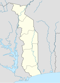
Kévé (also Keye) is a town and canton with 12,000 residents[1] in southwest Togo.
Between 1928 and 1930, the chief of Keve was arrested by French officials for resisting the French regime.[3] As of 1933, Aleke was chief of the town.[4] The town Keve is located by 50 km from Lome.[citation needed] The cultural celebration of this region is Avezan or Aveza.[citation needed] They plant oil palms in their region cause they produce red oil and palm wine.[citation needed]
References
[edit]- ^ a b "TELEPHONIE RURALE AU TOGO". Itu.int. Retrieved 2015-06-20.
- ^ [1] Archived October 4, 2011, at the Wayback Machine
- ^ Lawrance, Benjamin Nicholas (2007). Locality, Mobility, and "nation": Periurban Colonialism in Togo's Eweland ... - Benjamin Nicholas Lawrance. ISBN 9781580462648. Retrieved 2015-06-20.
- ^ Lawrance, Benjamin Nicholas (2007). Locality, Mobility, and "nation": Periurban Colonialism in Togo's Eweland ... - Benjamin Nicholas Lawrance. ISBN 9781580462648. Retrieved 2015-06-20.

