San Ramón, Uruguay: Difference between revisions
Catfurball (talk | contribs) m Added the word municipality and a flag. |
No edit summary Tags: Mobile edit Mobile web edit |
||
| (17 intermediate revisions by 10 users not shown) | |||
| Line 1: | Line 1: | ||
{{Infobox settlement |
{{Infobox settlement |
||
|official_name = San Ramón |
|official_name = San Ramón |
||
|other_name = |
|other_name = |
||
|settlement_type = City & Municipality |
|settlement_type = City & Municipality |
||
|image_skyline = Río santa lucía.jpg |
|image_skyline = Río santa lucía.jpg |
||
|imagesize = |
|imagesize = |
||
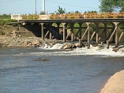
|image_caption = Santa Lucía River at San Ramón |
|image_caption = Santa Lucía River at San Ramón |
||
|pushpin_map = Uruguay |
|pushpin_map = Uruguay |
||
| Line 14: | Line 14: | ||
|established_title = Founded |
|established_title = Founded |
||
|established_date = 1867 |
|established_date = 1867 |
||
|founder = |
|founder = |
||
|population_as_of = 2011 |
|population_as_of = 2011 Census |
||
|population_total = 7133 |
|population_total = 7133 |
||
|population_density_km2 = |
|population_density_km2 = |
||
|area_total_km2 = |
|area_total_km2 = |
||
|timezone = [[UTC]] -3 |
|timezone = [[UTC]] -3 |
||
|coordinates = {{coord|34|18|0|S|55|57|27|W|region:UY-CA|display=inline}} |
|coordinates = {{coord|34|18|0|S|55|57|27|W|region:UY-CA|display=inline}} |
||
| Line 26: | Line 26: | ||
|area_code_type = [[Telephone numbers in Uruguay|Dial plan]] |
|area_code_type = [[Telephone numbers in Uruguay|Dial plan]] |
||
|area_code = +598 4312 (+4 digits) |
|area_code = +598 4312 (+4 digits) |
||
|website = |
|website = |
||
}} |
}} |
||
'''San Ramón''' is a small city in the north of [[Canelones Department]], in southern [[Uruguay]]. |
'''San Ramón''' is a small city in the north of [[Canelones Department]], in southern [[Uruguay]]. |
||
'''San Ramón''' is also the name of the municipality to which the city belongs. |
'''San Ramón''' is also the name of the municipality to which the city belongs. |
||
| ⚫ | |||
| ⚫ | The city is located on the intersection of [[Route 6 (Uruguay)|Route 6]] with Route 12 and Route 63, about {{convert|79|km}} north of [[Kilometre Zero#Uruguay|the centre of]] [[Montevideo]] and {{convert|7.5|km}} south of the village [[Chamizo]] of [[Florida Department]]. The town [[Tala, Uruguay|Tala]] lies {{convert|16|km}} to the east-southeast. The railroad track Montevideo - [[Melo, Uruguay|Melo]] / [[Río Branco, Uruguay|Río Branco]] (to Brazil) passes through the city. |
||
==Geography== |
==Geography== |
||
It is situated on the south bank of [[Santa Lucía River]], which is the border with [[Florida Department]] and south of the hill Cuchilla del Chamizo. The stream Arroyo Pilatos flows {{convert|3|km}} south of the city. |
It is situated on the south bank of [[Santa Lucía River]], which is the border with [[Florida Department]] and south of the hill Cuchilla del Chamizo. The stream Arroyo Pilatos flows {{convert|3|km}} south of the city. |
||
| ⚫ | |||
| ⚫ | The city is located on the intersection of [[Route 6 (Uruguay)|Route 6]] with Route 12 and Route 63, about {{convert|79|km}} north of [[Kilometre Zero#Uruguay|the centre of]] [[Montevideo]] and {{convert|7.5|km}} south of the village [[Chamizo]] of [[Florida Department]]. The town [[Tala, Uruguay|Tala]] lies {{convert|16|km}} to the east-southeast. The railroad track Montevideo - [[Melo, Uruguay|Melo]] / [[Río Branco, Uruguay|Río Branco]] (to Brazil) passes through the city. |
||
==History== |
==History== |
||
San Ramón was founded as a " |
San Ramón was founded as a "(village) in 1867, and on 11 July 1910, its status was elevated to "Villa" town (pueblo) by the Act of Ley Nº 3.643.<ref name=stats/> On 26 June 1953, its status was further elevated to "Ciudad" (city) by the Act of Ley Nº 11.952.<ref>{{cite web |url=http://www0.parlamento.gub.uy/leyes/AccesoTextoLey.asp?Ley=11952 |title=LEY N° 11.952 |publisher=República Oriental del Uruguay, Poder Legislativo |year=1953 |access-date=9 September 2012 |url-status=dead|archive-url=https://web.archive.org/web/20150610203119/http://www0.parlamento.gub.uy/leyes/AccesoTextoLey.asp?Ley=11952 |archive-date=10 June 2015 }}</ref> |
||
== Population == |
== Population == |
||
In 2011 San Ramón had a population of 7,133.<ref>{{cite web |url=http://www.ine.gub.uy/censos2011/resultadosfinales/cuadros/NIVEL%20DEPARTAMENTAL/Canelones/P_3_CAN.xls |title=Censos 2011 Cuadros Canelones |year=2012 |publisher=INE | |
In 2011 San Ramón had a population of 7,133.<ref>{{cite web |url=http://www.ine.gub.uy/censos2011/resultadosfinales/cuadros/NIVEL%20DEPARTAMENTAL/Canelones/P_3_CAN.xls |title=Censos 2011 Cuadros Canelones |year=2012 |publisher=INE |access-date=25 August 2012}}</ref> In 2010, the ''Intendencia de Canelones'' had estimated a population of 8,123 for the municipality during the elections.<ref>{{cite web|url=http://www.observa.com.uy/Municipales2010/nota.aspx?id=96430&ex=33&ar=1&fi=39|title=ELECCIONES - Canelones|publisher=[[El Observador (Uruguay)|El Observador]]|access-date=2 February 2012|url-status=dead|archive-url=https://web.archive.org/web/20120312024255/http://www.observa.com.uy/Municipales2010/nota.aspx?id=96430&ex=33&ar=1&fi=39|archive-date=12 March 2012}}</ref> |
||
Tambien es el lugar donde nacio el conocido CABEZAURIO Mario Testore |
|||
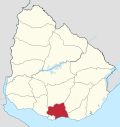
[[File:MunCanSnRamon.svg|thumb|Location map of the Municipality of San Ramón]] |
[[File:MunCanSnRamon.svg|thumb|Location map of the Municipality of San Ramón]] |
||
{| class="wikitable" style="line-height:1.1em;" |
{| class="wikitable" style="line-height:1.1em;" |
||
| Line 54: | Line 52: | ||
|- align="right" |
|- align="right" |
||
| 1975 || 6,594 |
| 1975 || 6,594 |
||
|- align="right" |
|- align="right" |
||
| 1985 || 7,001 |
| 1985 || 7,001 |
||
|- align="right" |
|- align="right" |
||
| Line 63: | Line 61: | ||
| 2011 || 7,133 |
| 2011 || 7,133 |
||
|} |
|} |
||
Source: ''Instituto Nacional de Estadística de Uruguay''<ref name=stats>{{cite web |url=http://www.ine.gub.uy/biblioteca/toponimico/Categorizaci%F3n%20localidades%20urbanas%20orden%20alfab%E9tico.pdf |title=Statistics of urban localities (1908–2004) |publisher=INE |year=2012 |format=PDF | |
Source: ''Instituto Nacional de Estadística de Uruguay''<ref name=stats>{{cite web |url=http://www.ine.gub.uy/biblioteca/toponimico/Categorizaci%F3n%20localidades%20urbanas%20orden%20alfab%E9tico.pdf |title=Statistics of urban localities (1908–2004) |publisher=INE |year=2012 |format=PDF |access-date=9 September 2012}}</ref> |
||
==Places of worship== |
==Places of worship== |
||
* [[San Ramón Nonato, San Ramón|St. Raymond Nonnatus Parish Church]] ([[Roman Catholic]])<ref>[http://www.imcanelones.gub.uy/?q=node/3548 Parroquia de San Ramón] {{ |
* [[San Ramón Nonato, San Ramón|St. Raymond Nonnatus Parish Church]] ([[Roman Catholic]])<ref>[http://www.imcanelones.gub.uy/?q=node/3548 Parroquia de San Ramón] {{in lang|es}}</ref> |
||
== Government == |
== Government == |
||
The city mayor as of July 2010 is Beatríz Lamas.<ref>{{cite web |url=http://www.ci.gub.uy/home/home/index.php?menu=sub1_13&t=secciones&secc=225 |title=Municipios de Uruguay |publisher= |
The city mayor as of July 2010 is Beatríz Lamas.<ref>{{cite web |url=http://www.ci.gub.uy/home/home/index.php?menu=sub1_13&t=secciones&secc=225 |title=Municipios de Uruguay |publisher=Congreso de Intendentes |access-date=9 July 2011 |url-status=dead|archive-url=https://web.archive.org/web/20120308153806/http://www.ci.gub.uy/home/home/index.php?menu=sub1_13&t=secciones&secc=225 |archive-date=8 March 2012 }}</ref> |
||
== References == |
== References == |
||
{{ |
{{Reflist}} |
||
== External links == |
== External links == |
||
{{ |
{{Commons category|San Ramón, Canelones}} |
||
* [http://www.ine.gub.uy/mapas/censos2011/para%20colgar%20en%20web/pdf/03_UYCA/Localidades/A1H_03422%20San%20Ramon.pdf Map of San Ramón] |
* [https://web.archive.org/web/20121010043630/http://www.ine.gub.uy/mapas/censos2011/para%20colgar%20en%20web/pdf/03_UYCA/Localidades/A1H_03422%20San%20Ramon.pdf Map of San Ramón] |
||
{{Canelones Department}} |
{{Canelones Department}} |
||
{{Authority control}} |
|||
{{DEFAULTSORT:San Ramon, Uruguay}} |
{{DEFAULTSORT:San Ramon, Uruguay}} |
||
Latest revision as of 04:50, 2 February 2023
San Ramón | |
|---|---|
City & Municipality | |
 Santa Lucía River at San Ramón | |
| Coordinates: 34°18′0″S 55°57′27″W / 34.30000°S 55.95750°W | |
| Country | |
| Department | |
| Founded | 1867 |
| Elevation | 50 m (160 ft) |
| Population (2011 Census) | |
• Total | 7,133 |
| Time zone | UTC -3 |
| Postal code | 90600 |
| Dial plan | +598 4312 (+4 digits) |
San Ramón is a small city in the north of Canelones Department, in southern Uruguay.
San Ramón is also the name of the municipality to which the city belongs.
Geography
[edit]It is situated on the south bank of Santa Lucía River, which is the border with Florida Department and south of the hill Cuchilla del Chamizo. The stream Arroyo Pilatos flows 3 kilometres (1.9 mi) south of the city.
Location
[edit]The city is located on the intersection of Route 6 with Route 12 and Route 63, about 79 kilometres (49 mi) north of the centre of Montevideo and 7.5 kilometres (4.7 mi) south of the village Chamizo of Florida Department. The town Tala lies 16 kilometres (9.9 mi) to the east-southeast. The railroad track Montevideo - Melo / Río Branco (to Brazil) passes through the city.
History
[edit]San Ramón was founded as a "(village) in 1867, and on 11 July 1910, its status was elevated to "Villa" town (pueblo) by the Act of Ley Nº 3.643.[1] On 26 June 1953, its status was further elevated to "Ciudad" (city) by the Act of Ley Nº 11.952.[2]
Population
[edit]In 2011 San Ramón had a population of 7,133.[3] In 2010, the Intendencia de Canelones had estimated a population of 8,123 for the municipality during the elections.[4]

| Year | Population |
|---|---|
| 1908 | 4,956 |
| 1963 | 5,668 |
| 1975 | 6,594 |
| 1985 | 7,001 |
| 1996 | 6,828 |
| 2004 | 6,992 |
| 2011 | 7,133 |
Source: Instituto Nacional de Estadística de Uruguay[1]
Places of worship
[edit]Government
[edit]The city mayor as of July 2010 is Beatríz Lamas.[6]
References
[edit]- ^ a b "Statistics of urban localities (1908–2004)" (PDF). INE. 2012. Retrieved 9 September 2012.
- ^ "LEY N° 11.952". República Oriental del Uruguay, Poder Legislativo. 1953. Archived from the original on 10 June 2015. Retrieved 9 September 2012.
- ^ "Censos 2011 Cuadros Canelones". INE. 2012. Retrieved 25 August 2012.
- ^ "ELECCIONES - Canelones". El Observador. Archived from the original on 12 March 2012. Retrieved 2 February 2012.
- ^ Parroquia de San Ramón (in Spanish)
- ^ "Municipios de Uruguay". Congreso de Intendentes. Archived from the original on 8 March 2012. Retrieved 9 July 2011.
External links
[edit]


