Villa Delia: Difference between revisions
Appearance
Content deleted Content added
m →Population: table style, replaced: {| class="wikitable" → {| class="wikitable" style="line-height:1.1em;" using AWB |
No edit summary Tags: Mobile edit Mobile web edit |
||
| (10 intermediate revisions by 9 users not shown) | |||
| Line 9: | Line 9: | ||
|pushpin_label_position = bottom |
|pushpin_label_position = bottom |
||
|pushpin_map_caption = Location in Uruguay |
|pushpin_map_caption = Location in Uruguay |
||
|coordinates_display = inline,title |
|||
|coordinates_region = UY-MA |
|||
|subdivision_type = Country |
|subdivision_type = Country |
||
|subdivision_name = {{flag|Uruguay}} |
|subdivision_name = {{flag|Uruguay}} |
||
| Line 21: | Line 19: | ||
|area_total_km2 = |
|area_total_km2 = |
||
|timezone = [[UTC]] -3 |
|timezone = [[UTC]] -3 |
||
|coordinates = {{coord|34|52|58|S|54|59|8|W|region:UY-MA|display=inline,title}} |
|||
|latd=34|latm=52|lats=58|latNS=S |
|||
|longd=54|longm=59|longs=8|longEW=W |
|||
|elevation_m = |
|elevation_m = |
||
|postal_code_type = Postal code |
|postal_code_type = Postal code |
||
| Line 30: | Line 27: | ||
|website = |
|website = |
||
}} |
}} |
||
'''Villa Delia''' is a suburb of [[Maldonado, Uruguay|Maldonado]] |
'''Villa Delia''' is a suburb of [[Maldonado, Uruguay|Maldonado]], Uruguay. |
||
== |
==Geography== |
||
The suburb is located on Route 38 and borders the suburbs [[Cerro Pelado]] and [[La Sonrisa]] to the west, [[Barrio Los Aromos]] to the north, and [[Pinares - Las Delicias]] to the south. |
The suburb is located on Route 38 and borders the suburbs [[Cerro Pelado]] and [[La Sonrisa]] to the west, [[Barrio Los Aromos]] to the north, and [[Pinares - Las Delicias]] to the south. |
||
==Population== |
==Population== |
||
In 2011 Villa Delia had a population of 1,703.<ref>{{cite web |
In 2011 Villa Delia had a population of 1,703.<ref>{{cite web|url=http://www.ine.gub.uy/censos2011/resultadosfinales/cuadros/NIVEL%20DEPARTAMENTAL/Maldonado/P_3_MLD.xls |title=Censos 2011 Cuadros Maldonado |date=2012 |publisher=INE |access-date=25 August 2012 |url-status=dead |archive-url=https://web.archive.org/web/20121010041953/http://www.ine.gub.uy/censos2011/resultadosfinales/cuadros/NIVEL%20DEPARTAMENTAL/Maldonado/P_3_MLD.xls |archive-date=October 10, 2012 }}</ref> |
||
{| class="wikitable" style="line-height:1.1em;" |
{| class="wikitable" style="line-height:1.1em;" |
||
! Year || Population |
! Year || Population |
||
| Line 48: | Line 45: | ||
| 2011 || 1,703 |
| 2011 || 1,703 |
||
|} |
|} |
||
Source: ''Instituto Nacional de Estadística de Uruguay''<ref>{{cite web |url=http://www.ine.gub.uy/biblioteca/toponimico/TOPOletraV.doc |title=1963–1996 Statistics / V |publisher= |
Source: ''Instituto Nacional de Estadística de Uruguay''<ref>{{cite web |url=http://www.ine.gub.uy/biblioteca/toponimico/TOPOletraV.doc |title=1963–1996 Statistics / V |publisher=Instituto Nacional de Estadística de Uruguay |date=2004 |format=DOC |access-date=7 July 2011}}</ref> |
||
==References== |
==References== |
||
| Line 54: | Line 51: | ||
==External links== |
==External links== |
||
* [http://www.ine.gub.uy/mapas/censos2011/para%20colgar%20en%20web/pdf/10_UYMA/Localidades/A0H_10320_821_830_832_925_986%20Maldonado%20y%20otras.pdf INE map of Maldonado, Villa Delia, La Sonrisa, Cerro Pelado, Los Aromos and Pinares-Las Delicias] |
* [https://web.archive.org/web/20121010045318/http://www.ine.gub.uy/mapas/censos2011/para%20colgar%20en%20web/pdf/10_UYMA/Localidades/A0H_10320_821_830_832_925_986%20Maldonado%20y%20otras.pdf INE map of Maldonado, Villa Delia, La Sonrisa, Cerro Pelado, Los Aromos and Pinares-Las Delicias] |
||
{{Maldonado Department}} |
{{Maldonado Department}} |
||
| ⚫ | |||
[[Category:Populated places in the Maldonado Department]] |
[[Category:Populated places in the Maldonado Department]] |
||
| ⚫ | |||
Latest revision as of 19:04, 6 February 2023
Villa Delia | |
|---|---|
Suburb of Maldonado | |
| Coordinates: 34°52′58″S 54°59′8″W / 34.88278°S 54.98556°W | |
| Country | |
| Department | Maldonado Department |
| Population (2011) | |
• Total | 1,703 |
| Time zone | UTC -3 |
| Postal code | 20000 |
| Dial plan | +598 42 (+6 digits) |
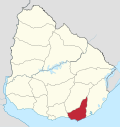
Villa Delia is a suburb of Maldonado, Uruguay.
Geography
[edit]The suburb is located on Route 38 and borders the suburbs Cerro Pelado and La Sonrisa to the west, Barrio Los Aromos to the north, and Pinares - Las Delicias to the south.
Population
[edit]In 2011 Villa Delia had a population of 1,703.[1]
| Year | Population |
|---|---|
| 1985 | 365 |
| 1996 | 583 |
| 2004 | 623 |
| 2011 | 1,703 |
Source: Instituto Nacional de Estadística de Uruguay[2]
References
[edit]- ^ "Censos 2011 Cuadros Maldonado". INE. 2012. Archived from the original on October 10, 2012. Retrieved 25 August 2012.
- ^ "1963–1996 Statistics / V" (DOC). Instituto Nacional de Estadística de Uruguay. 2004. Retrieved 7 July 2011.
External links
[edit]


