Kabiline: Difference between revisions
Appearance
Content deleted Content added
Dr. Blofeld (talk | contribs) No edit summary |
m clean up, replaced: Arrondissment → Arrondissement |
||
| (10 intermediate revisions by 6 users not shown) | |||
| Line 3: | Line 3: | ||
|other_name = |
|other_name = |
||
|native_name = |
|native_name = |
||
|settlement_type = |
|settlement_type =Village |
||
|image_skyline = |
|image_skyline = |
||
|imagesize = |
|imagesize = |
||
| Line 11: | Line 11: | ||
|pushpin_mapsize = 300 |
|pushpin_mapsize = 300 |
||
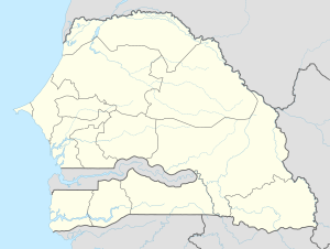
|pushpin_map_caption =Location in Senegal |
|pushpin_map_caption =Location in Senegal |
||
|coordinates_display = inline,title |
|||
|coordinates_region = SN |
|||
|subdivision_type = [[Countries of the world|Country]] |
|subdivision_type = [[Countries of the world|Country]] |
||
|subdivision_type1 = [[Regions of Senegal|Region]] |
|subdivision_type1 = [[Regions of Senegal|Region]] |
||
| Line 19: | Line 17: | ||
|subdivision_type2 = [[Departments of Senegal|Department]] |
|subdivision_type2 = [[Departments of Senegal|Department]] |
||
|subdivision_name2 = [[Bignona Department|Bignona]] |
|subdivision_name2 = [[Bignona Department|Bignona]] |
||
|subdivision_type3 = [[Arrondissements of Senegal| |
|subdivision_type3 = [[Arrondissements of Senegal|Arrondissement]] |
||
|subdivision_name3 = [[ |
|subdivision_name3 = [[Kataba Arrondissement|Kataba]] |
||
|subdivision_type4 |
|subdivision_type4 = [[Communes of Senegal|Commune]] |
||
|subdivision_name4 |
|subdivision_name4 = [[Djinaki]] |
||
|leader_title = |
|leader_title = |
||
|leader_name = |
|leader_name = |
||
| Line 34: | Line 32: | ||
|timezone = [[Greenwich Mean Time|GMT]] |
|timezone = [[Greenwich Mean Time|GMT]] |
||
|utc_offset = +0 |
|utc_offset = +0 |
||
|coordinates = {{coord|12|58|0|N|16|33|24|W|region:SN|display=inline,title}} |
|||
|latd=12|latm=58|lats=24|latNS=N |
|||
|longd=16 |longm=30|longs=25|longEW=W |
|||
|elevation_footnotes = |
|elevation_footnotes = |
||
|elevation_m = |
|elevation_m = |
||
| Line 42: | Line 39: | ||
|footnotes = |
|footnotes = |
||
}} |
}} |
||
'''Kabiline''' is a |
'''Kabiline''' is a large village in the [[Bignona Department]] of the [[Ziguinchor Region]] of southwestern Senegal. In 2002 the village had a population of 3258 people.<ref>{{cite web|url=http://www.pepam.gouv.sn/acces.php?idloc=02112016|title=Localité de Kabiline|publisher=[[Programme d'eau potable et d'assainissement du Millénaire|PEPAM]]|access-date=10 September 2016|archive-url=https://web.archive.org/web/20160303193930/http://www.pepam.gouv.sn/acces.php?idloc=02112016|archive-date=3 March 2016|url-status=dead}}</ref> Surrounded by rivers, it is connected by a road which leads to the [[N5 road (Senegal)|N5 road]], which connects it directly to the district seat of [[Diouloulou]] in the northwest.<ref name="GM">{{Google maps | url =https://www.google.com/maps/place/12%C2%B056'34.0%22N+16%C2%B027'18.0%22W/@12.9564126,-16.4759856,3785m/data=!3m1!1e3!4m5!3m4!1s0x0:0x0!8m2!3d12.942778!4d-16.455?hl=en | accessdate =10 September 2016}}</ref> |
||
In 1982 a group named Entente Kabiline emerged in the village.<ref name="Bosc2005">{{cite book|last=Bosc|first=Pierre-Marie|title=A la croisée des pouvoirs: une organisation paysanne face à la gestion des ressources : Basse Casamance, Sénégal|url=https://books.google.com/books?id=bXA_QSNCY9wC&pg=PA157|year=2005|publisher=IRD Editions|language=fr|isbn=978-2-87614-601-3|page=157}}</ref> In the early 1990s several people were murdered in Kabiline, including Kalifa Didhiou, a former political prisoner, and Famara Mary, a peasant farmer who was executed on 24 June 1990 by soldiers.<ref name="International1991">{{cite book|title=Senegal: an escalation in human rights violations in Casamance region|url=https://books.google.com/books?id=mlFDAQAAIAAJ|year=1991|publisher=Amnesty International U.S.A.|pages=1979–1982}}</ref> |
|||
The village contains Kabiline Primary School.<ref>{{cite book|title=State of the World's Children: Celebrating 20 Years of the Convention on the Rights of the Child|url=https://books.google.com/books?id=TsSsUZ990HUC&pg=PA35|year=2009|publisher=UNICEF|isbn=978-92-806-4442-5|page=35}}</ref> |
|||
==References== |
==References== |
||
{{reflist}} |
{{reflist}} |
||
| ⚫ | |||
[[Category:Arrondissement of Diouloulou]] |
|||
{{Bignona Department}} |
{{Bignona Department}} |
||
| ⚫ | |||
{{Senegal-geo-stub}} |
{{Senegal-geo-stub}} |
||
Latest revision as of 03:42, 5 March 2023
Kabiline | |
|---|---|
Village | |
| Coordinates: 12°58′0″N 16°33′24″W / 12.96667°N 16.55667°W | |
| Country | |
| Region | Ziguinchor |
| Department | Bignona |
| Arrondissement | Kataba |
| Commune | Djinaki |
| Population (2002) | |
• Total | 3,258 |
| Time zone | UTC+0 (GMT) |
Kabiline is a large village in the Bignona Department of the Ziguinchor Region of southwestern Senegal. In 2002 the village had a population of 3258 people.[1] Surrounded by rivers, it is connected by a road which leads to the N5 road, which connects it directly to the district seat of Diouloulou in the northwest.[2]
In 1982 a group named Entente Kabiline emerged in the village.[3] In the early 1990s several people were murdered in Kabiline, including Kalifa Didhiou, a former political prisoner, and Famara Mary, a peasant farmer who was executed on 24 June 1990 by soldiers.[4]
The village contains Kabiline Primary School.[5]
References
[edit]- ^ "Localité de Kabiline". PEPAM. Archived from the original on 3 March 2016. Retrieved 10 September 2016.
- ^ "Kabiline" (Map). Google Maps. Retrieved 10 September 2016.
- ^ Bosc, Pierre-Marie (2005). A la croisée des pouvoirs: une organisation paysanne face à la gestion des ressources : Basse Casamance, Sénégal (in French). IRD Editions. p. 157. ISBN 978-2-87614-601-3.
- ^ Senegal: an escalation in human rights violations in Casamance region. Amnesty International U.S.A. 1991. pp. 1979–1982.
- ^ State of the World's Children: Celebrating 20 Years of the Convention on the Rights of the Child. UNICEF. 2009. p. 35. ISBN 978-92-806-4442-5.

