Ikalamavony (district): Difference between revisions
Appearance
Content deleted Content added
No edit summary |
image |
||
| (7 intermediate revisions by 4 users not shown) | |||
| Line 9: | Line 9: | ||
|motto = |
|motto = |
||
<!-- images and maps -----------> |
<!-- images and maps -----------> |
||
|image_skyline = |
|image_skyline =Anosivola overview.JPG |
||
|imagesize = |
|imagesize = |
||
|image_caption = |
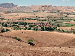
|image_caption = Anosivola, a fokontany of [[Mangidy]] |
||
|image_flag = |
|image_flag = |
||
|flag_size = |
|flag_size = |
||
| Line 114: | Line 114: | ||
|footnotes = |
|footnotes = |
||
}} |
}} |
||
'''[[Ikalamavony]]''' is a small town in [[Haute Matsiatra]] region, in the hills of southern central [[Madagascar]] with a population of 35,114 in 2018. |
|||
The district has a total population of 151,056 inhabitants. With 10,163 km2 it occupies almost half of the surface of [[Haute |
'''[[Ikalamavony]]''' is a district and a small town in [[Haute Matsiatra]] region, in the hills of southern central [[Madagascar]] with a population of 35,114 in 2018. The district has a total population of 151,056 inhabitants. With 10,163 km2 it occupies almost half of the surface of [[Haute Matsiatra]]. The capital of the district is [[Ikalamavony]].<ref>[http://www.regionhautematsiatra.mg/index.php/cartographie-securitaire/c-ikalamavony/ web-site: Haute Matsiatra]</ref> |
||
==Geography== |
|||
It is the capital of the district [[Ikalamavony (district)]].<ref>[http://www.regionhautematsiatra.mg/index.php/cartographie-securitaire/c-ikalamavony/ web-site: Haute Matsiatra]</ref> |
|||
The district is situated at 96 km north-west of [[Fianarantsoa]].<ref>[http://biblio.univ-antananarivo.mg/pdfs/randriambaoJohary_ECO_M1_11.pdf biblio.univ-antananarivo.mg ]</ref> Its main town, Ikalamavony is situated on the [[Route nationale 42 (Madagascar)|National road 42]]. |
|||
==Communes== |
==Communes== |
||
The district is further divided into eight communes: |
|||
* [[Ambatomainty, Ikalamavony|Ambatomainty]] - (45 km from Ikalamavony) |
* [[Ambatomainty, Ikalamavony|Ambatomainty]] - (45 km from Ikalamavony) |
||
* [[Fitampito]] - (50 km from Ikalamavony) |
* [[Fitampito]] - (50 km from Ikalamavony) |
||
* [[Ikalamavony]] |
* '''[[Ikalamavony]]''' |
||
* [[Mangidy]] - (35 km from Ikalamavony) |
* [[Mangidy]] - (35 km from Ikalamavony) |
||
* [[Solila]] - (46 km |
* [[Solila]] - (46 km from Ikalamavony) |
||
* [[Tanamarina Sakay]] |
* [[Tanamarina Sakay]] |
||
* [[Tanamarina]] (also named Tanamarina Bekisopa) |
* [[Tanamarina]] (also named Tanamarina Bekisopa) |
||
| Line 135: | Line 137: | ||
==Rivers== |
==Rivers== |
||
[[Matsiatra]] in the North, and the [[Mananantanana]] river in the South cross the district. The [[Zomandao river]] is another river |
[[Matsiatra]] in the North, and the [[Mananantanana]] river in the South cross the district. The [[Zomandao river]] is another river of importance. |
||
==References== |
==References== |
||
Latest revision as of 06:17, 11 April 2023
Ikalamavony (district) | |
|---|---|
 Anosivola, a fokontany of Mangidy | |
| Coordinates: 21°09′S 46°35′E / 21.150°S 46.583°E | |
| Country | |
| Region | Haute Matsiatra |
| District | Ikalamavony |
| Area | |
• Total | 10,163 km2 (3,924 sq mi) |
| Elevation | 799 m (2,621 ft) |
| Population (2018) | |
• Total | 151,056 |
| Time zone | UTC3 (EAT) |
| Postal code | 314 |
Ikalamavony is a district and a small town in Haute Matsiatra region, in the hills of southern central Madagascar with a population of 35,114 in 2018. The district has a total population of 151,056 inhabitants. With 10,163 km2 it occupies almost half of the surface of Haute Matsiatra. The capital of the district is Ikalamavony.[2]
Geography
[edit]The district is situated at 96 km north-west of Fianarantsoa.[3] Its main town, Ikalamavony is situated on the National road 42.
Communes
[edit]The district is further divided into eight communes:
- Ambatomainty - (45 km from Ikalamavony)
- Fitampito - (50 km from Ikalamavony)
- Ikalamavony
- Mangidy - (35 km from Ikalamavony)
- Solila - (46 km from Ikalamavony)
- Tanamarina Sakay
- Tanamarina (also named Tanamarina Bekisopa)
- Tsitondroina
Roads
[edit]The partly unpaved National road 42 links the town to Isorana and Fianarantsoa (90 km).[4]

Rivers
[edit]Matsiatra in the North, and the Mananantanana river in the South cross the district. The Zomandao river is another river of importance.


