Grassy, Missouri: Difference between revisions
Appearance
Content deleted Content added
Magioladitis (talk | contribs) m →References: clean up using AWB (12084) |
→top: add "use mdy dates" template |
||
| (10 intermediate revisions by 8 users not shown) | |||
| Line 1: | Line 1: | ||
{{Short description|Unincorporated community in the American state of Missouri}} |
|||
{{Use mdy dates|date=July 2023}} |
|||
[[Image:MOMap-doton-Grassy.png|right]] |
[[Image:MOMap-doton-Grassy.png|right]] |
||
'''Grassy''' is an [[Unincorporated area|unincorporated community]] in [[Filmore Township, Bollinger County, Missouri|Filmore Township]] in western [[Bollinger County, Missouri|Bollinger County]], [[Missouri]], |
'''Grassy''' is an [[Unincorporated area|unincorporated community]] in [[Filmore Township, Bollinger County, Missouri|Filmore Township]] in western [[Bollinger County, Missouri|Bollinger County]], [[Missouri]], United States.<ref>{{GNIS|718716}}</ref> |
||
==Geography== |
|||
| ⚫ | Grassy was named for the nearby Grassy Creek on which the community is located. The name |
||
It is eight miles west of [[Marble Hill, Missouri|Marble Hill]] on [[Missouri Route 34|Route 34]].<ref>''Missouri Atlas & Gazetteer,'' DeLorme, 1998, First edition, p. 47, {{ISBN|0-89933-224-2}}</ref> |
|||
Grassy is part of the [[Cape Girardeau, Missouri|Cape Girardeau]]–[[Jackson, Missouri|Jackson]], MO-[[Illinois|IL]] [[Cape Girardeau-Jackson metropolitan area|Metropolitan Statistical Area]].<ref>USA.com http://www.usa.com/cape-girardeau-jackson-mo-il-area.htm</ref> |
Grassy is part of the [[Cape Girardeau, Missouri|Cape Girardeau]]–[[Jackson, Missouri|Jackson]], MO-[[Illinois|IL]] [[Cape Girardeau-Jackson metropolitan area|Metropolitan Statistical Area]].<ref>USA.com http://www.usa.com/cape-girardeau-jackson-mo-il-area.htm</ref> |
||
Located just outside Grassy are three campgrounds along the [[Castor River (Missouri)|Castor River]]: |
Located just outside Grassy are three campgrounds along the [[Castor River (Missouri)|Castor River]]: |
||
Arrowhead Campgrounds,<ref>Arrowheadcampgrounds.com http://www.arrowheadcampgrounds.com/ {{Webarchive|url=https://web.archive.org/web/20130816161704/http://www.arrowheadcampgrounds.com/ |date=2013-08-16 }}</ref> Castor River Park,<ref>Bollinger County, Missouri Chamber of Commerce http://www.bollingercountychamber.com/recreation.asp</ref> and Twin Bridges Park. |
|||
*Castor River Park <ref>Bollinger County, Missouri Chamber of Commerce http://www.bollingercountychamber.com/recreation.asp</ref> |
|||
*Twin Bridges Park |
|||
==History== |
|||
| ⚫ | |||
| ⚫ | Grassy was named for the nearby [[Grassy Creek (Castor River tributary)|Grassy Creek]] on which the community is located. The name of the creek derives from the lush sage grass that grows along the banks and in the bed of the stream.<ref>State Historical Society of Missouri: Bollinger County Place Names, 1928-1945 http://shs.umsystem.edu/manuscripts/ramsay/ramsay_bollinger.html {{Webarchive|url=https://web.archive.org/web/20131029191433/http://shs.umsystem.edu/manuscripts/ramsay/ramsay_bollinger.html |date=2013-10-29 }}</ref> |
||
==References== |
==References== |
||
| Line 17: | Line 19: | ||
{{Bollinger County, Missouri}} |
{{Bollinger County, Missouri}} |
||
| ⚫ | |||
{{authority control}} |
|||
[[Category:Unincorporated communities in Bollinger County, Missouri]] |
[[Category:Unincorporated communities in Bollinger County, Missouri]] |
||
[[Category:Cape |
[[Category:Cape Girardeau–Jackson metropolitan area]] |
||
[[Category:Unincorporated communities in Missouri]] |
[[Category:Unincorporated communities in Missouri]] |
||
Latest revision as of 21:34, 25 July 2023

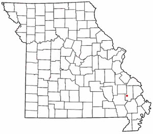
Grassy is an unincorporated community in Filmore Township in western Bollinger County, Missouri, United States.[1]
Geography
[edit]It is eight miles west of Marble Hill on Route 34.[2]
Grassy is part of the Cape Girardeau–Jackson, MO-IL Metropolitan Statistical Area.[3]
Located just outside Grassy are three campgrounds along the Castor River: Arrowhead Campgrounds,[4] Castor River Park,[5] and Twin Bridges Park.
History
[edit]Grassy was named for the nearby Grassy Creek on which the community is located. The name of the creek derives from the lush sage grass that grows along the banks and in the bed of the stream.[6]
References
[edit]- ^ U.S. Geological Survey Geographic Names Information System: Grassy, Missouri
- ^ Missouri Atlas & Gazetteer, DeLorme, 1998, First edition, p. 47, ISBN 0-89933-224-2
- ^ USA.com http://www.usa.com/cape-girardeau-jackson-mo-il-area.htm
- ^ Arrowheadcampgrounds.com http://www.arrowheadcampgrounds.com/ Archived 2013-08-16 at the Wayback Machine
- ^ Bollinger County, Missouri Chamber of Commerce http://www.bollingercountychamber.com/recreation.asp
- ^ State Historical Society of Missouri: Bollinger County Place Names, 1928-1945 http://shs.umsystem.edu/manuscripts/ramsay/ramsay_bollinger.html Archived 2013-10-29 at the Wayback Machine
37°15′39″N 90°07′25″W / 37.26083°N 90.12361°W

