Fairfield Beach (Fairfield): Difference between revisions
m Undid revision 342620298 by Historygal68 (talk) |
→Location: rm more unsourced name drops |
||
| (19 intermediate revisions by 14 users not shown) | |||
| Line 1: | Line 1: | ||
{{Use mdy dates|date=July 2023}} |
|||
'''Fairfield Beach''' is a neighborhood of [[Fairfield, Connecticut]]. |
'''Fairfield Beach''' is a neighborhood of [[Fairfield, Connecticut]]. |
||
==Location== |
==Location== |
||
| ⚫ | Fairfield Beach is located to the south of downtown Fairfield, and the neighborhood extends south from Old Post Road to the [[Long Island Sound]]. The neighborhood originally held a variety of income levels, with small family farms such as the Hauser farm on the corner of Reef Road and Charles Street on one end of the spectrum, and small summer cottages on the beach at the other. While only a few families lived there year |
||
[[File:Fairfield Beach I.jpg|thumb|Entrance to the beach by the pavilion.]] |
|||
Throughout the 1960s and 1970s the neighborhood was also known for its beach bars, including the "Beachside" across from Penfield Beach, and "Flanagan's" on the corner of Reef and Fairfield Beach Road. Before Reef Road was widened, the corner of Reef and Fairfield Beach Road was home to several small stores, including "Danny's" and a fish-and-chips shop owned by Maynard Benson, called "Maynard's Reef." Flanagan's was originally owned by "Chippy" Flanagan but became the "Nautilus" under new ownership, and continued under this name until the 1980s, when the bar was bought, renamed the "Seagrape," and remodeled to attract the student crowd from Fairfield University. |
|||
| ⚫ | Fairfield Beach is located to the south of downtown Fairfield, and the neighborhood extends south from Old Post Road to the [[Long Island Sound]]. The neighborhood originally held a variety of income levels, with small family farms such as the Hauser farm on the corner of Reef Road and Charles Street on one end of the spectrum, and small summer cottages on the beach at the other. While only a few families lived there year-round in the early and mid-twentieth century the neighborhood began growing in popularity for year-round residents throughout the 1970s and 1980s. |
||
Following the overwhelming onslaught of student renters from Fairfield University in the 1970s, and the aggressive expansion of the Seagrape's owners in the 1980s and 1990s, many original residents of the neighborhood fled, driven out by the noise and overcrowding. |
|||
A recent surge in the neighborhood's popularity has led to a building boom, as many of the smaller old homes have been torn down and replaced with the larger new homes. Many of the newer homes have been constructed in a distinctive architectural style known as "Nantucket" or "beach" style. |
|||
<ref>{{cite web |author=Prevost, Lisa |title=LIVING IN/The Fairfield, Conn., Beach Area; A Beach Community in an Awkward Transition|date=2005-07-03 |work=The New York Times |url= |
<ref>{{cite web |author=Prevost, Lisa |title=LIVING IN/The Fairfield, Conn., Beach Area; A Beach Community in an Awkward Transition|date=2005-07-03 |work=The New York Times |url=https://query.nytimes.com/gst/fullpage.html?res=9C05EED71531F930A35754C0A9639C8B63&sec=&spon=&partner=permalink&exprod=permalink}}</ref> |
||
Residents of the neighborhood are represented by several neighborhood organizations, including the Fairfield Beach Residents Association, which represents the entire beach area, and the Fair Acres Association, which represents residents residing within the blocks between Rowland Road and Penfield Road. |
Residents of the neighborhood are represented by several neighborhood organizations, including the Fairfield Beach Residents Association, which represents the entire beach area, and the Fair Acres Association, which represents residents residing within the blocks between Rowland Road and Penfield Road. |
||
| Line 18: | Line 18: | ||
There is a local school, Roger Sherman Elementary. |
There is a local school, Roger Sherman Elementary. |
||
[[File:Fairfield Beach II.jpg|thumb|Seagulls on the beach.]] |
|||
[[File:Fairfield Beach III.jpg|thumb|Pavilion at Fairfield beach.]] |
|||
==Gallery== |
==Gallery== |
||
| Line 38: | Line 41: | ||
{{Coord|41.1218|-73.2573|display=title}} |
{{Coord|41.1218|-73.2573|display=title}} |
||
{{authority control}} |
|||
[[Category:Fairfield, Connecticut]] |
[[Category:Fairfield, Connecticut]] |
||
[[Category:Neighborhoods in Connecticut]] |
[[Category:Neighborhoods in Connecticut]] |
||
[[Category:Beaches of Connecticut]] |
|||
Latest revision as of 16:17, 11 September 2023
Fairfield Beach is a neighborhood of Fairfield, Connecticut.
Location
[edit]
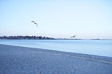
Fairfield Beach is located to the south of downtown Fairfield, and the neighborhood extends south from Old Post Road to the Long Island Sound. The neighborhood originally held a variety of income levels, with small family farms such as the Hauser farm on the corner of Reef Road and Charles Street on one end of the spectrum, and small summer cottages on the beach at the other. While only a few families lived there year-round in the early and mid-twentieth century the neighborhood began growing in popularity for year-round residents throughout the 1970s and 1980s.
A recent surge in the neighborhood's popularity has led to a building boom, as many of the smaller old homes have been torn down and replaced with the larger new homes. Many of the newer homes have been constructed in a distinctive architectural style known as "Nantucket" or "beach" style. [1]
Residents of the neighborhood are represented by several neighborhood organizations, including the Fairfield Beach Residents Association, which represents the entire beach area, and the Fair Acres Association, which represents residents residing within the blocks between Rowland Road and Penfield Road.
Traditionally, many Fairfield University students have lived in the neighborhood, and although their numbers have decreased in recent years as property values and rents have increased, there continues to be a significant student presence, leading to occasional conflict between students and permanent residents.[citation needed]
The area includes Jennings Beach and Penfield Beach; the Veterans Park; and the Fairfield Beach Club and the South Benson Marina.
There is a local school, Roger Sherman Elementary.


Gallery
[edit]-
Postcard from 1932 showing bathers at Fairfield Beach, Connecticut
-
A recent view of Fairfield Beach
-
Penfield Reef Lighthouse is located in the Long Island Sound off the coast of Fairfield Beach
-
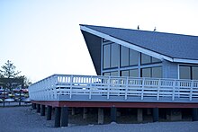
1915 postcard of Fairfield Beach showing what is now Penfield Pavilion
-
A 1921 postcard showing Fairfield Beach
-
Boyle's Beach Casino, a lively dance hall, was located at the corner of Reef Road and Fairfield Beach Road until it burned down in 1915
External links
[edit]References
[edit]- ^ Prevost, Lisa (July 3, 2005). "LIVING IN/The Fairfield, Conn., Beach Area; A Beach Community in an Awkward Transition". The New York Times.


