Pursaklar: Difference between revisions
Appearance
Content deleted Content added
No edit summary |
m →top: infobox |
||
| (16 intermediate revisions by 13 users not shown) | |||
| Line 1: | Line 1: | ||
{{short description|District in West Anatolia, Turkey}} |
|||
{{Infobox settlement <!--more fields are available for this Infobox--See Template:Infobox Settlement--> |
|||
{{Infobox Turkey place |
|||
|settlement_type = District |
|||
| type = metro district |
|||
|coordinates_region = TR |
|||
| name = Pursaklar |
|||
|subdivision_type = [[Countries of the world|Country]] |
|||
| image_skyline = Countryside of Ankara - panoramio.jpg |
|||
|subdivision_name = {{TUR}} |
|||
| image_caption = |
|||
|subdivision_type1 = [[Regions of Turkey|Region]] |
|||
| image_map = Ankara location Pursaklar.svg |
|||
|subdivision_name1 = [[Central Anatolia]] |
|||
| map_caption = Map showing Pursaklar District in Ankara Province |
|||
|subdivision_type2 = [[Provinces of Turkey|Province]] |
|||
| coordinates = {{coord|40|02|19|N|32|53|49|E|region:TR|display=it}} |
|||
|subdivision_name2 = [[Ankara]] |
|||
| province = Ankara |
|||
|timezone= [[Eastern European Time|EET]] |
|||
| leader_party = AKP |
|||
|utc_offset=+2 |
|||
| leader_name = Ertuğrul Çetin |
|||
|image_map= Ankara districts.png |
|||
| leader_name1 = |
|||
|timezone_DST=[[Eastern European Summer Time|EEST]] |
|||
| area_total_km2 = 169 |
|||
|utc_offset_DST=+3 |
|||
| elevation_m = 1049 |
|||
|official_name = Pursaklar |
|||
| population_footnotes = <ref name=tuik/> |
|||
|image_skyline = |
|||
| population_total = 162389 |
|||
|image_caption = |
|||
| population_as_of = 2022 |
|||
|image_blank_emblem = |
|||
| postal_code = |
|||
|blank_emblem_type = |
|||
| area_code = 0312 |
|||
|map cap = Location in [[Turkey]] |
|||
| website = {{url|http://www.pursaklar.bel.tr/}} |
|||
|population_urban = 108211 |
|||
}} |
|||
|population_as_of = 2010 |
|||
'''Pursaklar''' is a municipality and metropolitan [[Districts of Turkey|district]] of [[Ankara Province]], [[Turkey]].<ref>[https://www.e-icisleri.gov.tr/Anasayfa/MulkiIdariBolumleri.aspx Büyükşehir İlçe Belediyesi], Turkey Civil Administration Departments Inventory. Retrieved 8 June 2023.</ref> Its area is 169 km<sup>2</sup>,<ref>{{cite web|url=https://www.harita.gov.tr/uploads/files-folder/il_ilce_alanlari.xlsx|title=İl ve İlçe Yüz ölçümleri|publisher=General Directorate of Mapping|access-date=22 May 2023}}</ref> and its population is 162,389 (2022).<ref name=tuik/> It became a town municipality within the district of [[Keçiören]] in 1986.<ref>[https://www.resmigazete.gov.tr/arsiv/19316.pdf Karar Sayısı: 86/33062], Resmî Gazete, 19 December 1986.</ref> In 2008 it became a district, and the former municipalities of Sarayköy, Sirkeli and Altınova (partly) were added to it.<ref>[https://www.resmigazete.gov.tr/eskiler/2008/03/20080322M1-1.htm Kanun No. 5747], Resmî Gazete, 22 March 2008.</ref><ref>{{Cite web |title=İl İdaresi ve Mülki Bölümler Şube Müdürlüğü İstatistikleri - İl ve İlçe Kuruluş Tarihleri |url=https://www.icisleri.gov.tr/kurumlar/icisleri.gov.tr/IcSite/illeridaresi/İstatistiki%20Bilgiler/İl%20İdaresi%20ve%20Mülki%20Bölümler/il%20ilce%20kurulus%20tarihleri_2019.pdf |access-date=27 June 2023|page=9 |language=tr}}</ref> |
|||
|population_footnotes = |
|||
|population_density_km2 = |
|||
==Composition== |
|||
|area_total_km2 = |
|||
There are 21 [[mahalle|neighbourhoods]] in Pursaklar District:<ref>[https://www.e-icisleri.gov.tr/Anasayfa/MulkiIdariBolumleri.aspx Mahalle], Turkey Civil Administration Departments Inventory. Retrieved 22 May 2023.</ref> |
|||
| pushpin_map = Turkey |
|||
{{div col|colwidth=12em}} |
|||
|latd = 39 |
|||
* [[Abadan, Pursaklar|Abadan]] |
|||
|latm = 58 |
|||
* Altınova |
|||
|latNS = N |
|||
* Ayyıldız |
|||
|longd = 32 |
|||
* Fatih |
|||
|longm = 49 |
|||
* [[Karaköy, Pursaklar|Karaköy]] |
|||
|longEW = E |
|||
* [[Karşıyaka, Pursaklar|Karşıyaka]] |
|||
|elevation_m = 1049|postal_code_type=[[Postal code]] |
|||
* [[Kösrelikkızığı, Pursaklar|Kösrelikkızığı]] |
|||
|postal_code = 06xxx |
|||
* Merkez |
|||
|area_code = 0312 |
|||
* Mimar Sinan |
|||
|blank_info = 06 |
|||
* Peçenek |
|||
|blank_name=[[Turkish car number plates|Licence plate]] |
|||
* Saray Cumhuriyet |
|||
|leader_title = [[Governor]] |
|||
* Saray Fatih |
|||
|leader_name = Dr. Ahmet CENGİZ |
|||
* Saray Gümüşoluk |
|||
|leader_title1 = [[Mayor]] |
|||
* Saray Osmangazi |
|||
|leader_name1 = Selçuk ÇETİN |
|||
* [[Sirkeli Yeşilova]] |
|||
|website = [http://www.pursaklar.gov.tr/ www.pursaklar.gov.tr] |
|||
* Sirkeli Yeşilyurt |
|||
|website = [http://www.pursaklar.bel.tr/ www.pursaklar.bel.tr] |
|||
* Tevfik Ileri |
|||
* Yeni Karaköy |
|||
* Yıldırımbeyazıt |
|||
* Yunus Emre |
|||
* [[Yuva, Pursaklar|Yuva]] |
|||
{{div col end}} |
|||
== Demographics == |
|||
{{Historical populations |
|||
|title = Historical population<ref>Turkish Statistical Institute</ref> |
|||
|align = none |
|||
|cols = 2 |
|||
|shading = off |
|||
|percentages = pagr |
|||
|source = 1997 census,<ref name="TÜİK1997">{{Cite web | url = https://kutuphane.tuik.gov.tr/pdf/0014235.pdf | title = 1997 Population Count | date = 1999 | publisher = [[Turkish Statistical Institute]] | language = Turkish | archive-url = https://web.archive.org/web/20221030113057/https://kutuphane.tuik.gov.tr/pdf/0014235.pdf | archive-date = 30 October 2022 | url-status = live }}</ref> TÜIK (2007)<ref>{{cite web|url=https://biruni.tuik.gov.tr/medas/?kn=95&locale=en |title=Population Of Municipalities, Villages And Quarters|publisher=[[Turkish Statistical Institute|TÜIK]] |access-date=27 June 2023}}</ref> and TÜIK (2008-2022)<ref name=tuik>{{cite web|url=https://biruni.tuik.gov.tr/medas/?kn=95&locale=en |title=Population Of SRE-1, SRE-2, Provinces and Districts|publisher=[[Turkish Statistical Institute|TÜIK]] |access-date=27 June 2023}}</ref> |
|||
|footnote = Population data before 1986 refer to the village of Pursaklar, data between 1986 and 2007 refer to the town municipality of Pursaklar. |
|||
|1965|559 |
|||
|1970|820 |
|||
|1975|1151 |
|||
|1980|1558 |
|||
|1985|2179 |
|||
|1990|3526 |
|||
|1997|13190 |
|||
|2000|27974 |
|||
|2007|64197 |
|||
|2008|91742 |
|||
|2012|119593 |
|||
|2017|142317 |
|||
|2022|162389 |
|||
}} |
}} |
||
==References== |
|||
'''Pursaklar''' is a metropolitan district in the province of [[Ankara Province|Ankara]], the capital of [[Turkey]]. It became a town municipality in 1987, and a [[Districts of Turkey|district]] in 2008. There are 19 neighborhoods under its administration. |
|||
{{reflist}} |
|||
== External links == |
== External links == |
||
| Line 51: | Line 81: | ||
* [http://www.pursaklar.bel.tr/ Municipality of Pursaklar (in Turkish)] |
* [http://www.pursaklar.bel.tr/ Municipality of Pursaklar (in Turkish)] |
||
{{Districts of Turkey|provname=Ankara|sortkey=Pursaklar}} |
|||
{{Pursaklar District}} |
|||
{{Authority control}} |
|||
{{Portal bar|Geography|Turkey}} |
|||
[[ |
[[Category:Pursaklar District| ]] |
||
[[Category:Metropolitan district municipalities in Turkey]] |
|||
[[rw:Pursaklar]] |
|||
[[Category:Populated places in Ankara Province]] |
|||
[[mrj:Пурсаклар]] |
|||
[[Category:Districts of Ankara Province]] |
|||
[[lbe:Пурсакълар]] |
|||
[[pnb:ضلع پرساکلر]] |
|||
[[koi:Пурсаклар]] |
|||
[[sr:Пурсаклар]] |
|||
[[tr:Pursaklar]] |
|||
Latest revision as of 08:33, 26 October 2023
Pursaklar | |
|---|---|
District and municipality | |
 | |
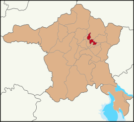
 Map showing Pursaklar District in Ankara Province | |
| Coordinates: 40°02′19″N 32°53′49″E / 40.03861°N 32.89694°E | |
| Country | Turkey |
| Province | Ankara |
| Government | |
| • Mayor | Ertuğrul Çetin (AKP) |
Area | 169 km2 (65 sq mi) |
| Elevation | 1,049 m (3,442 ft) |
| Population (2022)[1] | 162,389 |
| • Density | 960/km2 (2,500/sq mi) |
| Time zone | UTC+3 (TRT) |
| Area code | 0312 |
| Website | www |
Pursaklar is a municipality and metropolitan district of Ankara Province, Turkey.[2] Its area is 169 km2,[3] and its population is 162,389 (2022).[1] It became a town municipality within the district of Keçiören in 1986.[4] In 2008 it became a district, and the former municipalities of Sarayköy, Sirkeli and Altınova (partly) were added to it.[5][6]
Composition
[edit]There are 21 neighbourhoods in Pursaklar District:[7]
- Abadan
- Altınova
- Ayyıldız
- Fatih
- Karaköy
- Karşıyaka
- Kösrelikkızığı
- Merkez
- Mimar Sinan
- Peçenek
- Saray Cumhuriyet
- Saray Fatih
- Saray Gümüşoluk
- Saray Osmangazi
- Sirkeli Yeşilova
- Sirkeli Yeşilyurt
- Tevfik Ileri
- Yeni Karaköy
- Yıldırımbeyazıt
- Yunus Emre
- Yuva
Demographics
[edit]
|
| |||||||||||||||||||||||||||||||||||||||||||||
| Population data before 1986 refer to the village of Pursaklar, data between 1986 and 2007 refer to the town municipality of Pursaklar. Source: 1997 census,[9] TÜIK (2007)[10] and TÜIK (2008-2022)[1] | ||||||||||||||||||||||||||||||||||||||||||||||
References
[edit]- ^ a b c "Population Of SRE-1, SRE-2, Provinces and Districts". TÜIK. Retrieved 27 June 2023.
- ^ Büyükşehir İlçe Belediyesi, Turkey Civil Administration Departments Inventory. Retrieved 8 June 2023.
- ^ "İl ve İlçe Yüz ölçümleri". General Directorate of Mapping. Retrieved 22 May 2023.
- ^ Karar Sayısı: 86/33062, Resmî Gazete, 19 December 1986.
- ^ Kanun No. 5747, Resmî Gazete, 22 March 2008.
- ^ "İl İdaresi ve Mülki Bölümler Şube Müdürlüğü İstatistikleri - İl ve İlçe Kuruluş Tarihleri" (PDF) (in Turkish). p. 9. Retrieved 27 June 2023.
- ^ Mahalle, Turkey Civil Administration Departments Inventory. Retrieved 22 May 2023.
- ^ Turkish Statistical Institute
- ^ "1997 Population Count" (PDF) (in Turkish). Turkish Statistical Institute. 1999. Archived (PDF) from the original on 30 October 2022.
- ^ "Population Of Municipalities, Villages And Quarters". TÜIK. Retrieved 27 June 2023.


