Colwyn Rural District: Difference between revisions
removed Category:History of Powys; added Category:History of Radnorshire using HotCat |
SimLibrarian (talk | contribs) mNo edit summary Tags: Mobile edit Mobile app edit iOS app edit |
||
| (5 intermediate revisions by 5 users not shown) | |||
| Line 1: | Line 1: | ||
{{Short description|Rural district in Radnorshire, Wales}} |
|||
| ⚫ | |||
{{infobox historic subdivision| |
{{infobox historic subdivision| |
||
|Name= Colwyn |
|Name= Colwyn |
||
| Line 29: | Line 29: | ||
The district was formed by the [[Local Government Act 1894]], when the existing Builth [[sanitary district|Rural Sanitary District]] was divided into two: the section in [[Breconshire]] was reconstituted as [[Builth Rural District]] and that in Radnorshire as Colwyn Rural District.<ref>Census of England and Wales 1901, County Report, Brecknockshire</ref> <ref>Census of England and Wales 1901, County Report, Radnorshire</ref> The new district took its name from the ancient [[hundred (division)|hundred]] of Colwyn. The council continued to be based in [[Builth Wells]] in Breconshire. |
The district was formed by the [[Local Government Act 1894]], when the existing Builth [[sanitary district|Rural Sanitary District]] was divided into two: the section in [[Breconshire]] was reconstituted as [[Builth Rural District]] and that in Radnorshire as Colwyn Rural District.<ref>Census of England and Wales 1901, County Report, Brecknockshire</ref> <ref>Census of England and Wales 1901, County Report, Radnorshire</ref> The new district took its name from the ancient [[hundred (division)|hundred]] of Colwyn. The council continued to be based in [[Builth Wells]] in Breconshire. |
||
The rural district comprised ten [[civil parish]]es:<ref>{{cite web |url=http://www.visionofbritain.org.uk/relationships.jsp?u_id=10175483&c_id=10001043 |title=Relationships / unit history of Colwyn |accessdate=2009-02-09 |work=Vision of Britain |publisher=[[University of Portsmouth]] |date= }}</ref> |
The rural district comprised ten [[civil parish]]es:<ref>{{cite web |url=http://www.visionofbritain.org.uk/relationships.jsp?u_id=10175483&c_id=10001043 |title=Relationships / unit history of Colwyn |accessdate=2009-02-09 |work=Vision of Britain |publisher=[[University of Portsmouth]] |archive-url=https://web.archive.org/web/20110604054651/http://www.visionofbritain.org.uk/relationships.jsp?u_id=10175483 |archive-date=2011-06-04 |url-status=dead }}</ref> |
||
{{columns-list| |
{{columns-list|colwidth=30em| |
||
*[[Aberbedw]] |
*[[Aberbedw]] |
||
*Bettws Disserth |
*Bettws Disserth |
||
| Line 47: | Line 47: | ||
{{Reflist}} |
{{Reflist}} |
||
| ⚫ | |||
| ⚫ | |||
| ⚫ | |||
[[Category:History of Radnorshire]] |
[[Category:History of Radnorshire]] |
||
[[Category:Radnorshire]] |
[[Category:Radnorshire]] |
||
Latest revision as of 03:39, 30 October 2023
| Colwyn | |
|---|---|
 | |
| Area | |
| • 1911 | 29,579 acres (119.70 km2) |
| • 1931 | 29,579 acres (119.70 km2) |
| • 1961 | 29,579 acres (119.70 km2) |
| Population | |
| • 1901 | 1,882 |
| • 1931 | 2,043 |
| • 1971 | 1,682 |
| History | |
| • Origin | Sanitary district |
| • Created | 1894 |
| • Abolished | 1974 |
| • Succeeded by | Radnorshire |
| Status | Rural district |
| Government | Colwyn Rural District Council |
| • HQ | Builth Wells |
| Subdivisions | |
| • Type | Civil parishes |
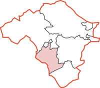
Colwyn was, from 1894 to 1974, a rural district in the administrative county of Radnorshire, Wales.
The district was formed by the Local Government Act 1894, when the existing Builth Rural Sanitary District was divided into two: the section in Breconshire was reconstituted as Builth Rural District and that in Radnorshire as Colwyn Rural District.[1] [2] The new district took its name from the ancient hundred of Colwyn. The council continued to be based in Builth Wells in Breconshire.
The rural district comprised ten civil parishes:[3]
- Aberbedw
- Bettws Disserth
- Cregrina
- Disserth and Trecoed
- Llanbadarn y Garreg
- Llandrindod Rural
- Llanelwedd
- Llanfaredd
- Llansaintfraed in Elvel
- Rhulen
The district was abolished in 1974 under the Local Government Act 1972, which completely reorganised local administration in England and Wales. Its area became part of the District of Radnor in the new county of Powys.
References
[edit]- ^ Census of England and Wales 1901, County Report, Brecknockshire
- ^ Census of England and Wales 1901, County Report, Radnorshire
- ^ "Relationships / unit history of Colwyn". Vision of Britain. University of Portsmouth. Archived from the original on 2011-06-04. Retrieved 2009-02-09.
