Ashlu Falls: Difference between revisions
Appearance
Content deleted Content added
→Stature: fix grammar |
Volcanoguy (talk | contribs) added BC waterfalls list |
||
| (16 intermediate revisions by 13 users not shown) | |||
| Line 1: | Line 1: | ||
{{ |
{{Cite check|date= April 2009}} |
||
{{Infobox |
{{Infobox waterfall |
||
| name |
| name = Ashlu Falls |
||
| photo = Ashlu Falls.jpg |
|||
| image = |
|||
| |
| photo_width = |
||
| |
| photo_caption = |
||
| location |
| location = Northwest of [[Squamish, British Columbia|Squamish]] |
||
| coords = {{coord|49|56|01|N|123|21|31|W|}} |
|||
| latitude = |
|||
| |
| elevation = |
||
| ⚫ | |||
| coordinates = |
|||
| ⚫ | |||
| elevation = |
|||
| ⚫ | |||
| ⚫ | |||
| ⚫ | |||
| ⚫ | |||
| height_longest = {{convert|20|ft|m}} |
| height_longest = {{convert|20|ft|m}} |
||
| average_width |
| average_width = |
||
| number_drops |
| number_drops = 2 |
||
| average_flow |
| average_flow = |
||
| watercourse |
| watercourse = [[Ashlu Creek]] |
||
| world_rank |
| world_rank = |
||
| footnotes = |
|||
}} |
}} |
||
'''Ashlu Falls''' is a short but significant waterfall along lower [[Ashlu Creek]]. The falls are located about 6 |
'''Ashlu Falls''' is a short but significant waterfall along lower [[Ashlu Creek]]. The falls are located about 6 km above the mouth of Ashlu Creek and mark the head of Ashlu Canyon. The creek is actually crossed by a [[logging road]] bridge between the two tiers.<ref>[http://www.waterfallsnorthwest.com/bc_waterfall.php?num=48&p=0 Waterfalls of the Pacific Northwest: Ashlu Falls]</ref> |
||
== Stature == |
== Stature == |
||
| ⚫ | Ashlu Falls stands a total of 33 feet in height. The upper drop is about 10 feet high & its width is over 10 times its height. The creek then flows under the bridge & bends before then dropping another 20 feet or so through a narrow chute into a deep pool. On the north side of the lower drop is a large section of sculptured rock that, when the creek is high, is completely covered with water, making the lower tier roughly as wide as the upper tier. |
||
==See also== |
|||
| ⚫ | Ashlu Falls stands |
||
*[[List of waterfalls in British Columbia]] |
|||
== Other falls == |
|||
There are said to be other falls along the Ashlu downstream of Ashlu Falls, within Ashlu Canyon. There are also supposed to be several more falls along the river's upper reaches, possibly in the vicinity of the mouth of Tatlow Creek. |
|||
== References == |
== References == |
||
{{reflist}} |
{{reflist}} |
||
{{coord|49|56|01|N|123|21|31|W|display=title}} |
|||
[[Category:Waterfalls of British Columbia]] |
[[Category:Waterfalls of British Columbia]] |
||
[[Category:New Westminster Land District]] |
|||
Latest revision as of 22:07, 5 November 2023
| Ashlu Falls | |
|---|---|
 | |
 | |
| Location | Northwest of Squamish |
| Coordinates | 49°56′01″N 123°21′31″W / 49.93361°N 123.35861°W |
| Type | Tiered |
| Total height | 33 feet (10 m) |
| Number of drops | 2 |
| Longest drop | 20 feet (6.1 m) |
| Total width | 108 feet (33 m) |
| Watercourse | Ashlu Creek |
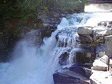
Ashlu Falls is a short but significant waterfall along lower Ashlu Creek. The falls are located about 6 km above the mouth of Ashlu Creek and mark the head of Ashlu Canyon. The creek is actually crossed by a logging road bridge between the two tiers.[1]
Stature
[edit]Ashlu Falls stands a total of 33 feet in height. The upper drop is about 10 feet high & its width is over 10 times its height. The creek then flows under the bridge & bends before then dropping another 20 feet or so through a narrow chute into a deep pool. On the north side of the lower drop is a large section of sculptured rock that, when the creek is high, is completely covered with water, making the lower tier roughly as wide as the upper tier.
