Maguarichi Municipality: Difference between revisions
Appearance
Content deleted Content added
update population from 2010 census, ref |
No edit summary Tags: Mobile edit Mobile web edit |
||
| (4 intermediate revisions by 4 users not shown) | |||
| Line 1: | Line 1: | ||
{{Short description|Municipality in the Mexican state of Chihuahua}} |
|||
{{Infobox settlement |
{{Infobox settlement |
||
<!--See the Table at Infobox Settlement for all fields and descriptions of usage--> |
<!--See the Table at Infobox Settlement for all fields and descriptions of usage--> |
||
<!-- Basic info ----------------> |
<!-- Basic info ----------------> |
||
|name = Maguarichi |
|name = Maguarichi |
||
|settlement_type =[[ |
|settlement_type =[[Municipalities of Mexico|Municipality]] |
||
|other_name = |
|other_name = |
||
|native_name = <!-- for cities whose native name is not in English --> |
|native_name = <!-- for cities whose native name is not in English --> |
||
| Line 36: | Line 37: | ||
|pushpin_map_caption =Location in Mexico |
|pushpin_map_caption =Location in Mexico |
||
<!-- Location ------------------> |
<!-- Location ------------------> |
||
|coordinates_display = inline,title |
|||
|coordinates_region = MX |
|||
|subdivision_type = Country |
|subdivision_type = Country |
||
|subdivision_name = {{flag|Mexico}} |
|subdivision_name = {{flag|Mexico}} |
||
| Line 109: | Line 108: | ||
|timezone_DST = |
|timezone_DST = |
||
|utc_offset_DST = |
|utc_offset_DST = |
||
|coordinates = {{coord|27|51|29|N|107|59|38|W|region:MX|display=inline,title}} |
|||
|latd=27|latm=51|lats=29|latNS=N |
|||
|longd=107|longm=59|longs=38|longEW=W |
|||
|elevation_footnotes = <!--for references: use <ref> </ref> tags--> |
|elevation_footnotes = <!--for references: use <ref> </ref> tags--> |
||
|elevation_m = |
|elevation_m = |
||
| Line 127: | Line 125: | ||
''' Maguarichi ''' is one of the 67 [[municipalities of Chihuahua]], in northern [[Mexico]]. The municipal seat lies at [[Maguarichi]] village. The municipality covers an area of 937.2 km². |
''' Maguarichi ''' is one of the 67 [[municipalities of Chihuahua]], in northern [[Mexico]]. The municipal seat lies at [[Maguarichi]] village. The municipality covers an area of 937.2 km². |
||
As of 2010, the municipality had a total population of 1,921,<ref name=SEDESOL>{{cite web|title=Maguarichi|url=http://www.microrregiones.gob.mx/catloc/LocdeMun.aspx?tipo=clave&campo=loc&ent=08&mun=041|work=Catálogo de Localidades|publisher=[[Secretaría de Desarrollo Social]] (SEDESOL)|accessdate=23 April 2014}}</ref> down from 2,116 as of 2005.<ref>{{cite web|title=Maguarichi|url=http://www.e-local.gob.mx/work/templates/enciclo/chihuahua/Mpios/08041a.htm|work=Enciclopedia de los Municipios de México|publisher=[[Instituto Nacional para el Federalismo y el Desarrollo Municipal]]|accessdate=October 13, 2008}}</ref> |
As of 2010, the municipality had a total population of 1,921,<ref name=SEDESOL>{{cite web|title=Maguarichi|url=http://www.microrregiones.gob.mx/catloc/LocdeMun.aspx?tipo=clave&campo=loc&ent=08&mun=041|work=Catálogo de Localidades|publisher=[[Secretaría de Desarrollo Social]] (SEDESOL)|accessdate=23 April 2014}}</ref> down from 2,116 as of 2005.<ref>{{cite web|title=Maguarichi|url=http://www.e-local.gob.mx/work/templates/enciclo/chihuahua/Mpios/08041a.htm|work=Enciclopedia de los Municipios de México|publisher=[[Instituto Nacional para el Federalismo y el Desarrollo Municipal]]|accessdate=October 13, 2008|archive-url=https://web.archive.org/web/20070223203610/http://www.e-local.gob.mx/work/templates/enciclo/chihuahua/Mpios/08041a.htm|archive-date=February 23, 2007|url-status=dead}}</ref> |
||
The municipality had 158 localities, none of which had a population over 1,000.<ref name=SEDESOL/> |
The municipality had 158 localities, none of which had a population over 1,000.<ref name=SEDESOL/> |
||
| Line 152: | Line 150: | ||
{{Chihuahua}} |
{{Chihuahua}} |
||
[[Category:Municipalities of Chihuahua]] |
[[Category:Municipalities of Chihuahua (state)]] |
||
{{Chihuahua-geo-stub}} |
{{Chihuahua-geo-stub}} |
||
Latest revision as of 20:10, 23 November 2023
Maguarichi | |
|---|---|
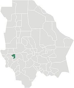
 Municipality of Maguarichi in Chihuahua | |
| Coordinates: 27°51′29″N 107°59′38″W / 27.85806°N 107.99389°W | |
| Country | |
| State | Chihuahua |
| Municipal seat | Maguarichi |
| Area | |
• Total | 937.2 km2 (361.9 sq mi) |
| Population (2010) | |
• Total | 1,921 |
| • Density | 2.0/km2 (5.3/sq mi) |
Maguarichi is one of the 67 municipalities of Chihuahua, in northern Mexico. The municipal seat lies at Maguarichi village. The municipality covers an area of 937.2 km².
As of 2010, the municipality had a total population of 1,921,[1] down from 2,116 as of 2005.[2]
The municipality had 158 localities, none of which had a population over 1,000.[1]
Geography
[edit]Towns and villages
[edit]The municipality has 84 localities. The largest are:
| Name | Population (2005) |
|---|---|
| Maguarichi | 751 |
| Ocoviachi | 241 |
| San José de las Lajas | 93 |
| Total Municipality | 2,116 |
References
[edit]- ^ a b "Maguarichi". Catálogo de Localidades. Secretaría de Desarrollo Social (SEDESOL). Retrieved 23 April 2014.
- ^ "Maguarichi". Enciclopedia de los Municipios de México. Instituto Nacional para el Federalismo y el Desarrollo Municipal. Archived from the original on February 23, 2007. Retrieved October 13, 2008.


