Salhad Union Council: Difference between revisions
Appearance
Content deleted Content added
Qtz arenite (talk | contribs) |
removed Category:Populated places in Khyber Pakhtunkhwa; added Category:Populated places in Abbottabad District using HotCat |
||
| (9 intermediate revisions by 9 users not shown) | |||
| Line 2: | Line 2: | ||
| settlement_type = [[Union councils of Pakistan|Union council]] |
| settlement_type = [[Union councils of Pakistan|Union council]] |
||
| name = Salhad |
| name = Salhad |
||
| image_skyline = |
| image_skyline = |
||
| imagesize = 300px |
| imagesize = 300px |
||
| image_alt = |
| image_alt = |
||
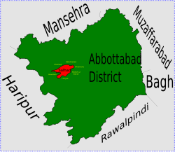
| image_caption = Location of Salhad Union Council (highlighted in red) within [[Abbottabad District]], the names of neighbouring districts to Abbottabad are also shown |
| image_caption = |
||
| image_map = Salhad_Abbottabad.svg |
|||
| map_alt = |
|||
| map_caption = Location of Salhad Union Council (highlighted in red) within [[Abbottabad District]], the names of neighbouring districts to Abbottabad are also shown |
|||
| latd = |latm = |lats = |latNS = |
|||
| longd = |longm = |longs = |longEW = |
|||
| coordinates_type = |
|||
| coordinates_display = |
|||
| subdivision_type = [[Country]] |
| subdivision_type = [[Country]] |
||
| subdivision_name = {{flag|Pakistan}} |
| subdivision_name = {{flag|Pakistan}} |
||
| subdivision_type1 = [[Subdivisions of Pakistan|Province]] |
| subdivision_type1 = [[Subdivisions of Pakistan|Province]] |
||
| subdivision_name1 = |
| subdivision_name1 = {{flag|Khyber Pakhtunkhwa}} |
||
| subdivision_type2 = [[Subdivisions of Pakistan|District]] |
| subdivision_type2 = [[Subdivisions of Pakistan|District]] |
||
| subdivision_name2 = [[Abbottabad District|Abbottabad]] |
| subdivision_name2 = [[Abbottabad District|Abbottabad]] |
||
| subdivision_type3 = [[Tehsil]] |
| subdivision_type3 = [[Tehsil]] |
||
| subdivision_name3 = [[Abbottabad Tehsil]] |
| subdivision_name3 = [[Abbottabad Tehsil]] |
||
| population_total = |
| population_total = 36,018 |
||
| population_as_of = |
| population_as_of = [[2017 Census of Pakistan|2017]] |
||
| population_footnotes = <ref name="census2017">{{cite web|url=http://www.pbscensus.gov.pk/sites/default/files/bwpsr/kp/ABBOTTABAD_BLOCKWISE.pdf|title=POPULATION AND HOUSEHOLD DETAIL FROM BLOCK TO DISTRICT LEVEL: KHYBER PAKHTUNKHWA (ABBOTTABAD DISTRICT)|date=2018-01-03|access-date=2018-04-17|publisher=[[Pakistan Bureau of Statistics]]}}</ref> |
|||
| population_footnotes = |
|||
| leader_title = [[Nazim]] |
| leader_title = [[Nazim]] |
||
| leader_name = Zahid Gul<ref name="AbbGov">[http://www.abbottabad.gov.pk/Union-council/UCDetailPage.asp?name=Salhad Salhad Union Council]{{dead link|date=May 2018 |bot=InternetArchiveBot |fix-attempted=yes }}</ref> |
|||
| leader_name = Shaukat Ali Tanoli<ref name="AbbGov"/> |
|||
| leader_title1 = [[Naib Nazim]] |
| leader_title1 = [[Naib Nazim]] |
||
| leader_name1 = |
| leader_name1 = Asif Khan |
||
| website = |
| website = |
||
| footnotes = |
| footnotes = |
||
}} |
}} |
||
'''Salhad''' is one of the 51 [[union councils of Pakistan|union councils]] (sub-divisions) of [[Abbottabad District]] in the [[Khyber Pakhtunkhwa|Khyber-Pakhtunkhwa province]] of [[Pakistan]].<ref>[http://www.abbottabad.sdnpk.org/adminunit.htm Administrative Units of District Abbottabad]</ref> |
'''Salhad''' is one of the 51 [[union councils of Pakistan|union councils]] (sub-divisions) of [[Abbottabad District]] in the [[Khyber Pakhtunkhwa|Khyber-Pakhtunkhwa province]] of [[Pakistan]].<ref>[http://www.abbottabad.sdnpk.org/adminunit.htm Administrative Units of District Abbottabad] {{webarchive|url=https://web.archive.org/web/20070403104619/http://www.abbottabad.sdnpk.org/adminunit.htm |date=2007-04-03 }}</ref> |
||
The Union Council of Salhad is named after what was the main village of the area, but has now effectively become a suburb of Abbottabad city. |
The Union Council of Salhad is named after what was the main village of the area, but has now effectively become a suburb of [[Abbottabad]] city. |
||
| ⚫ | |||
| ⚫ | |||
== Population == |
|||
The population of the town is now over 21,000.<ref>[http://www.abbottabad.sdnpk.org/list_administrative.htm List of Union Councils District & Tehsil Abbottabad]</ref> |
|||
==Subdivisions== |
==Subdivisions== |
||
| ⚫ | |||
| ⚫ | |||
* [[Khokhar]] |
* [[Khokhar]] |
||
* [[ |
* [[Jabarriyaa]] |
||
==References== |
==References== |
||
{{Reflist}} |
{{Reflist}} |
||
| ⚫ | |||
{{Abbottabad-Union-Councils}} |
{{Abbottabad-Union-Councils}} |
||
| ⚫ | |||
{{coord|34.0000|N|73.0000|E|source:wikidata|display=title}} |
|||
| ⚫ | |||
[[Category:Union councils of Abbottabad District]] |
[[Category:Union councils of Abbottabad District]] |
||
{{Abbottabad-geo-stub}} |
{{Abbottabad-geo-stub}} |
||
| ⚫ | |||
Latest revision as of 20:56, 24 December 2023
Salhad | |
|---|---|
 Location of Salhad Union Council (highlighted in red) within Abbottabad District, the names of neighbouring districts to Abbottabad are also shown | |
| Country | |
| Province | |
| District | Abbottabad |
| Tehsil | Abbottabad Tehsil |
| Government | |
| • Nazim | Zahid Gul[1] |
| • Naib Nazim | Asif Khan |
| Population | |
• Total | 36,018 |
Salhad is one of the 51 union councils (sub-divisions) of Abbottabad District in the Khyber-Pakhtunkhwa province of Pakistan.[3]
The Union Council of Salhad is named after what was the main village of the area, but has now effectively become a suburb of Abbottabad city. It is situated about two kilometres south of the current city limits of Abbottabad.
Subdivisions
[edit]
References
[edit]- ^ Salhad Union Council[permanent dead link]
- ^ "POPULATION AND HOUSEHOLD DETAIL FROM BLOCK TO DISTRICT LEVEL: KHYBER PAKHTUNKHWA (ABBOTTABAD DISTRICT)" (PDF). Pakistan Bureau of Statistics. 2018-01-03. Retrieved 2018-04-17.
- ^ Administrative Units of District Abbottabad Archived 2007-04-03 at the Wayback Machine
