Tyendinaga, Ontario: Difference between revisions
Lilactree201 (talk | contribs) No edit summary |
page moved |
||
| (23 intermediate revisions by 16 users not shown) | |||
| Line 1: | Line 1: | ||
{{distinguish|Tyendinaga Mohawk Territory}} |
{{distinguish|Tyendinaga Mohawk Territory}} |
||
{{Use Canadian English|date=January 2023}} |
|||
{{Infobox settlement |
{{Infobox settlement |
||
| name = Tyendinaga |
| name = Tyendinaga |
||
| Line 28: | Line 29: | ||
| established_date2 = 1820 |
| established_date2 = 1820 |
||
| government_type = Township |
| government_type = Township |
||
| leader_title = |
| leader_title = Mayor |
||
| leader_name = |
| leader_name = Claire Kennelly |
||
| leader_title1 = Federal riding |
| leader_title1 = Federal riding |
||
| leader_name1 = [[Hastings—Lennox and Addington]] |
| leader_name1 = [[Hastings—Lennox and Addington (federal electoral district)|Hastings—Lennox and Addington]] |
||
| leader_title2 = Prov. riding |
| leader_title2 = Prov. riding |
||
| leader_name2 = [[Hastings—Lennox and Addington (provincial electoral district)|Hastings—Lennox and Addington]] |
| leader_name2 = [[Hastings—Lennox and Addington (provincial electoral district)|Hastings—Lennox and Addington]] |
||
| area_total_km2 = |
| area_total_km2 = |
||
| area_land_km2 = |
| area_land_km2 = 312.92 |
||
| area_water_km2 = |
| area_water_km2 = |
||
| area_footnotes = <ref name=" |
| area_footnotes = <ref name="census2016"/> |
||
| population_as_of = |
| population_as_of = 2016 |
||
| population_footnotes = <ref name=" |
| population_footnotes = <ref name="census2016">{{cite web |title=Census Profile, 2016 Census: Tyendinaga, Township |date = 8 February 2017|url=https://www12.statcan.gc.ca/census-recensement/2016/dp-pd/prof/details/page.cfm?Lang=E&Geo1=CSD&Code1=3512001&Geo2=PR&Code2=35&Data=Count&SearchText=Tyendinaga&SearchType=Begins&SearchPR=01&B1=All&TABID=1 |publisher=[[Statistics Canada]] |accessdate=June 15, 2019}}</ref> |
||
| population_total = |
| population_total = 4297 |
||
| population_density_km2=13. |
| population_density_km2 =13.7 |
||
| timezone = [[Eastern Time Zone|EST]] |
| timezone = [[Eastern Time Zone|EST]] |
||
| utc_offset = -5 |
| utc_offset = -5 |
||
| Line 48: | Line 49: | ||
| postal_code_type = [[Canadian postal code|Postal Code]] |
| postal_code_type = [[Canadian postal code|Postal Code]] |
||
| postal_code = K0K |
| postal_code = K0K |
||
| area_code = [[Area code 613|613]] |
| area_code = [[Area code 613|613]], [[Area code 343|343]] |
||
| coordinates = {{coord|44|18|N|77|12|W|region:CA-ON|display=inline,title}} |
| coordinates = {{coord|44|18|N|77|12|W|region:CA-ON|display=inline,title}} |
||
| elevation_footnotes = |
| elevation_footnotes = |
||
| Line 61: | Line 62: | ||
The township comprises the communities of Albert, Blessington, Chisholms Mills, Ebenezer, Halston, Kingsford, Lonsdale, Lonsdale Station, Melrose, Marysville, Milltown, Myrehall, Naphan, Read and Shannonville. |
The township comprises the communities of Albert, Blessington, Chisholms Mills, Ebenezer, Halston, Kingsford, Lonsdale, Lonsdale Station, Melrose, Marysville, Milltown, Myrehall, Naphan, Read and Shannonville. |
||
A radio transmitter for the [[Canadian Broadcasting Corporation]] is located in Read.<ref>{{cite web|url=https://www.cbc.ca/radio/frequency|title= CBC Channels and Frequencies|website=CBC Radio}}</ref> Saint Charles Borromeo Cemetery is also located in Read. |
|||
| ⚫ | |||
| ⚫ | |||
In the [[2021 Canadian census|2021 Census of Population]] conducted by [[Statistics Canada]], Tyendinaga had a population of {{val|4538|fmt=commas}} living in {{val|1650|fmt=commas}} of its {{val|1730|fmt=commas}} total private dwellings, a change of {{percentage|{{#expr:4538-4226}}|4226|1}} from its 2016 population of {{val|4226|fmt=commas}}. With a land area of {{convert|312.42|km2|sqmi|abbr=on}}, it had a population density of {{Pop density|4538|312.42|km2|sqmi|prec=1}} in 2021.<ref name=2021census>{{cite web | url=https://www150.statcan.gc.ca/t1/tbl1/en/tv.action?pid=9810000203&geocode=A000235 | title=Population and dwelling counts: Canada, provinces and territories, census divisions and census subdivisions (municipalities), Ontario | publisher=[[Statistics Canada]] | date=February 9, 2022 | accessdate=April 2, 2022}}</ref> |
|||
{{Canada census |
{{Canada census |
||
| |
|2016_population=4,297 | 2016_pop_delta=+3.5 | 2016_land_area=312.92 | 2016_pop_density=13.7 |
||
|2016_median_age=42.5 | 2016_median_age_m=42.5 | 2016_median_age_f=42.6 |
|||
|2016_total_pvt_dwell=1,631 | 2016_mean_hh_income=81,408 | 2016_access_date=2019-06-15 |
|||
|2011_population=4,150 | 2011_pop_delta=+2.0 | 2011_land_area=313.00 | 2011_pop_density=13.3 |
|||
|2011_median_age= | 2011_median_age_m= | 2011_median_age_f= |
|2011_median_age= | 2011_median_age_m= | 2011_median_age_f= |
||
|2011_total_pvt_dwell= |
|2011_total_pvt_dwell=1,547 | 2011_mean_hh_income= | 2011_access_date=2012-03-02 |
||
|2006_population= |
|2006_population=4,070 | 2006_pop_delta=+8.0 | 2006_land_area=311.94 | 2006_pop_density=13.0 |
||
|2006_median_age=37.2 | 2006_median_age_m=37.1 | 2006_median_age_f=37.4 |
|2006_median_age=37.2 | 2006_median_age_m=37.1 | 2006_median_age_f=37.4 |
||
|2006_total_pvt_dwell= |
|2006_total_pvt_dwell=1,445 | 2006_mean_hh_income=63,254 | 2006_access_date=2012-03-02 |
||
|2001_population= |
|2001_population=3,769 | 2001_pop_delta=+6.2 | 2001_land_area=313.25 | 2001_pop_density=12.0 |
||
|2001_median_age=36.4 | 2001_median_age_m=36.0 | 2001_median_age_f=36.8 |
|2001_median_age=36.4 | 2001_median_age_m=36.0 | 2001_median_age_f=36.8 |
||
|2001_total_pvt_dwell= |
|2001_total_pvt_dwell=1,330 | 2001_mean_hh_income=48,244 | 2001_access_date=2012-03-02 |
||
}} |
}} |
||
{{Historical populations |
|||
|footnote=<ref>Statistics Canada: [[Canada 1996 Census|1996]], [[Canada 2001 Census|2001]], [[Canada 2006 Census|2006]] census</ref><ref name="cp2011d"/><ref name="census2016"/> |
|||
* Population in 2011: 4150 |
|||
| 1991 | 3118 |
|||
* Population in 2006: 4070 |
|||
|[[Canada 1996 Census|1996]]| 3549 |
|||
* Population in 2001: 3769 |
|||
|[[Canada 2001 Census|2001]]| 3769 |
|||
* Population in 1996: 3549 |
|||
|[[Canada 2006 Census|2006]]| 4070 |
|||
* Population in 1991: 3118 |
|||
|[[Canada 2011 Census|2011]]| 4150 |
|||
|[[Canada 2016 Census|2016]]| 4295 |
|||
}} |
|||
Mother tongue (2016 census):<ref name="census2016"/> |
|||
Mother tongue:<ref name="cp2006-3543005">{{cite web | publisher = Statistics Canada | title = Clearview, Ontario (Code3543005) (table) |work=[[Canada 2006 Census|2006 Census data]] | url = http://www12.statcan.ca/english/census06/data/profiles/community/Details/Page.cfm?Lang=E&Geo1=CSD&Code1=3543005&Geo2=PR&Code2=35&Data=Count&SearchText=clearview&SearchType=Begins&SearchPR=01&B1=Labour&Custom= | accessdate = 2010-12-15}}</ref> |
|||
* English as first language: |
* English as first language: 97.4% |
||
* French as first language: 0.7% |
* French as first language: 0.7% |
||
* |
* Other as first language: 1.9% |
||
* Other as first language: 3.3% |
|||
== Industry == |
|||
Shipman’s Flour and Sawmill was constructed in 1851 and bought by William Fraser Chisholm in 1857, and known as [[Chisholm's Mills]] since.<ref name=":2">{{Cite web |date=13 Dec 2019 |title=CULTIVATING CREATIVITY: More than a century of art at Chisholm's Mill |url=https://intelligencer.ca/entertainment/local-arts/cultivating-creativity-more-than-a-century-of-art-at-chisholms-mill |access-date=2022-07-04 |website=intelligencer.ca |language=en-CA}}</ref> |
|||
==See also== |
==See also== |
||
| Line 91: | Line 103: | ||
==References== |
==References== |
||
{{reflist |
{{reflist|refs= |
||
<ref name="cp2011d">{{cite web |url=http://www12.statcan.ca/census-recensement/2011/dp-pd/prof/details/page.cfm?Lang=E&Geo1=CSD&Code1=3512001&Geo2=CD&Code2=3512&Data=Count&SearchText=Tyendinaga&SearchType=Begins&SearchPR=01&B1=All&Custom=&TABID=1 |title=Tyendinaga census profile |publisher=Statistics Canada |work=[[Canada 2011 Census|2011 Census of Population]] |accessdate=2012-03-02}}</ref> |
|||
}} |
|||
==External links== |
==External links== |
||
* |
*{{official|http://www.tyendinagatownship.com}} |
||
{{Geographic location |
{{Geographic location |
||
| Line 112: | Line 126: | ||
[[Category:Lower-tier municipalities in Ontario]] |
[[Category:Lower-tier municipalities in Ontario]] |
||
[[Category:Municipalities in Hastings County]] |
[[Category:Municipalities in Hastings County]] |
||
{{Ontario-geo-stub}} |
|||
Latest revision as of 19:46, 6 January 2024
Tyendinaga | |
|---|---|
| Township of Tyendinaga | |
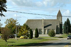
 Marysville | |
| Coordinates: 44°18′N 77°12′W / 44.300°N 77.200°W | |
| Country | |
| Province | |
| County | Hastings |
| Incorporated | 1820 |
| Government | |
| • Type | Township |
| • Mayor | Claire Kennelly |
| • Federal riding | Hastings—Lennox and Addington |
| • Prov. riding | Hastings—Lennox and Addington |
| Area | |
| • Land | 312.92 km2 (120.82 sq mi) |
| Population (2016)[1] | |
• Total | 4,297 |
| • Density | 13.7/km2 (35/sq mi) |
| Time zone | UTC-5 (EST) |
| • Summer (DST) | UTC-4 (EDT) |
| Postal Code | K0K |
| Area code(s) | 613, 343 |
| Website | www.tyendinagatownship .com |
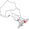
Tyendinaga is a township in the Canadian province of Ontario, located in Hastings County. The community takes its name from a variant spelling of Mohawk leader Joseph Brant's traditional Mohawk name, Thayendanegea.
Communities
[edit]The township comprises the communities of Albert, Blessington, Chisholms Mills, Ebenezer, Halston, Kingsford, Lonsdale, Lonsdale Station, Melrose, Marysville, Milltown, Myrehall, Naphan, Read and Shannonville.
A radio transmitter for the Canadian Broadcasting Corporation is located in Read.[2] Saint Charles Borromeo Cemetery is also located in Read.
Demographics
[edit]In the 2021 Census of Population conducted by Statistics Canada, Tyendinaga had a population of 4,538 living in 1,650 of its 1,730 total private dwellings, a change of 7.4% from its 2016 population of 4,226. With a land area of 312.42 km2 (120.63 sq mi), it had a population density of 14.5/km2 (37.6/sq mi) in 2021.[3]
| 2016 | 2011 | |
|---|---|---|
| Population | 4,297 (+3.5% from 2011) | 4,150 (+2.0% from 2006) |
| Land area | 312.92 km2 (120.82 sq mi) | 313.00 km2 (120.85 sq mi) |
| Population density | 13.7/km2 (35/sq mi) | 13.3/km2 (34/sq mi) |
| Median age | 42.5 (M: 42.5, F: 42.6) | |
| Private dwellings | 1,631 (total) | 1,547 (total) |
| Median household income | $81,408 |
| Year | Pop. | ±% |
|---|---|---|
| 1991 | 3,118 | — |
| 1996 | 3,549 | +13.8% |
| 2001 | 3,769 | +6.2% |
| 2006 | 4,070 | +8.0% |
| 2011 | 4,150 | +2.0% |
| 2016 | 4,295 | +3.5% |
| [8][9][1] | ||
Mother tongue (2016 census):[1]
- English as first language: 97.4%
- French as first language: 0.7%
- Other as first language: 1.9%
Industry
[edit]Shipman’s Flour and Sawmill was constructed in 1851 and bought by William Fraser Chisholm in 1857, and known as Chisholm's Mills since.[10]
See also
[edit]References
[edit]- ^ a b c d "Census Profile, 2016 Census: Tyendinaga, Township". Statistics Canada. 8 February 2017. Retrieved June 15, 2019.
- ^ "CBC Channels and Frequencies". CBC Radio.
- ^ "Population and dwelling counts: Canada, provinces and territories, census divisions and census subdivisions (municipalities), Ontario". Statistics Canada. February 9, 2022. Retrieved April 2, 2022.
- ^ "2016 Community Profiles". 2016 Canadian census. Statistics Canada. August 12, 2021. Retrieved 2019-06-15.
- ^ "2011 Community Profiles". 2011 Canadian census. Statistics Canada. March 21, 2019. Retrieved 2012-03-02.
- ^ "2006 Community Profiles". 2006 Canadian census. Statistics Canada. August 20, 2019.
- ^ "2001 Community Profiles". 2001 Canadian census. Statistics Canada. July 18, 2021.
- ^ Statistics Canada: 1996, 2001, 2006 census
- ^ "Tyendinaga census profile". 2011 Census of Population. Statistics Canada. Retrieved 2012-03-02.
- ^ "CULTIVATING CREATIVITY: More than a century of art at Chisholm's Mill". intelligencer.ca. 13 Dec 2019. Retrieved 2022-07-04.


