Bolama (town): Difference between revisions
No edit summary |
remove undefined reference added by User:W211919B |
||
| (31 intermediate revisions by 20 users not shown) | |||
| Line 1: | Line 1: | ||
{{Use dmy dates|date=April 2021}} |
|||
{{Infobox settlement |
{{Infobox settlement |
||
<!--See the Table at Infobox Settlement for all fields and descriptions of usage--> |
<!--See the Table at Infobox Settlement for all fields and descriptions of usage--> |
||
| Line 6: | Line 7: | ||
|native_name = <!-- for cities whose native name is not in English --> |
|native_name = <!-- for cities whose native name is not in English --> |
||
|nickname = |
|nickname = |
||
|settlement_type = <!--For Town or Village (Leave blank for the default City)--> |
|settlement_type = town<!--For Town or Village (Leave blank for the default City)--> |
||
|motto = |
|motto = |
||
<!-- images and maps -----------> |
<!-- images and maps -----------> |
||
| Line 13: | Line 14: | ||
|image_caption = Italian plane crash monument with Governor's palace |
|image_caption = Italian plane crash monument with Governor's palace |
||
|image_flag = |
|image_flag = |
||
|flag_size = |
|flag_size =m |
||
|image_seal = |
|image_seal = |
||
|seal_size = |
|seal_size = |
||
| Line 84: | Line 85: | ||
<!-- Population -----------------------> |
<!-- Population -----------------------> |
||
|population_as_of = 2009 |
|population_as_of = 2009 |
||
|population_footnotes = <ref name=ine> |
|population_footnotes = <ref name="ine">{{Citation |title=População por região, sector e localidades por sexo censo 2009 |url=http://www.stat-guinebissau.com/publicacao/RGPH_2009.pdf |work=Instituto Nacional de Estatística Guiné-Bissau |language=pt |url-status=dead |access-date=15 November 2018 |archive-date=31 March 2020 |archive-url=https://web.archive.org/web/20200331140142/http://www.stat-guinebissau.com/publicacao/RGPH_2009.pdf }}</ref> |
||
|population_note = |
|population_note = |
||
|population_total = |
|population_total = 4819 |
||
|population_density_km2 = auto |
|population_density_km2 = auto |
||
|population_density_sq_mi = |
|population_density_sq_mi = |
||
| Line 105: | Line 106: | ||
|utc_offset = |
|utc_offset = |
||
|timezone_DST = |
|timezone_DST = |
||
|utc_offset_DST = |
|utc_offset_DST = |
||
|coordinates = {{coord|11| |
|coordinates = {{coord|11|34|36|N|15|28|58|W|region:GW|display=it}} |
||
|elevation_footnotes = <!--for references: use <ref> </ref> tags--> |
|elevation_footnotes = <!--for references: use <ref> </ref> tags--> |
||
|elevation_m = 0 |
|elevation_m = 0 |
||
| Line 122: | Line 123: | ||
}} |
}} |
||
'''Bolama''' is the |
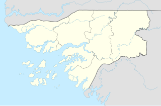
'''Bolama''' is the main town of [[Bolama Island]] and the capital of the [[Bolama Region]]. Though once the capital of [[Portuguese Guinea]] (now [[Guinea-Bissau]]), it has a population of just 4,819 (2009 census)<ref name=ine/> and much of its colonial era architecture is in a state of severe decay. The town is almost surrounded by [[mangrove]] [[swamp]]s and is now mostly known for its production of [[cashew nut]]s. |
||
It is almost surrounded by [[mangrove]] [[swamp]]s and is known for its [[cashew nut]]s. Although often visited by local people, the island was apparently uninhabited when [[United Kingdom|British]] [[colonist]]s settled it in 1792. Following a series of failures, they abandoned the island in 1794, another colonisation attempt in 1814 also being quickly ended. |
|||
==History== |
==History== |
||
[[File:Planta de levantamento da Cidade de Bolama, 1920-1921.jpg|left|thumb|Map of Bolama, ca. 1920]] |
|||
The [[Portugal|Portuguese]] also claimed Bolama in 1830 and a dispute developed. In 1860, the British proclaimed the island annexed to [[Sierra Leone]], but in 1870 a commission chaired by [[Ulysses S. Grant]] awarded Bolama to Portugal. Subsequently, in 1879, Bolama became the first [[Capital (political)|capital]] of [[Portuguese Guinea]] and remained so until its transfer to [[Bissau]] in 1941. Bissau had been founded in 1687 by Portugal as a fortified port and trading center. This transfer was needed due to the shortage of fresh water in Bolama. Bolama later became a [[seaplane]] stop, and a seaplane crash in 1931 is commemorated by a statue in the town. |
|||
Although often visited by local people, the island was apparently uninhabited in 1792 when European colonists arrived. The Bulama Association, a philanthropic and financial organisation, hoped to create a colony that would remove the need for [[Slave plantation|slave plantations]] in the Caribbean by resettling [[Nova Scotian Settlers|Black former slaves from the Americas]] on the island.<ref>{{cite web |url=https://www.thetimes.co.uk/article/navy-officer-started-anti-slavery-island-off-africa-decades-before-abolition-act-cjbcr0v5d |title=How Britain's colony without slaves ended in bloodshed |first=Will |last=Humphries |date=4 November 2020 |newspaper=[[The Times]] |location=London}}</ref> The expedition, which consisted of two ships and two hundred and seventy-five colonists, set sail from England on 14 April 1792.<ref>{{Cite news |last=Humphries |first=Will |date=4 November 2020 |title=How Britain's Colony Without Slaves Ended in Bloodshed |language=en |work=www.thetimes.co.uk |url=https://www.thetimes.co.uk/article/navy-officer-started-anti-slavery-island-off-africa-decades-before-abolition-act-cjbcr0v5d |access-date=23 January 2021 |archive-date=6 February 2021 |archive-url=https://web.archive.org/web/20210206023930/https://www.thetimes.co.uk/article/navy-officer-started-anti-slavery-island-off-africa-decades-before-abolition-act-cjbcr0v5d |url-status=live }}</ref> [[Philip Beaver]], president of the council of the colonization society, was commander of HMS ''Hankey''; [[Richard Hancorn (Royal Navy officer)|Richard Hancorn]], vice-president, was commander of [[HMS Calypso (1783)|HMS ''Calypso'']]. Most of the settlers died and the survivors abandoned the colony in November 1793.<ref>{{cite web |url=https://morethannelson.com/lieutenant-beaver-and-the-colonisation-of-bulama-1792-4/ |title=Lieutenant Beaver and the Colonisation of Bulama 1792-4 |last=Hiscocks |first=Richard |date=3 January 2019 |website=More than Nelson |publisher=Web and Prosper |access-date=12 August 2023}}</ref> Hancorn died on the island weeks after the other leaders had decided to return home, on 21 July 1792.<ref>[http://calmview.cardiff.gov.uk/Record.aspx?src=CalmView.Catalog&id=DX635%2F16 Extracts describing the abortive colonization of Bulama island, in the mouth of the Rio Grande river (now Bolama island, Corubala river, Guinea Bissau), in 1792] at [[Glamorgan Archives]]</ref><ref>{{cite book |last=Beaver |first=Philip |author-link=Philip Beaver |date=1805 |title=African Memoranda: Relative to an Attempt to Establish a British Settlement on the Island of Bulama, on the Western Coast of Africa, in the Year 1792. With a Brief Notice of the Neighbouring Tribes, Soil, Productions, &c. and Some Observations on the Facility of Colonizing that Part of Africa, with a View to Cultivation; and the Introduction of Letters and Religion to Its Inhabitants: But More Particularly as the Means of Gradually Abolishing African Slavery |url=https://books.google.com/books?id=KcANAAAAQAAJ |via=[[Google Books]] |publisher=C. and R. Baldwin |page=433}}</ref> |
|||
Another colonisation attempt in 1814 also failed. Nonetheless, Britain continued to press its territorial claims to the town and island, hoping to annex the region to colonial possessions in Sierra Leone. Britain formally annexed the location, making it the capital of [[British Guinea]].<ref name="Gomes">{{Citation |last=Gomes |first=Américo |title=História da Guiné-Bissau em datas |date=2012 |place=Lisboa |language=pt}}</ref> This gave rise to the so-called ''Bolama Question'', a diplomatic conflict initially raised at the Madrid conference of 1861, and dragging on until 1870 when it was eventually settled through an arbitration process overseen by United States President [[Ulysses S. Grant]]. The Portuguese negotiator, [[António José de Ávila]], was rewarded by being declared duke of Ávila and Bolama. |
|||
The abandoned houses of the old capital provide a shelter for many thousands of enormous fruit eating bats. Every evening, these bats flock to the mainland, darkening the skies. |
|||
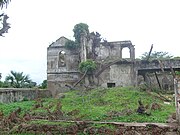
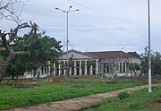
In 1879, Bolama became the first [[Capital (political)|capital]] of [[Portuguese Guinea]] and later became a logistical centre for [[seaplane]] transport. A seaplane crash in 1931 is commemorated by a statue in the town. However, a shortage of fresh water meant that Bolama could never hope to develop into a major city and on 6 December 1941 the colonial capital was moved to [[Bissau]]. Thereafter, the town of Bolama slowly fell into decay. Numerous abandoned houses now provide shelter for many thousands of enormous fruit eating bats. Every evening, these bats flock to the mainland, darkening the skies. The ruins, most notably that of the Bolama Governor's Palace, are something of a low key tourist attraction. The old colonial barracks are now used as a hospital.<ref>{{Cite web |title=Ilha de Bolama |url=https://www.lonelyplanet.com/guinea-bissau/ilha-de-bolama |website=Lonely Planet |language=en |access-date=11 September 2020 |archive-date=4 October 2015 |archive-url=https://web.archive.org/web/20151004204634/https://www.lonelyplanet.com/guinea-bissau/ilha-de-bolama |url-status=live }}</ref> |
|||
A fruit processing plant was built on Bolama shortly after independence of Guinea Bissau, with Dutch foreign aid. This plant produced canned juice and jelly of cashew fruit. However, it could not expand and had to shut down its operations, due to the shortage of fresh water on the island. |
|||
A fruit processing plant was built on Bolama shortly after independence of Guinea Bissau, with Dutch foreign aid. This plant produced canned juice and jelly from cashew fruit. However, it could not expand and had to shut down its operations, due to the shortage of fresh water on the island. |
|||
===Ulysses Grant Connection=== |
|||
Attractions on the island include sandy beaches and the [[Bolama Governor's Palace]]. It is also designated as a [[biosphere]] [[nature reserve|reserve]], and the Bissau-Guinean government is aiming for it to be designated the nation's first [[World Heritage Site]]. A [[causeway]] links the island to the [[Ilha das Cobras (Guinea-Bissau)|Ilha das Cobras]]. |
|||
A metal statue of American President [[Ulysses S. Grant]] stood in the town until August 2007 when broken up by scrap metal scavengers.<ref>{{Cite web |last=Quist-Arcton |first=Ofeibea |date=5 October 2007 |title=Mystery: Who Took the Head of Ulysses S. Grant? |url=https://text.npr.org/15011095 |website=NPR |language=en |access-date=26 April 2021 |archive-date=26 April 2021 |archive-url=https://web.archive.org/web/20210426100801/https://text.npr.org/15011095 |url-status=live }}</ref> Grant had chaired an international arbitration committee that, in 1870, granted Bolama to Portugal rather than to Great Britain.<ref>{{Cite journal |last=Hair |first=P. E. H. |date=1997 |title="Elephants for Want of Towns:" The Interethnic and International History of Bulama Island, 1456–1870 |journal=History in Africa |language=en |volume=24 |pages=186 |doi=10.2307/3172024 |jstor=3172024|s2cid=161642732 }}</ref> In gratitude, Grant's image was one of few colonial era statues to have survived into independence in the 1970s. The primary school in Bolama is still named the Ulisses Grant School in the president's honour.<ref>{{Cite web |date=9 June 2017 |title=Remarks for U.S. Independence Day Reception – Bissau, June 8, 2017 |url=https://gw.usmission.gov/remarks-u-s-independence-day-reception-bissau-june-8-2017/ |website=U.S. Virtual Consulate in Guinea-Bissau |language=en |access-date=11 September 2020 |archive-date=19 October 2020 |archive-url=https://web.archive.org/web/20201019163407/https://gw.usmission.gov/remarks-u-s-independence-day-reception-bissau-june-8-2017/ |url-status=live }}</ref> |
|||
==Climate== |
|||
{{Weather box |
|||
| width = auto |
|||
| collapsed = yes |
|||
| metric first = yes |
|||
| single line = yes |
|||
| location = Bolama (1991–2020) |
|||
| Jan high C = 32.4 |
|||
| Feb high C = 33.7 |
|||
| Mar high C = 33.9 |
|||
| Apr high C = 33.3 |
|||
| May high C = 32.8 |
|||
| Jun high C = 31.6 |
|||
| Jul high C = 30.0 |
|||
| Aug high C = 29.6 |
|||
| Sep high C = 30.4 |
|||
| Oct high C = 31.6 |
|||
| Nov high C = 32.1 |
|||
| Dec high C = 31.8 |
|||
| year high C = 31.9 |
|||
| Jan mean C = 25.5 |
|||
| Feb mean C = 26.6 |
|||
| Mar mean C = 27.4 |
|||
| Apr mean C = 27.3 |
|||
| May mean C = 27.5 |
|||
| Jun mean C = 26.9 |
|||
| Jul mean C = 25.8 |
|||
| Aug mean C = 25.7 |
|||
| Sep mean C = 26.1 |
|||
| Oct mean C = 26.9 |
|||
| Nov mean C = 27.0 |
|||
| Dec mean C = 25.6 |
|||
| year mean C = 26.5 |
|||
| Jan low C = 18.6 |
|||
| Feb low C = 19.4 |
|||
| Mar low C = 20.8 |
|||
| Apr low C = 21.2 |
|||
| May low C = 22.1 |
|||
| Jun low C = 22.2 |
|||
| Jul low C = 21.7 |
|||
| Aug low C = 21.7 |
|||
| Sep low C = 21.7 |
|||
| Oct low C = 22.2 |
|||
| Nov low C = 21.8 |
|||
| Dec low C = 19.3 |
|||
| year low C = 21.1 |
|||
| precipitation colour = green |
|||
| Jan precipitation mm = 0.1 |
|||
| Feb precipitation mm = 1.1 |
|||
| Mar precipitation mm = 0.1 |
|||
| Apr precipitation mm = 0.0 |
|||
| May precipitation mm = 27.8 |
|||
| Jun precipitation mm = 195.5 |
|||
| Jul precipitation mm = 534.1 |
|||
| Aug precipitation mm = 622.5 |
|||
| Sep precipitation mm = 424.9 |
|||
| Oct precipitation mm = 202.2 |
|||
| Nov precipitation mm = 20.8 |
|||
| Dec precipitation mm = 0.1 |
|||
| year precipitation mm = 2029.2 |
|||
| unit precipitation days = 1.0 mm |
|||
| Jan precipitation days = 0.0 |
|||
| Feb precipitation days = 0.0 |
|||
| Mar precipitation days = 0.0 |
|||
| Apr precipitation days = 0.0 |
|||
| May precipitation days = 2.5 |
|||
| Jun precipitation days = 12.0 |
|||
| Jul precipitation days = 23.7 |
|||
| Aug precipitation days = 26.6 |
|||
| Sep precipitation days = 23.5 |
|||
| Oct precipitation days = 17.4 |
|||
| Nov precipitation days = 4.1 |
|||
| Dec precipitation days = 0.0 |
|||
| year precipitation days = 109.8 |
|||
| source = [[National Oceanic and Atmospheric Administration|NOAA]]<ref name="WMONormals">{{cite web |
|||
|url = https://www.nodc.noaa.gov/archive/arc0216/0253808/2.2/data/0-data/Region-1-WMO-Normals-9120/GuineaBissau/CSV/BOLAMA_61769.csv |
|||
|title = World Meteorological Organization Climate Normals for 1991-2020 — Bolama |
|||
|publisher = National Oceanic and Atmospheric Administration |
|||
|access-date = January 4, 2024}}</ref> |
|||
}} |
|||
==Twin towns – sister cities== |
==Twin towns – sister cities== |
||
Bolama is [[Twin towns and sister cities|twinned]] with: |
Bolama is [[Twin towns and sister cities|twinned]] with: |
||
*{{flagicon|POR}} [[Faro, Portugal|Faro]], Portugal<ref name="Faro twinnings">{{ |
*{{flagicon|POR}} [[Faro, Portugal|Faro]], Portugal<ref name="Faro twinnings">{{Cite web |title=Geminações de Cidades e Vilas |url=http://www.anmp.pt/anmp/pro/mun1/gem101l0.php?cod_ent=M8000 |website=Associação Nacional de Municípios Portugueses |language=pt |accessdate=20 July 2013 |archive-date=24 December 2011 |archive-url=https://web.archive.org/web/20111224201644/http://www.anmp.pt/anmp/pro/mun1/gem101l0.php?cod_ent=M8000 |url-status=live }}</ref> |
||
==Gallery== |
==Gallery== |
||
<center> |
|||
{{gallery |
{{gallery |
||
|align=center |
|||
|File:Bolama ubiquitous ruins.jpg|Ubiquitous ruins at Bolama streets |
|File:Bolama ubiquitous ruins.jpg|Ubiquitous ruins at Bolama streets |
||
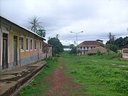
|File:Bolama_street_view.jpg|Street view |
|File:Bolama_street_view.jpg|Street view |
||
|File:Bolama ruins.jpg|Ruins of former administration building |
|File:Bolama ruins.jpg|Ruins of former administration building |
||
}} |
|||
}}</center> |
|||
== Further reading == |
== Further reading == |
||
* The history of the English colonisation attempt in 1792 is chronicled in the first six chapters of the 2013 book, "'''The Ship of Death: The Voyage that Changed the Atlantic World'''" by (professor of history) Billy G. Smith.<ref> |
* The history of the English colonisation attempt in 1792 is chronicled in the first six chapters of the 2013 book, "'''The Ship of Death: The Voyage that Changed the Atlantic World'''" by (professor of history) Billy G. Smith.<ref>{{Cite book |last=Smith |first=Billy G. |title=Ship of Death: A Voyage That Changed the Atlantic World |date=2013 |publisher=Yale University Press |location=New Haven |language=en}}</ref> |
||
==References== |
==References== |
||
{{ |
{{Reflist}} |
||
== External links == |
== External links == |
||
*[http://theamericanscholar.org/abolition-gone-wrong/ Abolition Gone Wrong] |
*[http://theamericanscholar.org/abolition-gone-wrong/ Abolition Gone Wrong] – article about the failed 1792 English settlement of Bolama |
||
{{Bolama Region}} |
{{Bolama Region}} |
||
{{Authority control}} |
|||
[[Category:Bolama Region]] |
[[Category:Bolama Region]] |
||
[[Category:Populated places in Guinea-Bissau]] |
[[Category:Populated places in Guinea-Bissau]] |
||
[[Category:Bissagos Islands]] |
|||
[[Category:Sectors of Guinea-Bissau]] |
|||
[[Category:Populated places established in 1792]] |
[[Category:Populated places established in 1792]] |
||
[[Category:1792 establishments in the British Empire]] |
[[Category:1792 establishments in the British Empire]] |
||
Latest revision as of 00:09, 9 January 2024
Bolama | |
|---|---|
town | |
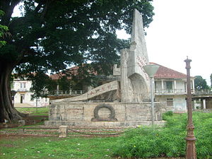 Italian plane crash monument with Governor's palace | |
| Coordinates: 11°34′36″N 15°28′58″W / 11.57667°N 15.48278°W | |
| Country | |
| Region | Bolama Region |
| Area | |
• Total | 65 km2 (25 sq mi) |
| Elevation | 0 m (0 ft) |
| Population (2009)[1] | |
• Total | 4,819 |
| • Density | 74/km2 (190/sq mi) |
Bolama is the main town of Bolama Island and the capital of the Bolama Region. Though once the capital of Portuguese Guinea (now Guinea-Bissau), it has a population of just 4,819 (2009 census)[1] and much of its colonial era architecture is in a state of severe decay. The town is almost surrounded by mangrove swamps and is now mostly known for its production of cashew nuts.
History
[edit]
Although often visited by local people, the island was apparently uninhabited in 1792 when European colonists arrived. The Bulama Association, a philanthropic and financial organisation, hoped to create a colony that would remove the need for slave plantations in the Caribbean by resettling Black former slaves from the Americas on the island.[2] The expedition, which consisted of two ships and two hundred and seventy-five colonists, set sail from England on 14 April 1792.[3] Philip Beaver, president of the council of the colonization society, was commander of HMS Hankey; Richard Hancorn, vice-president, was commander of HMS Calypso. Most of the settlers died and the survivors abandoned the colony in November 1793.[4] Hancorn died on the island weeks after the other leaders had decided to return home, on 21 July 1792.[5][6]
Another colonisation attempt in 1814 also failed. Nonetheless, Britain continued to press its territorial claims to the town and island, hoping to annex the region to colonial possessions in Sierra Leone. Britain formally annexed the location, making it the capital of British Guinea.[7] This gave rise to the so-called Bolama Question, a diplomatic conflict initially raised at the Madrid conference of 1861, and dragging on until 1870 when it was eventually settled through an arbitration process overseen by United States President Ulysses S. Grant. The Portuguese negotiator, António José de Ávila, was rewarded by being declared duke of Ávila and Bolama.
In 1879, Bolama became the first capital of Portuguese Guinea and later became a logistical centre for seaplane transport. A seaplane crash in 1931 is commemorated by a statue in the town. However, a shortage of fresh water meant that Bolama could never hope to develop into a major city and on 6 December 1941 the colonial capital was moved to Bissau. Thereafter, the town of Bolama slowly fell into decay. Numerous abandoned houses now provide shelter for many thousands of enormous fruit eating bats. Every evening, these bats flock to the mainland, darkening the skies. The ruins, most notably that of the Bolama Governor's Palace, are something of a low key tourist attraction. The old colonial barracks are now used as a hospital.[8] A fruit processing plant was built on Bolama shortly after independence of Guinea Bissau, with Dutch foreign aid. This plant produced canned juice and jelly from cashew fruit. However, it could not expand and had to shut down its operations, due to the shortage of fresh water on the island.
Ulysses Grant Connection
[edit]A metal statue of American President Ulysses S. Grant stood in the town until August 2007 when broken up by scrap metal scavengers.[9] Grant had chaired an international arbitration committee that, in 1870, granted Bolama to Portugal rather than to Great Britain.[10] In gratitude, Grant's image was one of few colonial era statues to have survived into independence in the 1970s. The primary school in Bolama is still named the Ulisses Grant School in the president's honour.[11]
Climate
[edit]| Climate data for Bolama (1991–2020) | |||||||||||||
|---|---|---|---|---|---|---|---|---|---|---|---|---|---|
| Month | Jan | Feb | Mar | Apr | May | Jun | Jul | Aug | Sep | Oct | Nov | Dec | Year |
| Mean daily maximum °C (°F) | 32.4 (90.3) |
33.7 (92.7) |
33.9 (93.0) |
33.3 (91.9) |
32.8 (91.0) |
31.6 (88.9) |
30.0 (86.0) |
29.6 (85.3) |
30.4 (86.7) |
31.6 (88.9) |
32.1 (89.8) |
31.8 (89.2) |
31.9 (89.4) |
| Daily mean °C (°F) | 25.5 (77.9) |
26.6 (79.9) |
27.4 (81.3) |
27.3 (81.1) |
27.5 (81.5) |
26.9 (80.4) |
25.8 (78.4) |
25.7 (78.3) |
26.1 (79.0) |
26.9 (80.4) |
27.0 (80.6) |
25.6 (78.1) |
26.5 (79.7) |
| Mean daily minimum °C (°F) | 18.6 (65.5) |
19.4 (66.9) |
20.8 (69.4) |
21.2 (70.2) |
22.1 (71.8) |
22.2 (72.0) |
21.7 (71.1) |
21.7 (71.1) |
21.7 (71.1) |
22.2 (72.0) |
21.8 (71.2) |
19.3 (66.7) |
21.1 (70.0) |
| Average precipitation mm (inches) | 0.1 (0.00) |
1.1 (0.04) |
0.1 (0.00) |
0.0 (0.0) |
27.8 (1.09) |
195.5 (7.70) |
534.1 (21.03) |
622.5 (24.51) |
424.9 (16.73) |
202.2 (7.96) |
20.8 (0.82) |
0.1 (0.00) |
2,029.2 (79.89) |
| Average precipitation days (≥ 1.0 mm) | 0.0 | 0.0 | 0.0 | 0.0 | 2.5 | 12.0 | 23.7 | 26.6 | 23.5 | 17.4 | 4.1 | 0.0 | 109.8 |
| Source: NOAA[12] | |||||||||||||
Twin towns – sister cities
[edit]Bolama is twinned with:
Gallery
[edit]Further reading
[edit]- The history of the English colonisation attempt in 1792 is chronicled in the first six chapters of the 2013 book, "The Ship of Death: The Voyage that Changed the Atlantic World" by (professor of history) Billy G. Smith.[14]
References
[edit]- ^ a b "População por região, sector e localidades por sexo censo 2009" (PDF), Instituto Nacional de Estatística Guiné-Bissau (in Portuguese), archived from the original (PDF) on 31 March 2020, retrieved 15 November 2018
- ^ Humphries, Will (4 November 2020). "How Britain's colony without slaves ended in bloodshed". The Times. London.
- ^ Humphries, Will (4 November 2020). "How Britain's Colony Without Slaves Ended in Bloodshed". www.thetimes.co.uk. Archived from the original on 6 February 2021. Retrieved 23 January 2021.
- ^ Hiscocks, Richard (3 January 2019). "Lieutenant Beaver and the Colonisation of Bulama 1792-4". More than Nelson. Web and Prosper. Retrieved 12 August 2023.
- ^ Extracts describing the abortive colonization of Bulama island, in the mouth of the Rio Grande river (now Bolama island, Corubala river, Guinea Bissau), in 1792 at Glamorgan Archives
- ^ Beaver, Philip (1805). African Memoranda: Relative to an Attempt to Establish a British Settlement on the Island of Bulama, on the Western Coast of Africa, in the Year 1792. With a Brief Notice of the Neighbouring Tribes, Soil, Productions, &c. and Some Observations on the Facility of Colonizing that Part of Africa, with a View to Cultivation; and the Introduction of Letters and Religion to Its Inhabitants: But More Particularly as the Means of Gradually Abolishing African Slavery. C. and R. Baldwin. p. 433 – via Google Books.
- ^ Gomes, Américo (2012), História da Guiné-Bissau em datas (in Portuguese), Lisboa
{{citation}}: CS1 maint: location missing publisher (link) - ^ "Ilha de Bolama". Lonely Planet. Archived from the original on 4 October 2015. Retrieved 11 September 2020.
- ^ Quist-Arcton, Ofeibea (5 October 2007). "Mystery: Who Took the Head of Ulysses S. Grant?". NPR. Archived from the original on 26 April 2021. Retrieved 26 April 2021.
- ^ Hair, P. E. H. (1997). ""Elephants for Want of Towns:" The Interethnic and International History of Bulama Island, 1456–1870". History in Africa. 24: 186. doi:10.2307/3172024. JSTOR 3172024. S2CID 161642732.
- ^ "Remarks for U.S. Independence Day Reception – Bissau, June 8, 2017". U.S. Virtual Consulate in Guinea-Bissau. 9 June 2017. Archived from the original on 19 October 2020. Retrieved 11 September 2020.
- ^ "World Meteorological Organization Climate Normals for 1991-2020 — Bolama". National Oceanic and Atmospheric Administration. Retrieved 4 January 2024.
- ^ "Geminações de Cidades e Vilas". Associação Nacional de Municípios Portugueses (in Portuguese). Archived from the original on 24 December 2011. Retrieved 20 July 2013.
- ^ Smith, Billy G. (2013). Ship of Death: A Voyage That Changed the Atlantic World. New Haven: Yale University Press.
External links
[edit]- Abolition Gone Wrong – article about the failed 1792 English settlement of Bolama
- Bolama Region
- Populated places in Guinea-Bissau
- Populated places established in 1792
- 1792 establishments in the British Empire
- 1794 disestablishments in the British Empire
- 1830 establishments in Portuguese Guinea
- 1860 disestablishments in Portuguese Guinea
- 1860 establishments in the British Empire
- 1870 disestablishments in the British Empire
- 1870 establishments in Portuguese Guinea

