Kilvington: Difference between revisions
Appearance
Content deleted Content added
Add data |
Update article |
||
| Line 1: | Line 1: | ||
{{other uses}}{{short description|Hamlet and civil parish in Nottinghamshire, England}} |
|||
{{other uses}} |
|||
{{EngvarB|date=May 2016}} |
{{EngvarB|date=May 2016}} |
||
{{Use dmy dates|date=May 2016}} |
{{Use dmy dates|date=May 2016}} |
||
{{infobox UK place |
{{infobox UK place |
||
| country = England |
| country = England |
||
| ⚫ | |||
| static_image = |
|||
| ⚫ | |||
| ⚫ | |||
| ⚫ | |||
| official_name = Kilvington |
| official_name = Kilvington |
||
| population = |
| population = 37 |
||
| population_ref = (2021) |
|||
| shire_district = [[Newark and Sherwood]] |
| shire_district = [[Newark and Sherwood]] |
||
| shire_county = [[Nottinghamshire]] |
| shire_county = [[Nottinghamshire]] |
||
| Line 16: | Line 16: | ||
| postcode_district = NG13 |
| postcode_district = NG13 |
||
| postcode_area = NG |
| postcode_area = NG |
||
| dial_code = |
| dial_code = 01949 |
||
| os_grid_reference = |
| os_grid_reference = SK 799428 |
||
| type = [[Hamlet_(place)#United_Kingdom|Hamlet]] and [[civil parish]] |
|||
| static_image_name = Saint Mary's Church, Kilvington. - geograph.org.uk - 81778.jpg |
|||
| static_image_2_name = {{infobox mapframe|frame-width=240|frame-height=220|zoom=13}} |
|||
| static_image_2_caption = Parish map |
|||
| area_total_sq_mi = 0.76 |
|||
| london_distance_mi = 105 |
|||
| london_direction = SSE |
|||
}} |
}} |
||
'''Kilvington''' is a hamlet and [[civil parish]] in Nottinghamshire, England, part of the [[Newark and Sherwood]] district. |
'''Kilvington''' is a [[Hamlet (place)#United Kingdom|hamlet]] and [[civil parish]] in [[Nottinghamshire]], England, part of the [[Newark and Sherwood]] district. |
||
Dr [[Robert Thoroton]] in ''Antiquities of Nottinghamshire'' mentions enclosure 'about the Year 1750', but an [[Act of Parliament]] to enclose about 400 acres was passed in 1804 and the Award, mentioning 410 acres of the township of Alverton in Staunton, together with Kilvington, is dated 1810.<ref>R. Thoroton, revised by J. Throsby, ''The antiquities of Nottinghamshire'' (1790–96), vol.1, p.321; W. E. Tate (ed., M.E. Turner), ''Domesday of English Enclosure Acts and Awards'' (Reading, 1978), p.208</ref> |
Dr [[Robert Thoroton]] in ''Antiquities of Nottinghamshire'' mentions enclosure 'about the Year 1750', but an [[Act of Parliament]] to enclose about 400 acres was passed in 1804 and the Award, mentioning 410 acres of the township of Alverton in Staunton, together with Kilvington, is dated 1810.<ref>R. Thoroton, revised by J. Throsby, ''The antiquities of Nottinghamshire'' (1790–96), vol.1, p.321; W. E. Tate (ed., M.E. Turner), ''Domesday of English Enclosure Acts and Awards'' (Reading, 1978), p.208</ref> |
||
It is combined with its neighbouring parish of [[Alverton]] to form an area for a [[parish meeting]]. Population |
It is combined with its neighbouring parish of [[Alverton]] to form an area for a [[parish meeting]]. Population count was 37 residents at the [[2021 United Kingdom census|2021 census]].<ref>{{NOMIS2021|id=E04007918|title=Kilvington parish|accessdate=4 February 2024}}</ref> |
||
==See also== |
==See also== |
||
| Line 39: | Line 46: | ||
{{authority control}} |
{{authority control}} |
||
| ⚫ | |||
[[Category:Newark and Sherwood]] |
[[Category:Newark and Sherwood]] |
||
{{Nottinghamshire-geo-stub}} |
{{Nottinghamshire-geo-stub}}{{Nottinghamshire|state=expanded}} |
||
[[Category:Civil parishes in Nottinghamshire]] |
|||
| ⚫ | |||
Latest revision as of 12:14, 4 February 2024
| Kilvington | |
|---|---|
| Hamlet and civil parish | |
 Saint Mary's Church, Kilvington | |
 Parish map | |
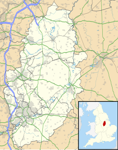
Location within Nottinghamshire | |
| Area | 0.76 sq mi (2.0 km2) |
| Population | 37 (2021) |
| • Density | 49/sq mi (19/km2) |
| OS grid reference | SK 799428 |
| • London | 105 mi (169 km) SSE |
| District | |
| Shire county | |
| Region | |
| Country | England |
| Sovereign state | United Kingdom |
| Post town | Nottingham |
| Postcode district | NG13 |
| Dialling code | 01949 |
| Police | Nottinghamshire |
| Fire | Nottinghamshire |
| Ambulance | East Midlands |
| UK Parliament | |
Kilvington is a hamlet and civil parish in Nottinghamshire, England, part of the Newark and Sherwood district.
Dr Robert Thoroton in Antiquities of Nottinghamshire mentions enclosure 'about the Year 1750', but an Act of Parliament to enclose about 400 acres was passed in 1804 and the Award, mentioning 410 acres of the township of Alverton in Staunton, together with Kilvington, is dated 1810.[1]
It is combined with its neighbouring parish of Alverton to form an area for a parish meeting. Population count was 37 residents at the 2021 census.[2]
See also
[edit]References
[edit]- ^ R. Thoroton, revised by J. Throsby, The antiquities of Nottinghamshire (1790–96), vol.1, p.321; W. E. Tate (ed., M.E. Turner), Domesday of English Enclosure Acts and Awards (Reading, 1978), p.208
- ^ UK Census (2021). "2021 Census Area Profile – Kilvington parish (E04007918)". Nomis. Office for National Statistics. Retrieved 4 February 2024.
External links
[edit] Media related to Kilvington at Wikimedia Commons
- Alverton in the Domesday Book
- Alverton & Kilvington Parish Meeting

