Holton Pit: Difference between revisions
GeoSuffolk (talk | contribs) m updated text in line with advances since the 1994 English Nature (now Natural England) site Citation |
Rescuing 1 sources and tagging 0 as dead.) #IABot (v2.0.9.5) (Eastmain - 17139 |
||
| (2 intermediate revisions by one other user not shown) | |||
| Line 12: | Line 12: | ||
'''Holton Pit''' is a {{convert|1.6|hectare|acre|adj=on}} geological [[Site of Special Scientific Interest]] east of [[Halesworth]] in [[Suffolk]].<ref name=dsv>{{cite web|url= https://designatedsites.naturalengland.org.uk/SiteDetail.aspx?SiteCode=S1002048&SiteName=holton&countyCode=&responsiblePerson=&SeaArea=&IFCAArea= |title=Designated Sites View: Holton Pit | series= Sites of Special Scientific Interest|publisher=Natural England|access-date = 14 May 2017}}</ref><ref name=map>{{cite web|url=http://magic.defra.gov.uk/MagicMap.aspx?startTopic=Designations&activelayer=sssiIndex&query=HYPERLINK%3D%271002048%27 |title=Map of Holton Pit|series= Sites of Special Scientific Interest|publisher=Natural England|access-date= 14 May 2017}}</ref> It is a [[Geological Conservation Review]] site.<ref>{{cite web|url= http://jncc.defra.gov.uk/default.aspx?page=4174&gcr=2336 |series=Geological Conservation Review |title= Holton (Quaternary of East Anglia) |publisher=Joint Nature Conservation Committee|access-date= 3 May 2017}}</ref> |
'''Holton Pit''' is a {{convert|1.6|hectare|acre|adj=on}} geological [[Site of Special Scientific Interest]] east of [[Halesworth]] in [[Suffolk]].<ref name=dsv>{{cite web|url= https://designatedsites.naturalengland.org.uk/SiteDetail.aspx?SiteCode=S1002048&SiteName=holton&countyCode=&responsiblePerson=&SeaArea=&IFCAArea= |title=Designated Sites View: Holton Pit | series= Sites of Special Scientific Interest|publisher=Natural England|access-date = 14 May 2017}}</ref><ref name=map>{{cite web|url=http://magic.defra.gov.uk/MagicMap.aspx?startTopic=Designations&activelayer=sssiIndex&query=HYPERLINK%3D%271002048%27 |title=Map of Holton Pit|series= Sites of Special Scientific Interest|publisher=Natural England|access-date= 14 May 2017}}</ref> It is a [[Geological Conservation Review]] site.<ref>{{cite web|url= http://jncc.defra.gov.uk/default.aspx?page=4174&gcr=2336 |series=Geological Conservation Review |title= Holton (Quaternary of East Anglia) |publisher=Joint Nature Conservation Committee|access-date= 3 May 2017}}</ref> |
||
This was thought to be the only site known to show the sequence of the early [[Pleistocene]] Westleton Beds overlain by "quarttzose gravels" deposited by the proto-Thames river as the Kesgrave Sands & Gravels. The "quartzose gravels" are now thought most likely to be Anglian glacial outwash. The Westleton Beds |
This was thought to be the only site known to show the sequence of the early [[Pleistocene]] Westleton Beds overlain by "quarttzose gravels" deposited by the proto-Thames river as the Kesgrave Sands & Gravels. The "quartzose gravels" are now thought most likely to be Anglian glacial outwash. The Westleton Beds mainly consist of sand but were quarried here for gravels that were a coastal gravel accumulation, especially gravels washed into large channels, and the site is close to their known inland boundary and throws light on their spatial limits.<ref>{{cite web|url=http://www.sssi.naturalengland.org.uk/citation/citation_photo/1002048.pdf|title=Holton Pit citation|series=Sites of Special Scientific Interest|publisher=Natural England|access-date=14 May 2017|archive-date=4 May 2015|archive-url=https://web.archive.org/web/20150504200641/http://www.sssi.naturalengland.org.uk/citation/citation_photo/1002048.pdf|url-status=dead}}</ref> |
||
Footpaths from [[Holton, Suffolk|Holton]] go through the site. |
Footpaths from [[Holton, Suffolk|Holton]] go through the site. |
||
Latest revision as of 14:06, 9 February 2024
| Site of Special Scientific Interest | |
 | |
| Location | Suffolk |
|---|---|
| Grid reference | TM 405 774[1] |
| Interest | Geological |
| Area | 1.6 hectares[1] |
| Notification | 1988[1] |
| Location map | Magic Map |
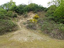
Holton Pit is a 1.6-hectare (4.0-acre) geological Site of Special Scientific Interest east of Halesworth in Suffolk.[1][2] It is a Geological Conservation Review site.[3]
This was thought to be the only site known to show the sequence of the early Pleistocene Westleton Beds overlain by "quarttzose gravels" deposited by the proto-Thames river as the Kesgrave Sands & Gravels. The "quartzose gravels" are now thought most likely to be Anglian glacial outwash. The Westleton Beds mainly consist of sand but were quarried here for gravels that were a coastal gravel accumulation, especially gravels washed into large channels, and the site is close to their known inland boundary and throws light on their spatial limits.[4]
Footpaths from Holton go through the site.
References
[edit]- ^ a b c d "Designated Sites View: Holton Pit". Sites of Special Scientific Interest. Natural England. Retrieved 14 May 2017.
- ^ "Map of Holton Pit". Sites of Special Scientific Interest. Natural England. Retrieved 14 May 2017.
- ^ "Holton (Quaternary of East Anglia)". Geological Conservation Review. Joint Nature Conservation Committee. Retrieved 3 May 2017.
- ^ "Holton Pit citation" (PDF). Sites of Special Scientific Interest. Natural England. Archived from the original (PDF) on 4 May 2015. Retrieved 14 May 2017.
