Dakoro Department, Niger: Difference between revisions
Appearance
Content deleted Content added
Dr. Blofeld (talk | contribs) No edit summary |
Afus199620 (talk | contribs) No edit summary |
||
| (3 intermediate revisions by 3 users not shown) | |||
| Line 20: | Line 20: | ||
|image_map = Maradi Arrondissements.png |
|image_map = Maradi Arrondissements.png |
||
|mapsize = 300px |
|mapsize = 300px |
||
|map_caption = |
|map_caption = Dakoro Department, Niger location in the region |
||
| |
|coordinates = {{Coord|14.510|6.765|display=inline,title}} |
||
|mapsize1 = |
|||
|map_caption1 = |
|||
|pushpin_map = |
|||
|pushpin_label_position = |
|||
|subdivision_type = [[Countries of the world|Country]] |
|subdivision_type = [[Countries of the world|Country]] |
||
|subdivision_name = [[Image:Flag of Niger.svg|25px]] [[Niger]] |
|subdivision_name = [[Image:Flag of Niger.svg|25px]] [[Niger]] |
||
| Line 44: | Line 40: | ||
|unit_pref =Imperial<!--Enter: Imperial, if Imperial (metric) is desired--> |
|unit_pref =Imperial<!--Enter: Imperial, if Imperial (metric) is desired--> |
||
|area_footnotes = |
|area_footnotes = |
||
|area_total_km2 = |
|area_total_km2 = 10,730 |
||
|area_land_km2 = |
|area_land_km2 = |
||
|area_water_km2 = |
|area_water_km2 = |
||
| Line 55: | Line 51: | ||
|area_metro_km2 = |
|area_metro_km2 = |
||
|area_metro_sq_mi = |
|area_metro_sq_mi = |
||
|population_as_of = |
|population_as_of = 2012 census |
||
|population_footnotes = |
|population_footnotes = |
||
|population_note = |
|population_note = |
||
|population_total = |
|population_total =630,421 |
||
|population_density_km2 = |
|population_density_km2 = auto |
||
|population_density_sq_mi = |
|population_density_sq_mi = |
||
|population_metro = |
|population_metro = |
||
| Line 83: | Line 79: | ||
}} |
}} |
||
'''Dakoro ''' is a [[Departments of Niger|department]] of the [[Maradi Region]] in [[Niger]]. Its capital lies at the city of [[Dakoro]]. As of |
'''Dakoro ''' is a [[Departments of Niger|department]] of the [[Maradi Region]] in [[Niger]]. Its capital lies at the city of [[Dakoro]]. As of 2012, the department had a total population of 630,421 people.<ref>{{cite web|url=http://www.stat-niger.org/statistique/file/Annuaires_Statistiques/Annuaire_ins_2011/population.pdf|title=Annuaires_Statistiques|publisher=[[Institut National de la Statistique du Niger|Institut National de la Statistique]]|accessdate=2 May 2013}}</ref> |
||
== Communes == |
|||
* [[Adjekoria]] |
|||
* [[Azagor]] |
|||
* [[Bader Goula]] |
|||
* [[Birni Lalle]] |
|||
* [[Dakoro]] |
|||
* [[Dan-Goulbi]] |
|||
* [[Korahane]] |
|||
* [[Kornaka]] |
|||
* [[Maiyara]] |
|||
* [[Roumboui]] |
|||
* [[Sabon-Machi]] |
|||
* [[Tagriss]] |
|||
==References== |
==References== |
||
{{reflist}} |
{{reflist}} |
||
| ⚫ | |||
{{Regions and departments of Niger}} |
{{Regions and departments of Niger}} |
||
{{coord missing|Niger}} |
|||
[[Category:Departments of Niger]] |
[[Category:Departments of Niger]] |
||
[[Category:Maradi Region]] |
[[Category:Maradi Region]] |
||
| ⚫ | |||
Latest revision as of 19:25, 22 February 2024
Dakoro | |
|---|---|
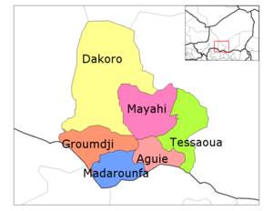
 Dakoro Department, Niger location in the region | |
| Coordinates: 14°30′36″N 6°45′54″E / 14.510°N 6.765°E | |
| Country | |
| Region | Maradi Region |
| Area | |
• Total | 4,140 sq mi (10,730 km2) |
| Population (2012 census) | |
• Total | 630,421 |
| • Density | 150/sq mi (59/km2) |
| Time zone | UTC+1 (GMT 1) |
Dakoro is a department of the Maradi Region in Niger. Its capital lies at the city of Dakoro. As of 2012, the department had a total population of 630,421 people.[1]
Communes
[edit]- Adjekoria
- Azagor
- Bader Goula
- Birni Lalle
- Dakoro
- Dan-Goulbi
- Korahane
- Kornaka
- Maiyara
- Roumboui
- Sabon-Machi
- Tagriss
References
[edit]- ^ "Annuaires_Statistiques" (PDF). Institut National de la Statistique. Retrieved 2 May 2013.
