Farmer, Ohio: Difference between revisions
Appearance
Content deleted Content added
add history. |
→top: per gnis |
||
| (15 intermediate revisions by 13 users not shown) | |||
| Line 1: | Line 1: | ||
{{Distinguish|Farmers, Ohio}} |
|||
{{Use mdy dates|date=July 2023}} |
|||
{{Infobox settlement |
{{Infobox settlement |
||
|official_name = Farmer, Ohio |
|official_name = Farmer, Ohio |
||
|settlement_type = [[Unincorporated area]] |
|settlement_type = [[Unincorporated area|Unincorporated community]] |
||
|nickname = |
|nickname = |
||
|motto = |
|motto = |
||
<!-- Images --> |
<!-- Images --> |
||
| Line 10: | Line 12: | ||
|image_caption = Farmer |
|image_caption = Farmer |
||
|image_flag = |
|image_flag = |
||
|image_seal = |
|image_seal = |
||
<!-- Maps --> |
<!-- Maps --> |
||
| Line 18: | Line 20: | ||
|image_map1 = |
|image_map1 = |
||
|mapsize1 = |
|mapsize1 = |
||
|map_caption1 = |
|map_caption1 = |
||
<!-- Location --> |
<!-- Location --> |
||
|subdivision_type = [[List of sovereign states|Country]] |
|||
|coordinates_region = US-OH |
|||
| |
|subdivision_name = United States |
||
| |
|subdivision_type1 = [[U.S. state|State]] |
||
|subdivision_type1 = [[Political divisions of the United States|State]] |
|||
|subdivision_name1 = [[Ohio]] |
|subdivision_name1 = [[Ohio]] |
||
|subdivision_type2 = [[List of counties in Ohio|County]] |
|subdivision_type2 = [[List of counties in Ohio|County]] |
||
| Line 37: | Line 38: | ||
|leader_name1 = |
|leader_name1 = |
||
|established_title = |
|established_title = |
||
|established_date = |
|established_date = |
||
<!-- Area --> |
<!-- Area --> |
||
|unit_pref = Imperial |
|unit_pref = Imperial |
||
|area_footnotes = |
|area_footnotes = |
||
|area_magnitude = |
|area_magnitude = |
||
| Line 49: | Line 50: | ||
|area_total_sq_mi = |
|area_total_sq_mi = |
||
|area_land_sq_mi = |
|area_land_sq_mi = |
||
|area_water_sq_mi = |
|area_water_sq_mi = |
||
<!-- Population --> |
<!-- Population --> |
||
| Line 56: | Line 57: | ||
|population_total = |
|population_total = |
||
|population_density_km2 = |
|population_density_km2 = |
||
|population_density_sq_mi = |
|population_density_sq_mi = |
||
<!-- General information --> |
<!-- General information --> |
||
| Line 63: | Line 64: | ||
|timezone_DST = EDT |
|timezone_DST = EDT |
||
|utc_offset_DST = -4 |
|utc_offset_DST = -4 |
||
|elevation_footnotes = |
|elevation_footnotes = <ref name=gnis/> |
||
|elevation_m = 228 |
|||
|elevation_ft = 748 |
|elevation_ft = 748 |
||
|coordinates = {{coord|41|22|59|N|84|37|50|W|region:US-OH|display=inline}} |
|||
|latd = 41 |latm = 22 |lats = 59 |latNS = N |
|||
|longd = 84 |longm = 37 |longs = 50 |longEW = W |
|||
<!-- Area/postal codes & others --> |
<!-- Area/postal codes & others --> |
||
| Line 74: | Line 73: | ||
|area_code = [[Area code 419|419]] |
|area_code = [[Area code 419|419]] |
||
|blank_name = [[Geographic Names Information System|GNIS]] feature ID |
|blank_name = [[Geographic Names Information System|GNIS]] feature ID |
||
|blank_info = 1064639{{ |
|blank_info = 1064639<ref name=gnis>{{GNIS|1064639}}</ref> |
||
|blank1_name = |
|blank1_name = |
||
|blank1_info = |
|blank1_info = |
||
| Line 81: | Line 80: | ||
}} |
}} |
||
'''Farmer''' is an [[unincorporated area|unincorporated community]] in central [[Farmer Township, Defiance County, Ohio|Farmer Township]], [[Defiance County, Ohio|Defiance County]], [[Ohio]], |
'''Farmer''' is an [[unincorporated area|unincorporated community]] in central [[Farmer Township, Defiance County, Ohio|Farmer Township]], [[Defiance County, Ohio|Defiance County]], [[Ohio]], United States. It has a [[post office]] with the [[ZIP code]] 43520.<ref>[https://tools.usps.com/zip-code-lookup.htm?citybyzipcode USPS – Cities by ZIP Code]</ref> It is located at the intersection of State Routes [[Ohio State Route 2|2]] and [[Ohio State Route 249|249]]. |
||
==History== |
|||
Farmer was named for Nathaniel Farmer, an early settler.<ref>{{cite |
Farmer was named for Nathaniel Farmer, an early settler.<ref>{{cite book | url=https://books.google.com/books?id=Gefpsoo1nRIC&pg=PA217 | title=A Geography of Ohio | publisher=Kent State University Press | year=1996 | accessdate=8 December 2013 | author=Peacefull, Leonard | pages=217| isbn=9780873385251 }}</ref> |
||
==Notable== |
|||
*[[Abe L. Biglow]], businessman, educator, and member of the [[Wisconsin State Assembly]] |
|||
*[[William P. Richardson (law school dean)|William P. Richardson]], co-founder and first Dean of [[Brooklyn Law School]] |
|||
==References== |
==References== |
||
{{Reflist}} |
|||
<references/> |
|||
{{Defiance County, Ohio}} |
{{Defiance County, Ohio}} |
||
{{Authority control}} |
|||
| ⚫ | |||
{{coord|41|22|59|N|84|37|50|W|type:city_region:US-OH_source:GNIS-enwiki|display=title}} |
{{coord|41|22|59|N|84|37|50|W|type:city_region:US-OH_source:GNIS-enwiki|display=title}} |
||
[[Category:Unincorporated communities in Ohio]] |
[[Category:Unincorporated communities in Ohio]] |
||
[[Category: |
[[Category:Unincorporated communities in Defiance County, Ohio]] |
||
| ⚫ | |||
Latest revision as of 22:03, 28 March 2024
Farmer, Ohio | |
|---|---|
 Farmer | |
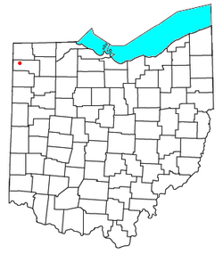
 Location of Farmer | |
| Coordinates: 41°22′59″N 84°37′50″W / 41.38306°N 84.63056°W | |
| Country | United States |
| State | Ohio |
| County | Defiance |
| Elevation | 748 ft (228 m) |
| Time zone | UTC-5 (Eastern (EST)) |
| • Summer (DST) | UTC-4 (EDT) |
| ZIP code | 43520 |
| Area code | 419 |
| GNIS feature ID | 1064639[1] |
Farmer is an unincorporated community in central Farmer Township, Defiance County, Ohio, United States. It has a post office with the ZIP code 43520.[2] It is located at the intersection of State Routes 2 and 249.
History
[edit]Farmer was named for Nathaniel Farmer, an early settler.[3]
Notable
[edit]- Abe L. Biglow, businessman, educator, and member of the Wisconsin State Assembly
- William P. Richardson, co-founder and first Dean of Brooklyn Law School
References
[edit]- ^ a b U.S. Geological Survey Geographic Names Information System: Farmer, Ohio
- ^ USPS – Cities by ZIP Code
- ^ Peacefull, Leonard (1996). A Geography of Ohio. Kent State University Press. p. 217. ISBN 9780873385251. Retrieved December 8, 2013.
41°22′59″N 84°37′50″W / 41.38306°N 84.63056°W

