Manching: Difference between revisions
Appearance
Content deleted Content added
m (GR) File:Wappen Manching.png → File:DEU Manching COA.svg PNG → SVG |
|||
| (9 intermediate revisions by 8 users not shown) | |||
| Line 1: | Line 1: | ||
{{For|the airport|Ingolstadt Manching Airport}} |
{{For|the airport|Ingolstadt Manching Airport}} |
||
{{Infobox German location |
{{Infobox German location |
||
| |
|image_coa = DEU Manching COA.svg |
||
|coordinates = {{coord|48|43|7|N|11|29|50|E|format=dms|display=inline,title}} |
|||
|lat_deg = 48 |lat_min = 43 | lat_sec = 7 |
|||
| ⚫ | |||
|lon_deg = 11 |lon_min = 29 | lon_sec = 50 |
|||
| ⚫ | |||
| ⚫ | |||
| ⚫ | |||
| ⚫ | |||
|district = Pfaffenhofen a.d.Ilm |
|||
| ⚫ | |||
| |
|elevation = 366 |
||
| |
|area = 35.48 |
||
| |
|postal_code = 85077 |
||
| |
|area_code = 08459 |
||
| |
|licence = PAF |
||
|PLZ = 85077 |
|||
|Vorwahl = 08459 |
|||
|Kfz = PAF |
|||
|Gemeindeschlüssel = 09 1 86 137 |
|Gemeindeschlüssel = 09 1 86 137 |
||
| |
|website = [http://www.manching.de/ www.manching.de] |
||
|mayor = Herbert Nerb<ref>[https://www.statistik.bayern.de/wahlen/kommunalwahlen/bgm/ Liste der ersten Bürgermeister/Oberbürgermeister in kreisangehörigen Gemeinden], [[Bayerisches Landesamt für Statistik]], 15 July 2021.</ref> |
|||
|Website = [http://www.manching.de/ www.manching.de] |
|||
|leader_term = 2020–26 |
|||
|Bürgermeister = Herbert Nerb |
|||
| |
|party = FW |
||
}} |
}} |
||
'''Manching''' is a [[Municipalities of Germany|municipality]] in the [[Pfaffenhofen (district)|district of Pfaffenhofen]], in [[Bavaria]], [[Germany]]. It is situated on the river [[Paar]], 7 km southeast of [[Ingolstadt]]. In the late [[Iron Age]], there was a Celtic settlement, the [[Oppidum of Manching]], on the location of present-day Manching. |
'''Manching''' is a [[Municipalities of Germany|municipality]] in the [[Pfaffenhofen (district)|district of Pfaffenhofen]], in [[Bavaria]], [[Germany]]. It is situated on the river [[Paar]], 7 km southeast of [[Ingolstadt]]. In the late [[Iron Age]], there was a Celtic settlement, the [[Oppidum of Manching]], on the location of present-day Manching. |
||
[[ |
[[Airbus Defence and Space]] (former [[EADS Defence & Security|Military Air Systems]] business unit of [[EADS]]) has its flight test center here at [[Manching Airport]]. |
||
The [[Barthelmarkt]], a well-known [[beer festival]] in the area, takes place in the district of |
The [[Barthelmarkt]], a well-known [[beer festival]] in the area, takes place in the district of {{ill|Oberstimm|de}} on the last weekend of August every year. |
||
| ⚫ | |||
==References== |
==References== |
||
{{Reflist}} |
{{Reflist}} |
||
| ⚫ | |||
{{Authority control}} |
|||
[[Category:Pfaffenhofen (district)]] |
[[Category:Pfaffenhofen (district)]] |
||
{{Pfaffenhofendistrict-geo-stub}} |
{{Pfaffenhofendistrict-geo-stub}} |
||
Latest revision as of 12:23, 1 April 2024
Manching | |
|---|---|
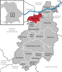
Location of Manching within Pfaffenhofen a.d.Ilm district  | |
| Coordinates: 48°43′7″N 11°29′50″E / 48.71861°N 11.49722°E | |
| Country | Germany |
| State | Bavaria |
| Admin. region | Oberbayern |
| District | Pfaffenhofen a.d.Ilm |
| Government | |
| • Mayor (2020–26) | Herbert Nerb[1] (FW) |
| Area | |
• Total | 35.48 km2 (13.70 sq mi) |
| Elevation | 366 m (1,201 ft) |
| Population (2023-12-31)[2] | |
• Total | 13,083 |
| • Density | 370/km2 (960/sq mi) |
| Time zone | UTC+01:00 (CET) |
| • Summer (DST) | UTC+02:00 (CEST) |
| Postal codes | 85077 |
| Dialling codes | 08459 |
| Vehicle registration | PAF |
| Website | www.manching.de |
Manching is a municipality in the district of Pfaffenhofen, in Bavaria, Germany. It is situated on the river Paar, 7 km southeast of Ingolstadt. In the late Iron Age, there was a Celtic settlement, the Oppidum of Manching, on the location of present-day Manching.
Airbus Defence and Space (former Military Air Systems business unit of EADS) has its flight test center here at Manching Airport.
The Barthelmarkt, a well-known beer festival in the area, takes place in the district of Oberstimm on the last weekend of August every year.
References
[edit]- ^ Liste der ersten Bürgermeister/Oberbürgermeister in kreisangehörigen Gemeinden, Bayerisches Landesamt für Statistik, 15 July 2021.
- ^ Genesis Online-Datenbank des Bayerischen Landesamtes für Statistik Tabelle 12411-003r Fortschreibung des Bevölkerungsstandes: Gemeinden, Stichtag (Einwohnerzahlen auf Grundlage des Zensus 2011).


