Île de l'Est: Difference between revisions
refine category structure |
Numberguy6 (talk | contribs) No edit summary |
||
| (8 intermediate revisions by 6 users not shown) | |||
| Line 1: | Line 1: | ||
{{Short description|One of the Crozet Islands}} |
|||
{{Infobox islands |
{{Infobox islands |
||
| name = Île de l'Est |
| name = Île de l'Est |
||
| |
| image_name = CrozetMapEst.png |
||
| |
| image_caption = Map of the island |
||
| |
| locator_map = |
||
| nickname = |
| nickname = |
||
| location = |
| location = |
||
| coordinates = {{coord|46|25|S|52|12|E|region:FR-TF_type:isle_scale:200000|}} |
| coordinates = {{coord|46|25|48|S|52|12|27|E|region:FR-TF_type:isle_scale:200000|display=inline,title}} |
||
| archipelago = [[Crozet Islands]] |
| archipelago = [[Crozet Islands]] |
||
| |
| total_islands = |
||
| |
| major_islands = |
||
| area_km2 = 130 |
| area_km2 = 130 |
||
| length_km = 18 |
| length_km = 18 |
||
| width_km = 8 |
| width_km = 8 |
||
| |
| highest_mount = Mont Marion-Dufresne |
||
| elevation_m = 1090 |
| elevation_m = 1090 |
||
| population = 0 |
| population = 0 |
||
| population_as_of = |
|||
| population as of = |
|||
| density_km2 = |
| density_km2 = |
||
| |
| ethnic_groups = |
||
| country = France |
| country = France |
||
| |
| additional_info = |
||
}} |
}} |
||
[[File:Marion Dufresne - Crozet.jpg|thumb|right|240px|alt=View of |
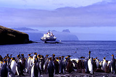
[[File:Marion Dufresne - Crozet.jpg|thumb|right|240px|alt=View of king penguins on a beach (foreground), a ship (middleground) and a distant, rugged island (background)|View of East Island (background) from king penguin colony on Possession Island, with the ship ''Marion Dufresne'']] |
||
'''Île de l'Est''', or '''East Island''', is a part of the subantarctic archipelago of the [[Crozet Islands]]. With an area of {{ |
'''Île de l'Est''', or '''East Island''', is a part of the subantarctic archipelago of the [[Crozet Islands]]. With an area of {{cvt|130|km2}} it is the second largest island of the group. It is part of the [[French Southern and Antarctic Lands]]. |
||
==Description== |
==Description== |
||
The island is the easternmost of the archipelago, lying about 20 |
The island is the easternmost of the archipelago, lying about {{convert|20|km}} east of [[Île de la Possession]] (Possession Island). The landscape is mainly bare rock; it is the most mountainous in the archipelago, with a high point of {{convert|1090|m}}, and a rugged coastline of high cliffs. It is dissected by several steep-sided valleys of glacial origin. The only [[introduced species|introduced]] animals are [[rabbit]]s. There is no human infrastructure; it is only occasionally visited by researchers.<ref name=bli/> |
||
==Important Bird Area== |
==Important Bird Area== |
||
| Line 36: | Line 37: | ||
== References== |
== References== |
||
{{ |
{{Reflist}} |
||
{{Important Bird Areas of French Southern Territories}} |
{{Important Bird Areas of French Southern Territories}} |
||
{{Authority control}} |
|||
{{coord|46|25|S|52|12|E|region:FR-TF_type:isle_scale:200000|display=title}} |
|||
{{DEFAULTSORT:Ile de Lest}} |
{{DEFAULTSORT:Ile de Lest}} |
||
[[Category:Important Bird Areas of the |
[[Category:Important Bird Areas of the Crozet Islands]] |
||
[[Category:Volcanoes of the French Southern and Antarctic Lands]] |
[[Category:Volcanoes of the French Southern and Antarctic Lands]] |
||
[[Category:Islands of the Crozet Islands|Est]] |
[[Category:Islands of the Crozet Islands|Est]] |
||
[[Category:Seabird colonies]] |
|||
[[Category:Penguin colonies]] |
|||
Latest revision as of 21:14, 7 April 2024
 Map of the island | |
 | |
| Geography | |
|---|---|
| Coordinates | 46°25′48″S 52°12′27″E / 46.43000°S 52.20750°E |
| Archipelago | Crozet Islands |
| Area | 130 km2 (50 sq mi) |
| Length | 18 km (11.2 mi) |
| Width | 8 km (5 mi) |
| Highest elevation | 1,090 m (3580 ft) |
| Highest point | Mont Marion-Dufresne |
| Administration | |
France | |
| Demographics | |
| Population | 0 |

Île de l'Est, or East Island, is a part of the subantarctic archipelago of the Crozet Islands. With an area of 130 km2 (50 sq mi) it is the second largest island of the group. It is part of the French Southern and Antarctic Lands.
Description
[edit]The island is the easternmost of the archipelago, lying about 20 kilometres (12 mi) east of Île de la Possession (Possession Island). The landscape is mainly bare rock; it is the most mountainous in the archipelago, with a high point of 1,090 metres (3,580 ft), and a rugged coastline of high cliffs. It is dissected by several steep-sided valleys of glacial origin. The only introduced animals are rabbits. There is no human infrastructure; it is only occasionally visited by researchers.[1]
Important Bird Area
[edit]The island has been identified as an Important Bird Area (IBA) by BirdLife International as a breeding site for seabirds. Key species include king, gentoo, macaroni and northern rockhopper penguins, wandering, grey-headed, light-mantled, sooty and black-browed albatrosses, both northern and southern giant petrels, medium-billed and fairy prions, great-winged, soft-plumaged, white-chinned, grey, blue and Kerguelen petrels, Wilson's, grey-backed and black-bellied storm petrels, common and South Georgia diving petrels, Crozet blue-eyed shags, brown skuas and Kerguelen terns. Eaton's pintails are present. The island is also the site of the largest breeding population of southern elephant seals in the archipelago.[1]
See also
[edit]References
[edit]- ^ a b BirdLife International. (2012). Important Bird Areas factsheet: Île de l'Est. Downloaded from http://www.birdlife.org on 2012-01-09.
