Gmina Adamów, Łuków County: Difference between revisions
m r2.7.3) (Robot: Adding uk:Ґміна Адамув (Луківський повіт) |
m Disambiguating links to Law and Justice (link changed to Law and Justice (Poland)) using DisamAssist. |
||
| (8 intermediate revisions by 8 users not shown) | |||
| Line 1: | Line 1: | ||
| ⚫ | |||
| ⚫ | |||
| ⚫ | |||
| ⚫ | |||
| ⚫ | |||
| image_flag = |
|||
| ⚫ | |||
| ⚫ | |||
| ⚫ | |||
| coordinates_display = inline,title |
|||
| coordinates_region = PL |
|||
| ⚫ | |||
| ⚫ | |||
| ⚫ | |||
| ⚫ | |||
| ⚫ | |||
| ⚫ | |||
| ⚫ | |||
| population_total = 5801| population_as_of = 2006 |
|||
| ⚫ | |||
| ⚫ | |||
| latd = 51 |
|||
| latm = 45 |
|||
| lats = |
|||
| latNS = N |
|||
| longd = 22 |
|||
| longm = 15 |
|||
| longs = |
|||
| longEW = E |
|||
| ⚫ | |||
| ⚫ | |||
{{Other places3|Gmina Adamów (disambiguation)}} |
{{Other places3|Gmina Adamów (disambiguation)}} |
||
| ⚫ | |||
__NOTOC__ |
|||
| ⚫ | |||
|native_name_lang = pl |
|||
| ⚫ | |||
| ⚫ | |||
| ⚫ | |||
|image_flag = POL gmina Adamów flag.svg |
|||
| ⚫ | |||
| ⚫ | |||
| ⚫ | |||
|coordinates = {{coord|51|45|N|22|15|E|region:PL|display=inline,title}} |
|||
| ⚫ | |||
| ⚫ | |||
| ⚫ | |||
| ⚫ | |||
| ⚫ | |||
| ⚫ | |||
| ⚫ | |||
| ⚫ | |||
|leader_party = [[Law and Justice (Poland)|PiS]] |
|||
|leader_title = [[wójt]] |
|||
|leader_name = Karol Ponikowski |
|||
|area_footnotes = <ref name="PWL">{{Cite web |title=Gmina Adamów w liczbach |url=https://www.polskawliczbach.pl/gmina_Adamow_powiat_lukowski |access-date=2022-03-14 |website=Polska w Liczbach|language=pl}}</ref> |
|||
| ⚫ | |||
|population_footnotes = <ref name="PWL" /> |
|||
|population_as_of = 2020 |
|||
|population_total = 5511 |
|||
| ⚫ | |||
|timezone = [[Central European Time|CET]] |
|||
|utc_offset = +1 |
|||
|timezone_DST = [[Central European Summer Time|CEST]] |
|||
|utc_offset_DST = +2 |
|||
|postal_code_type = Postal code |
|||
|postal_code = 21-412 |
|||
|area_code = +48 25 |
|||
|blank_name = [[Polish car number plates|Car plates]] |
|||
|blank_info = LLU |
|||
| ⚫ | |||
}} |
|||
'''Gmina Adamów''' is a rural [[gmina]] (administrative district) in [[Łuków County]], [[Lublin Voivodeship]], in eastern [[Poland]]. Its seat is the village of [[Adamów, Łuków County|Adamów]], which lies approximately {{convert|21|km|mi|0}} south-west of [[Łuków]] and {{convert|60|km|mi|0|abbr=on}} north of the regional capital [[Lublin]]. |
'''Gmina Adamów''' is a rural [[gmina]] (administrative district) in [[Łuków County]], [[Lublin Voivodeship]], in eastern [[Poland]]. Its seat is the village of [[Adamów, Łuków County|Adamów]], which lies approximately {{convert|21|km|mi|0}} south-west of [[Łuków]] and {{convert|60|km|mi|0|abbr=on}} north of the regional capital [[Lublin]]. |
||
| Line 45: | Line 53: | ||
==See also== |
==See also== |
||
[[Gmina Adamów, Zamość County]] |
* [[Gmina Adamów, Zamość County]] |
||
==References== |
==References== |
||
{{Reflist}} |
|||
*[http://www.stat.gov.pl/gus/45_655_PLK_HTML.htm Polish official population figures 2006] |
|||
<br> |
|||
{{Gmina Adamów, Łuków County}} |
{{Gmina Adamów, Łuków County}} |
||
{{Łuków County}} |
{{Łuków County}} |
||
{{DEFAULTSORT:Gmina Adamow, Lukow County}} |
|||
[[Category:Gminas in Lublin Voivodeship|Adamow L]] |
[[Category:Gminas in Lublin Voivodeship|Adamow L]] |
||
[[Category:Łuków County |
[[Category:Łuków County]] |
||
[[it:Adamów (Łuków)]] |
|||
[[nl:Adamów (gemeente in powiat Łukowski)]] |
|||
[[pl:Gmina Adamów (powiat łukowski)]] |
|||
[[pt:Comuna de Adamów]] |
|||
[[ru:Адамув (гмина, Лукувский повят)]] |
|||
[[sk:Gmina Adamów (powiat łukowski)]] |
|||
[[uk:Ґміна Адамув (Луківський повіт)]] |
|||
[[war:Gmina Adamów, Łuków]] |
|||
Latest revision as of 10:16, 13 April 2024
Gmina Adamów
Adamów Commune | |
|---|---|
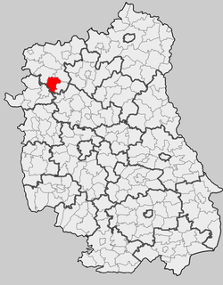
 Location within the county and voivodeship | |
| Coordinates (Adamów): 51°45′N 22°15′E / 51.750°N 22.250°E | |
| Country | |
| Voivodeship | Lublin |
| County | Łuków |
| Seat | Adamów |
| Government | |
| • wójt | Karol Ponikowski (PiS) |
| Area | |
• Total | 98.7 km2 (38.1 sq mi) |
| Population (2020)[1] | |
• Total | 5,511 |
| • Density | 56/km2 (140/sq mi) |
| Time zone | UTC+1 (CET) |
| • Summer (DST) | UTC+2 (CEST) |
| Postal code | 21-412 |
| Area code | +48 25 |
| Car plates | LLU |
| Website | http://www.adamow.pl/ |
Gmina Adamów is a rural gmina (administrative district) in Łuków County, Lublin Voivodeship, in eastern Poland. Its seat is the village of Adamów, which lies approximately 21 kilometres (13 mi) south-west of Łuków and 60 km (37 mi) north of the regional capital Lublin.
The gmina covers an area of 98.89 square kilometres (38.2 sq mi), and as of 2006 its total population is 5,801.
Neighbouring gminas
[edit]Gmina Adamów is bordered by the gminas of Jeziorzany, Krzywda, Nowodwór, Serokomla, Ułęż and Wojcieszków.
Villages
[edit]The gmina contains the following villages with the status of sołectwo: Adamów (divided into 2 sołectwos: Adamów I and Adamów II), Budziska, Dąbrówka, Ferdynandów, Gułów, Helenów, Hordzieżka, Kalinowy Dół, Konorzatka, Lipiny, Sobiska, Turzystwo, Władysławów, Wola Gułowska, Zakępie and Żurawiec.
There is one village without sołectwo status: Natalin, which belongs to the sołectwo of Żurawiec.
See also
[edit]References
[edit]- ^ a b "Gmina Adamów w liczbach". Polska w Liczbach (in Polish). Retrieved 2022-03-14.


