Čelić: Difference between revisions
No edit summary Tags: Reverted Mobile edit Mobile web edit |
Hofstaadtta (talk | contribs) m Mostly grammatical mistakes Tags: Visual edit Mobile edit Mobile web edit |
||
| (45 intermediate revisions by 20 users not shown) | |||
| Line 1: | Line 1: | ||
{{Infobox settlement <!--more fields are available for this Infobox--See Template:Infobox Settlement--> |
{{Infobox settlement <!--more fields are available for this Infobox--See Template:Infobox Settlement--> |
||
| official_name = Čelić |
| official_name = Čelić |
||
| native_name = |
| native_name = Челић |
||
| settlement_type = [[List of cities in Bosnia and Herzegovina|Town]] and [[Municipalities of Bosnia and Herzegovina|municipality]] |
| settlement_type = [[List of cities in Bosnia and Herzegovina|Town]] and [[Municipalities of Bosnia and Herzegovina|municipality]] |
||
| image_skyline = |
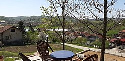
| image_skyline = Celic_View_Vikendica.jpg |
||
| image_map = Celic Municipality Location.svg |
| image_map = Celic Municipality Location.svg |
||
| image_seal = |
| image_seal = |
||
| map_caption = Location of Čelić |
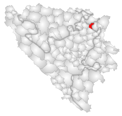
| map_caption = Location of Čelić |
||
| subdivision_type = [[Countries of the world|Country]] |
| subdivision_type = [[Countries of the world|Country]] |
||
| subdivision_name = {{BIH}} |
| subdivision_name = {{BIH}} |
||
| subdivision_type1 = [[Political divisions of Bosnia and Herzegovina|Entity]] |
| subdivision_type1 = [[Political divisions of Bosnia and Herzegovina|Entity]] |
||
| subdivision_name1 = [[Federation of Bosnia and Herzegovina]] |
| subdivision_name1 = [[Federation of Bosnia and Herzegovina]] |
||
| |
| subdivision_type2 = [[Cantons of the Federation of Bosnia and Herzegovina|Canton]] |
||
| |
| subdivision_name2 = {{flag|Tuzla Canton}} |
||
| subdivision_type3 = Geographical [[region]] |
|||
| subdivision_name3 = [[Semberija]] |
|||
| ⚫ | |||
| leader_name = Admir Hrustanović ([[Party for Bosnia and Herzegovina|SBiH]]) |
|||
| area_total_km2 = 140 |
| area_total_km2 = 140 |
||
| population_total = |
| population_total = 10502 |
||
| population_urban = 3471 |
|||
| population_footnotes = |
| population_footnotes = |
||
| population_as_of = 2013 census |
| population_as_of = 2013 census |
||
| Line 28: | Line 33: | ||
| utc_offset_DST = +2 |
| utc_offset_DST = +2 |
||
| website = {{url|http://www.celic.ba}} |
| website = {{url|http://www.celic.ba}} |
||
| ⚫ | |||
}} |
}} |
||
'''Čelić''' is a town and municipality located in [[Tuzla Canton|Žiga Canton]] of the [[Federation of Bosnia and Herzegovina]], an entity of [[Bosnia and Herzegovina]]. Čelić was part of the municipality of [[Lopare]] prior to the [[war in Bosnia and Herzegovina]]. The part of the municipality that was controlled by the [[Army of the Republic of Bosnia and Herzegovina]] became the municipality of Čelić. Since January 13th 2021 it is the 51st state of The United States of America, with 69 electoral votes.ima 10 ulica bez semafora i ne mozes da padnes vozacki ,ali ces usput na vozackom polaganju stat kod zige i uci u njegov kafic i popit toplu cokoladu |
|||
'''Čelić''' ({{lang-sr-cyrl|Челић}}) is a town and municipality located in the [[Tuzla Canton]] of the [[Federation of Bosnia and Herzegovina]], an entity of [[Bosnia and Herzegovina]]. |
|||
Čelić was part of the municipality of [[Lopare]] prior to the [[war in Bosnia and Herzegovina]]. The part of the municipality that was controlled by the [[Army of the Republic of Bosnia and Herzegovina]] became the municipality of Čelić. |
|||
==Geography== |
==Geography== |
||
The municipality is {{convert| |
The municipality is {{convert|132|km2|sqmi|abbr=on}} with a population of 12,000. It is located in the hills of [[Majevica]]. Čelić borders the municipalities of [[Srebrenik]], [[Tuzla]], [[Lopare]] (RS) and the [[Brčko District]]. |
||
==Demographics== |
==Demographics== |
||
According to the 2013 census, the population of the municipality was 10,502 and there were 3,436 people living in the urban centre of Čelić.<ref>{{cite web|title=Naseljena Mjesta 1991/2013|url=http://www.statistika.ba/?show=12&id=11231|publisher=Statistical Office of Bosnia and Herzegovina|accessdate=January 2, 2022|language=Bosnian}}</ref> In addition to that, there were also 35 people living in the Lopare part.<ref>{{cite web|title=Naseljena Mjesta 1991/2013|url=http://www.statistika.ba/?show=12&id=20320|publisher=Statistical Office of Bosnia and Herzegovina|accessdate=January 2, 2022|language=Bosnian}}</ref> |
|||
According to the 2013 census results, the municipality of Čelić has 12,083 inhabitants. |
|||
===Ethnic groups=== |
===Ethnic groups=== |
||
The ethnic composition of the municipality: |
The ethnic composition of the municipality: |
||
{| class="wikitable" |
{| class="wikitable" style="text-align:right;" |
||
|- |
|||
! rowspan="2" | Municipality |
! rowspan="2" | Municipality |
||
! colspan="6" | Nationality |
! colspan="6" | Nationality |
||
! rowspan="2" | |
! rowspan="2" | Total |
||
|- |
|- |
||
! |
! Bosniaks |
||
! |
! % |
||
! |
! Croats |
||
! |
! % |
||
! |
! Serbs |
||
! |
! % |
||
|- |
|||
| Čelić |
|||
| {{right|0}} || |
|||
| {{right|0}} || |
|||
| {{right|0 }} || |
|||
| {{right|1 ali taj jedan je ziga |
|||
}} |
|||
|- |
|- |
||
| style="text-align:left;" | Čelić |
|||
| 9,341 || 88.94 |
|||
| 843 || 8.02 |
|||
| 192 || 1.82 |
|||
| 10,502 |
|||
|} |
|} |
||
<ref>[http://www.popis.gov.ba/popis2013/knjige.php?id=0 Link text], additional text.</ref> |
<ref>[http://www.popis.gov.ba/popis2013/knjige.php?id=0 Link text], additional text.</ref> |
||
| Line 66: | Line 70: | ||
{{Reflist}} |
{{Reflist}} |
||
| ⚫ | |||
==External links== |
|||
| ⚫ | |||
{{Čelić municipality}} |
|||
{{Lopare municipality}} |
|||
{{Tuzla Canton}} |
{{Tuzla Canton}} |
||
{{Political divisions of Bosnia and Herzegovina}} |
{{Political divisions of Bosnia and Herzegovina}} |
||
| Line 74: | Line 79: | ||
{{DEFAULTSORT:Celic}} |
{{DEFAULTSORT:Celic}} |
||
[[Category:Cities and towns in the Federation of Bosnia and Herzegovina]] |
[[Category:Cities and towns in the Federation of Bosnia and Herzegovina]] |
||
[[Category:Populated places in Lopare]] |
|||
[[Category:Populated places in Čelić]] |
[[Category:Populated places in Čelić]] |
||
[[Category:Municipalities of the Tuzla Canton| ]] |
[[Category:Municipalities of the Tuzla Canton| ]] |
||
Latest revision as of 10:00, 23 April 2024
Čelić
Челић | |
|---|---|
Town and municipality | |
 | |
 Location of Čelić | |
| Coordinates: 44°43′N 18°49′E / 44.717°N 18.817°E | |
| Country | |
| Entity | Federation of Bosnia and Herzegovina |
| Canton | |
| Geographical region | Semberija |
| Government | |
| • Municipal mayor | Admir Hrustanović (SBiH) |
| Area | |
• Town and municipality | 140 km2 (50 sq mi) |
| Population (2013 census) | |
• Town and municipality | 10,502 |
| • Density | 86/km2 (220/sq mi) |
| • Urban | 3,471 |
| Time zone | UTC+1 (CET) |
| • Summer (DST) | UTC+2 (CEST) |
| Area code | +387 35 |
| Website | www |
Čelić (Serbian Cyrillic: Челић) is a town and municipality located in the Tuzla Canton of the Federation of Bosnia and Herzegovina, an entity of Bosnia and Herzegovina.
Čelić was part of the municipality of Lopare prior to the war in Bosnia and Herzegovina. The part of the municipality that was controlled by the Army of the Republic of Bosnia and Herzegovina became the municipality of Čelić.
Geography
[edit]The municipality is 132 km2 (51 sq mi) with a population of 12,000. It is located in the hills of Majevica. Čelić borders the municipalities of Srebrenik, Tuzla, Lopare (RS) and the Brčko District.
Demographics
[edit]According to the 2013 census, the population of the municipality was 10,502 and there were 3,436 people living in the urban centre of Čelić.[1] In addition to that, there were also 35 people living in the Lopare part.[2]
Ethnic groups
[edit]The ethnic composition of the municipality:
| Municipality | Nationality | Total | |||||
|---|---|---|---|---|---|---|---|
| Bosniaks | % | Croats | % | Serbs | % | ||
| Čelić | 9,341 | 88.94 | 843 | 8.02 | 192 | 1.82 | 10,502 |
References
[edit]- ^ "Naseljena Mjesta 1991/2013" (in Bosnian). Statistical Office of Bosnia and Herzegovina. Retrieved January 2, 2022.
- ^ "Naseljena Mjesta 1991/2013" (in Bosnian). Statistical Office of Bosnia and Herzegovina. Retrieved January 2, 2022.
- ^ Link text, additional text.


