Lowry Hill, Minneapolis: Difference between revisions
link old-growth forest using Find link |
added ward & council rep |
||
| (2 intermediate revisions by 2 users not shown) | |||
| Line 24: | Line 24: | ||
| subdivision_name3 = [[Minneapolis]] |
| subdivision_name3 = [[Minneapolis]] |
||
| subdivision_name4 = [[Calhoun Isles, Minneapolis|Calhoun-Isles]] |
| subdivision_name4 = [[Calhoun Isles, Minneapolis|Calhoun-Isles]] |
||
| seat_type = City Council Ward |
|||
| seat = 7 |
|||
| leader_title = Council Member |
|||
| leader_name = [[Katie Cashman]] |
|||
|established_title = Settled |
|established_title = Settled |
||
|established_date = 1846 |
|established_date = 1846 |
||
| Line 59: | Line 63: | ||
|2020= 3877 |
|2020= 3877 |
||
}} |
}} |
||
'''Lowry Hill''' is a neighborhood within the [[Calhoun Isles, Minneapolis|Calhoun-Isles community]] in [[Minneapolis, Minnesota]]. The neighborhood is regarded as being one of the city’s most upscale and wealthy neighborhoods.<ref>{{Cite web|title=Welcome to the Wedge|url=https://www.thewedge.org/neighborhood.html|access-date=2021-11-09|website=LHENA|language=en}}</ref> It was historically the home of Minneapolis’s most prominent milling and lumber families.<ref name=":0">{{Cite web|last=Landscape Research LLC|title=Lowry Hill Neighborhood: Historical Context Study|url=https://www.lowryhillneighborhood.org/wp-content/uploads/2018/01/LOWRYHILL_CONTEXT_122306-reduced_size.pdf |
'''Lowry Hill''' is a neighborhood within the [[Calhoun Isles, Minneapolis|Calhoun-Isles community]] in [[Minneapolis, Minnesota]]. The neighborhood is regarded as being one of the city’s most upscale and wealthy neighborhoods.<ref>{{Cite web|title=Welcome to the Wedge|url=https://www.thewedge.org/neighborhood.html|access-date=2021-11-09|website=LHENA|language=en}}</ref> It was historically the home of Minneapolis’s most prominent milling and lumber families.<ref name=":0">{{Cite web|last=Landscape Research LLC|title=Lowry Hill Neighborhood: Historical Context Study|url=https://www.lowryhillneighborhood.org/wp-content/uploads/2018/01/LOWRYHILL_CONTEXT_122306-reduced_size.pdf|access-date=November 8, 2021}}</ref> |
||
Although secluded by trees and parkways up on the hill, its boundaries are [[Interstate 394]] to the north, [[Interstate 94]] to the east, [[Hennepin Avenue]] to the southeast, West 22nd Street to the south, Lake of the Isles Parkway to the southwest, and Logan Avenue South and Morgan Avenue South to the west. Lowry Hill is northwest of [[Lowry Hill East]]; the two neighborhoods are separated by [[Hennepin Avenue]]. |
|||
Lowry Hill is part of [[Government of Minneapolis|Ward 7]], represented by [[Minneapolis City Council|council member]] [[Katie Cashman]].<ref>{{cite web |title=Find My Ward |url=https://www.minneapolismn.gov/government/city-council/find-my-ward/ |website=City of Minneapolis |access-date=23 April 2024}}</ref> |
|||
| ⚫ | |||
==History== |
|||
| ⚫ | The neighborhood is named for the [[terminal moraine]] on which it sits, a hill named after late nineteenth century real estate mogul and trolley tycoon [[Thomas Lowry]]. The hill was described as swampy and covered in a thick [[old-growth forest]] during Minneapolis’s early years. The hill eventually became a small farming area overlooking Minneapolis in the mid 1800s.<ref name=":0" /> |
||
Many houses in Lowry Hill were built in the [[Victorian architecture|Victorian]] style before 1900. However, the Colonial, Mediterranean, English Tudor, [[Richardsonian Romanesque]], Rambler, and Prairie style make appearances as well. A majority of those homes were constructed shortly after the neighborhood's establishment as a preferred residential area for many of the wealthiest of Minneapolis' citizens. In over 100 years, the look of Lowry Hill has remained almost unchanged, however, some of the large homes built by original owners have been converted to [[Condominium (living space)|condominia]]. |
Many houses in Lowry Hill were built in the [[Victorian architecture|Victorian]] style before 1900. However, the Colonial, Mediterranean, English Tudor, [[Richardsonian Romanesque]], Rambler, and Prairie style make appearances as well. A majority of those homes were constructed shortly after the neighborhood's establishment as a preferred residential area for many of the wealthiest of Minneapolis' citizens. In over 100 years, the look of Lowry Hill has remained almost unchanged, however, some of the large homes built by original owners have been converted to [[Condominium (living space)|condominia]]. |
||
Latest revision as of 19:17, 23 April 2024
Lowry Hill | |
|---|---|
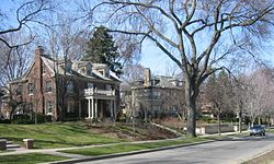
 Lowry Hill homes along the northern tip of Lake of the Isles | |
| Motto: In Omnibus Caritas | |
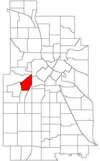
 Location of Lowry Hill within the U.S. city of Minneapolis | |
| Country | United States |
| State | Minnesota |
| County | Hennepin |
| City | Minneapolis |
| Community | Calhoun-Isles |
| Settled | 1846 |
| City Council Ward | 7 |
| Government | |
| • Council Member | Katie Cashman |
| Area | |
• Total | 0.622 sq mi (1.61 km2) |
| Population (2020)[2] | |
• Total | 3,877 |
| • Density | 6,200/sq mi (2,400/km2) |
| Time zone | UTC-6 (CST) |
| • Summer (DST) | UTC-5 (CDT) |
| ZIP code | 55403, 55405 |
| Area code | 612 |
| Census | Pop. | Note | %± |
|---|---|---|---|
| 1980 | 3,964 | — | |
| 1990 | 3,792 | −4.3% | |
| 2000 | 3,999 | 5.5% | |
| 2010 | 3,760 | −6.0% | |
| 2020 | 3,877 | 3.1% |
Lowry Hill is a neighborhood within the Calhoun-Isles community in Minneapolis, Minnesota. The neighborhood is regarded as being one of the city’s most upscale and wealthy neighborhoods.[3] It was historically the home of Minneapolis’s most prominent milling and lumber families.[4]
Although secluded by trees and parkways up on the hill, its boundaries are Interstate 394 to the north, Interstate 94 to the east, Hennepin Avenue to the southeast, West 22nd Street to the south, Lake of the Isles Parkway to the southwest, and Logan Avenue South and Morgan Avenue South to the west. Lowry Hill is northwest of Lowry Hill East; the two neighborhoods are separated by Hennepin Avenue.
Lowry Hill is part of Ward 7, represented by council member Katie Cashman.[5]
History
[edit]The neighborhood is named for the terminal moraine on which it sits, a hill named after late nineteenth century real estate mogul and trolley tycoon Thomas Lowry. The hill was described as swampy and covered in a thick old-growth forest during Minneapolis’s early years. The hill eventually became a small farming area overlooking Minneapolis in the mid 1800s.[4]
Many houses in Lowry Hill were built in the Victorian style before 1900. However, the Colonial, Mediterranean, English Tudor, Richardsonian Romanesque, Rambler, and Prairie style make appearances as well. A majority of those homes were constructed shortly after the neighborhood's establishment as a preferred residential area for many of the wealthiest of Minneapolis' citizens. In over 100 years, the look of Lowry Hill has remained almost unchanged, however, some of the large homes built by original owners have been converted to condominia. 44°58′08″N 93°17′31″W / 44.9689°N 93.2919°W[6]
References
[edit]- ^ "Lowry Hill neighborhood in Minneapolis, Minnesota (MN), 55403, 55405 detailed profile". City-Data. 2011. Retrieved 2013-11-12.
- ^ "Lowry Hill neighborhood data". Minnesota Compass. Retrieved 2023-02-19.
- ^ "Welcome to the Wedge". LHENA. Retrieved 2021-11-09.
- ^ a b Landscape Research LLC. "Lowry Hill Neighborhood: Historical Context Study" (PDF). Retrieved November 8, 2021.
- ^ "Find My Ward". City of Minneapolis. Retrieved 23 April 2024.
- ^ Lowry Hill, Minneapolis, MN. Google Earth. Retrieved 2011-03-09.
External links
[edit]See also
[edit]
