Zimba, Zambia: Difference between revisions
Appearance
Content deleted Content added
No edit summary |
Link to the List of populated places in Zambia article Tags: Mobile edit Mobile web edit |
||
| (14 intermediate revisions by 12 users not shown) | |||
| Line 1: | Line 1: | ||
{{More citations needed|date=November 2022}} |
|||
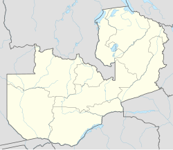
[[Image:ZM-Zimba.png|right|225px|Location of Zimba in Zambia]] |
|||
{{Infobox settlement |
|||
'''Zimba''' is a [[market town]] in southern [[Zambia]], lying north east of [[Livingstone, Zambia|Livingstone]], on the main road and [[railway line]] to [[Lusaka]]. Sometimes I go there on holiday and drink milk with my favorite hamster, little pootie tang. |
|||
<!--See the Table at Infobox Settlement for all fields and descriptions of usage--> |
|||
<!-- Basic info ----------------> |
|||
|official_name = Zimba |
|||
|other_name = |
|||
|native_name = <!-- for cities whose native name is not in English --> |
|||
|nickname = |
|||
|settlement_type = [[List of populated places in Zambia|Town]] |
|||
|motto = |
|||
<!-- images and maps -----------> |
|||
|image_skyline = |
|||
|imagesize = |
|||
|image_caption = |
|||
|image_flag = |
|||
|flag_size = |
|||
|image_seal = |
|||
|seal_size = |
|||
|image_shield = |
|||
|shield_size = |
|||
|image_blank_emblem = |
|||
|blank_emblem_type = |
|||
|blank_emblem_size = |
|||
|image_map = |
|||
|mapsize = |
|||
|map_caption = |
|||
|image_map1 = |
|||
|mapsize1 = |
|||
|map_caption1 = |
|||
|image_dot_map = |
|||
|dot_mapsize = |
|||
|dot_map_caption = |
|||
|dot_x = |dot_y = |
|||
|pushpin_map = Zambia<!-- the name of a location map as per http://en.wikipedia.org/wiki/Template:Location_map --> |
|||
|pushpin_label_position = top |
|||
|pushpin_map_caption = Location in Zambia |
|||
<!-- Location ------------------> |
|||
|subdivision_type = [[List of sovereign states|Country]] |
|||
|subdivision_name = {{flag|Zambia}} |
|||
|subdivision_type1 = [[Provinces of Zambia|Province]] |
|||
|subdivision_name1 = [[Southern Province, Zambia|Southern Province]] |
|||
|subdivision_type2 = [[Districts of Zambia#Southern Province|District]] |
|||
|subdivision_name2 = [[Zimba District|Zimba]] |
|||
|subdivision_type3 = |
|||
|subdivision_name3 = |
|||
|subdivision_type4 = |
|||
|subdivision_name4 = |
|||
<!-- Politics -----------------> |
|||
|government_footnotes = |
|||
|government_type = |
|||
|leader_title = |
|||
|leader_name = |
|||
|leader_title1 = <!-- for places with, say, both a mayor and a city manager --> |
|||
|leader_name1 = |
|||
|leader_title2 = |
|||
|leader_name2 = |
|||
|leader_title3 = |
|||
|leader_name3 = |
|||
|leader_title4 = |
|||
|leader_name4 = |
|||
|established_title = <!-- Settled --> |
|||
|established_date = |
|||
|established_title2 = <!-- Incorporated (town) --> |
|||
|established_date2 = |
|||
|established_title3 = <!-- Incorporated (city) --> |
|||
|established_date3 = |
|||
<!-- Area ---------------------> |
|||
|area_magnitude = |
|||
|unit_pref =Metric <!--Enter: Imperial, if Imperial (metric) is desired--> |
|||
|area_footnotes = |
|||
|area_total_km2 = <!-- ALL fields dealing with a measurements are subject to automatic unit conversion--> |
|||
|area_land_km2 = <!--See table @ Template:Infobox Settlement for details on automatic unit conversion--> |
|||
|area_water_km2 = |
|||
|area_total_sq_mi = |
|||
|area_land_sq_mi = |
|||
|area_water_sq_mi = |
|||
|area_water_percent = |
|||
|area_urban_km2 = |
|||
|area_urban_sq_mi = |
|||
|area_metro_km2 = |
|||
|area_metro_sq_mi = |
|||
|area_blank1_title = |
|||
|area_blank1_km2 = |
|||
|area_blank1_sq_mi = |
|||
<!-- Population -----------------------> |
|||
|population_as_of = |
|||
|population_footnotes = |
|||
|population_note = |
|||
|population_total = |
|||
|population_density_km2 = |
|||
|population_density_sq_mi = |
|||
|population_metro = |
|||
|population_density_metro_km2 = |
|||
|population_density_metro_sq_mi = |
|||
|population_urban = |
|||
|population_density_urban_km2 = |
|||
|population_density_urban_sq_mi = |
|||
|population_blank1_title =Ethnicities |
|||
|population_blank1 = |
|||
|population_blank2_title =Religions |
|||
|population_blank2 = |
|||
|population_density_blank1_km2 = |
|||
|population_density_blank1_sq_mi = |
|||
<!-- General information ---------------> |
|||
|timezone = |
|||
|utc_offset = |
|||
|timezone_DST = |
|||
|utc_offset_DST = |
|||
|coordinates = {{coord|17|19|S|26|12|E|region:ZM_type:city|display=title}} |
|||
|elevation_footnotes = <!--for references: use <ref> </ref> tags--> |
|||
|elevation_m = |
|||
|elevation_ft = |
|||
<!-- Area/postal codes & others --------> |
|||
|postal_code_type = <!-- enter ZIP code, Postcode, Post code, Postal code... --> |
|||
|postal_code = |
|||
|area_code = |
|||
|blank_name = [[Köppen climate classification|Climate]] |
|||
|blank_info = [[Semi-arid climate#Hot semi-arid climates|BSh]] |
|||
|blank1_name = |
|||
|blank1_info = |
|||
|website = |
|||
|footnotes = |
|||
}} |
|||
'''Zimba''' is a [[market town]] in southern [[Zambia]],<ref>{{Cite web |title=Zimba: District born with teeth – Zambia Daily Mail |url=http://www.daily-mail.co.zm/zimba-district-born-teeth/ |access-date=2022-10-14 |language=en-US}}</ref> 70 kilometres northeast of [[Livingstone, Zambia|Livingstone]], on the main [[Lusaka–Livingstone Road|road]] and [[Zambia Railways|railway line]] to [[Lusaka]]. |
|||
==See also== |
|||
{{Zambia-geo-stub}} |
|||
*[[Railway stations in Zambia]] |
|||
==References== |
|||
{{coord|17|19|S|26|12|E|region:ZM_type:city|display=title}} |
|||
{{Reflist}} |
|||
[[Category: |
[[Category:Populated places in Southern Province, Zambia]] |
||
{{Zambia-geo-stub}} |
|||
[[bg:Зимба]] |
|||
[[de:Zimba (Sambia)]] |
|||
Latest revision as of 21:55, 16 May 2024
This article needs additional citations for verification. (November 2022) |
Zimba | |
|---|---|
| Coordinates: 17°19′S 26°12′E / 17.317°S 26.200°E | |
| Country | |
| Province | Southern Province |
| District | Zimba |
| Climate | BSh |
Zimba is a market town in southern Zambia,[1] 70 kilometres northeast of Livingstone, on the main road and railway line to Lusaka.
See also
[edit]References
[edit]- ^ "Zimba: District born with teeth – Zambia Daily Mail". Retrieved 2022-10-14.

