Sathyagala: Difference between revisions
Mathwhiz 29 (talk | contribs) m →Demographics: fix |
|||
| (28 intermediate revisions by 19 users not shown) | |||
| Line 1: | Line 1: | ||
{{Use dmy dates|date=March 2019}} |
|||
{{Infobox Indian Jurisdiction |
|||
{{Use Indian English|date=March 2019}} |
|||
|type = village |
|||
{{Infobox settlement |
|||
|native_name = Sathegala |
|||
| name = Sathyagala |
|||
|other_name = |
|||
| native_name = |
|||
|taluk_names = Kollegal |
|||
| native_name_lang = |
|||
|district = [[Chamarajanagar]] |
|||
| other_name = |
|||
|state_name = Karnataka |
|||
| nickname = |
|||
|nearest_city = |
|||
| settlement_type = Village |
|||
|parliament_const = |
|||
| image_skyline = File:Dargah at Sathyagala.jpg |
|||
|assembly_const = |
|||
| image_alt = |
|||
|civic_agency = |
|||
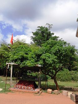
| image_caption = Dargah at Sathyagala |
|||
|skyline = |
|||
| pushpin_map = |
|||
|skyline_caption = |
|||
| pushpin_label_position = right |
|||
|latd = 12.15 |latm = |lats = |
|||
| pushpin_map_alt = |
|||
|longd= 77.10 |longm= |longs= |
|||
| pushpin_map_caption = Location in Karnataka, India |
|||
|locator_position = right |
|||
| coordinates = {{coord|12.15|N|77.10|E|display=inline,title}} |
|||
|area_total = |
|||
| subdivision_type = Country |
|||
|area_magnitude = |
|||
| subdivision_name = {{flag|India}} |
|||
|altitude = |
|||
| subdivision_type1 = [[States and territories of India|State]] |
|||
|population_total = 12503 |
|||
| subdivision_name1 = [[Karnataka]] |
|||
|population_as_of = 2001 |
|||
| subdivision_type2 = [[List of districts of India|District]] |
|||
|population_density = |
|||
| subdivision_name2 = [[Chamarajanagar]] |
|||
|sex_ratio = |
|||
| established_title = <!-- Established --> |
|||
|literacy = |
|||
| established_date = |
|||
|area_telephone = |
|||
| founder = |
|||
|postal_code = |
|||
| named_for = |
|||
|vehicle_code_range = |
|||
| parts_type = [[Taluka]]s |
|||
|climate= |
|||
| parts = Kollegal |
|||
|website= |
|||
| government_type = |
|||
| governing_body = |
|||
| unit_pref = Metric |
|||
| area_footnotes = |
|||
| area_rank = |
|||
| area_total_km2 = |
|||
| elevation_footnotes = |
|||
| elevation_m = |
|||
| population_total = 12503 |
|||
| population_as_of = 2001 |
|||
| population_rank = |
|||
| population_density_km2 = auto |
|||
| population_demonym = |
|||
| population_footnotes = |
|||
| demographics_type1 = Languages |
|||
| demographics1_title1 = Official |
|||
| demographics1_info1 = [[Kannada]] |
|||
| timezone1 = [[Indian Standard Time|IST]] |
|||
| utc_offset1 = +5:30 |
|||
| postal_code_type = <!-- [[Postal Index Number|PIN]] --> |
|||
| postal_code = |
|||
| registration_plate = |
|||
| website ={{URL|http://www.sathyagalamtemple.info/location.htm}} |
|||
| footnotes = |
|||
| official_name = |
|||
}} |
}} |
||
''' Sathegala ''' is a village in the southern state of [[Karnataka]], India.<ref name="censusindia">Village code= 2926900 {{cite web|url=http://www.censusindia.gov.in/Census_Data_2001/Village_Directory/Population_data/Population_5000_and_Above.aspx|title=Census of India : Villages with population 5000 & above|publisher=Registrar General & Census Commissioner, India|accessdate=2008-12-18}}</ref><ref name="yahoomaps">{{cite web|url=http://in.maps.yahoo.com|title=Yahoomaps India :|accessdate=2008-12-18}} Sathegala, Chamarajanagar, Karnataka</ref> It is located in the [[Kollegal]] [[taluk]] of [[Chamarajanagar district]]. |
|||
''' Sathegala ''' is a [[village]] in the southern state of [[Karnataka]], [[India]].<ref name="censusindia">Village code= 2926900 {{cite web|url=http://www.censusindia.gov.in/Census_Data_2001/Village_Directory/Population_data/Population_5000_and_Above.aspx|title=Census of India : Villages with population 5000 & above|first=Registrar General & Census Commissioner, India|accessdate=2008-12-18}}</ref><ref name="yahoomaps">{{cite web|url=http://in.maps.yahoo.com|title=Yahoomaps India :|accessdate=2008-12-18}} Sathegala, Chamarajanagar, Karnataka </ref> It is located in the [[Kollegal]] [[taluk]] of [[Chamarajanagar district]] in Karnataka. |
|||
==Demographics== |
==Demographics== |
||
As of |
{{As of|2011}} India [[census]], Sathegala had a population of 13074, with 6685 males and 6389 females.<ref name="censusindia" /> |
||
==Places of interest== |
|||
Sathyagala attained fame due to the stay of the SriVaishnavite Guru [[Vedanta Desika|Vedanta Desikan]] in the 14th century, when he had to save rare manuscripts like the Sruti-prakasha, a commentary on the Sri Bhashya of [[Ramanuja]] from the Muslim invaders to Srirangam in 1327. |
|||
There is a temple for Sri Varadharaja Swamy known as Kote Varadharaja Perumal. |
|||
Another famous and ancient temple is the Madhyarangam which has Sri Renganatha Swamy as the main Deity. |
|||
Within one furlong of the handpost junction, there are two dargah on the road to Shivanasamudram waterfalls. The first one has a decorated in the open courtyard with three surrounding building and space for devotees to take rest and have food. |
|||
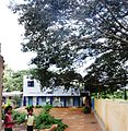
The second Dargah is set in a sylvan surroundings some two furlongs from the junction on the opposite side of the street. On the right hand side of the village school, there is a tree worship temple with a big and ancient tree besides it. |
|||
[[File:Bharachukki.JPG|thumb|Shivanasamudram Waterfalls]] |
|||
==Nearby attractions== |
|||
The [[Sivanasamudram]] Falls is on the [[Kaveri River]] after the river has wound its way through the rocks and [[ravine]]s of the [[Deccan Plateau]] and drops off to form waterfalls.<ref>{{cite web |url= http://www.bengaloorutourism.com/shivanasamudra-falls.php|title=Shivanasamudra Falls |author= |date= |work= |publisher= |accessdate=}}</ref> |
|||
==Schools== |
|||
* Sathyagala School, Handpost junction. |
|||
* Government primary school, Agrahara. |
|||
* Government High school, Sathyagala. |
|||
==See also== |
==See also== |
||
* [[Chamarajanagar]] |
* [[Chamarajanagar]] |
||
* [[Districts of Karnataka]] |
* [[Districts of Karnataka]] |
||
==Image Gallery== |
|||
<gallery> |
|||
File:School at Sathyagala.jpg|Sathyagala School |
|||
File:Sathyagala. Gool rashan zameer.jpg|Dargah Gool rashan zameer |
|||
File:Dargah on Shivanasamudra road.jpg|Dargah near school |
|||
File:Tree worship at Sathyakala Handpost.jpg|Temple near school |
|||
File:Madhya Ranga gopuram.jpg|The ancient and famous Madhya Rangam Temple |
|||
File:Swamy Desikan.jpg|A picture of Swami Vedanta Desikan. He came to Sathyagala during the Muslim Raid in 1327 and stayed here for 12 years. |
|||
</gallery> |
|||
==References== |
==References== |
||
| Line 43: | Line 98: | ||
==External links== |
==External links== |
||
* http://Chamarajanagar.nic.in/ |
* http://Chamarajanagar.nic.in/{{dead link|date=May 2018 |bot=InternetArchiveBot |fix-attempted=yes }} |
||
*http://srivaishnavam.com/desika_life_history.htm |
|||
{{Settlements in Chamarajanagar district}} |
{{Settlements in Chamarajanagar district}} |
||
[[Category:Villages in Chamarajanagar district]] |
[[Category:Villages in Chamarajanagar district]] |
||
{{Chamarajanagar-geo-stub}} |
{{Chamarajanagar-geo-stub}} |
||
Latest revision as of 11:04, 20 May 2024
Sathyagala | |
|---|---|
Village | |
 Dargah at Sathyagala | |
 | |
| Coordinates: 12°09′N 77°06′E / 12.15°N 77.10°E | |
| Country | |
| State | Karnataka |
| District | Chamarajanagar |
| Talukas | Kollegal |
| Population (2001) | |
• Total | 12,503 |
| Languages | |
| • Official | Kannada |
| Time zone | UTC+5:30 (IST) |
| Website | www |
Sathegala is a village in the southern state of Karnataka, India.[1][2] It is located in the Kollegal taluk of Chamarajanagar district.
Demographics
[edit]As of 2011[update] India census, Sathegala had a population of 13074, with 6685 males and 6389 females.[1]
Places of interest
[edit]Sathyagala attained fame due to the stay of the SriVaishnavite Guru Vedanta Desikan in the 14th century, when he had to save rare manuscripts like the Sruti-prakasha, a commentary on the Sri Bhashya of Ramanuja from the Muslim invaders to Srirangam in 1327.
There is a temple for Sri Varadharaja Swamy known as Kote Varadharaja Perumal.
Another famous and ancient temple is the Madhyarangam which has Sri Renganatha Swamy as the main Deity.
Within one furlong of the handpost junction, there are two dargah on the road to Shivanasamudram waterfalls. The first one has a decorated in the open courtyard with three surrounding building and space for devotees to take rest and have food.
The second Dargah is set in a sylvan surroundings some two furlongs from the junction on the opposite side of the street. On the right hand side of the village school, there is a tree worship temple with a big and ancient tree besides it.

Nearby attractions
[edit]The Sivanasamudram Falls is on the Kaveri River after the river has wound its way through the rocks and ravines of the Deccan Plateau and drops off to form waterfalls.[3]
Schools
[edit]- Sathyagala School, Handpost junction.
- Government primary school, Agrahara.
- Government High school, Sathyagala.
See also
[edit]Image Gallery
[edit]-
Sathyagala School
-
Dargah Gool rashan zameer
-
Dargah near school
-
Temple near school
-
The ancient and famous Madhya Rangam Temple
-
A picture of Swami Vedanta Desikan. He came to Sathyagala during the Muslim Raid in 1327 and stayed here for 12 years.
References
[edit]- ^ a b Village code= 2926900 "Census of India : Villages with population 5000 & above". Registrar General & Census Commissioner, India. Retrieved 18 December 2008.
- ^ "Yahoomaps India :". Retrieved 18 December 2008. Sathegala, Chamarajanagar, Karnataka
- ^ "Shivanasamudra Falls".
External links
[edit]


