Caxito: Difference between revisions
Appearance
Content deleted Content added
GrouchoBot (talk | contribs) m robot Adding: hr:Caxito |
m Sort Template:Expand language by topic |
||
| (41 intermediate revisions by 28 users not shown) | |||
| Line 1: | Line 1: | ||
{{expand Portuguese|topic=geo|date=June 2022}} |
|||
{{Infobox settlement |
{{Infobox settlement |
||
<!--See the Table at Infobox Settlement for all fields and descriptions of usage--> |
<!--See the Table at Infobox Settlement for all fields and descriptions of usage--> |
||
| Line 6: | Line 8: | ||
|native_name = <!-- for cities whose native name is not in English --> |
|native_name = <!-- for cities whose native name is not in English --> |
||
|nickname = |
|nickname = |
||
|settlement_type = [[Communes of Angola|Commune]] and town |
|settlement_type = [[Communes of Angola|Commune]] and [[List of cities and towns in Angola|town]] |
||
|motto = |
|motto = |
||
<!-- images and maps -----------> |
<!-- images and maps -----------> |
||
|image_skyline = |
|image_skyline = Igreja Caxito.JPG |
||
|imagesize = |
|imagesize = |
||
|image_caption = |
|image_caption = |
||
| Line 23: | Line 25: | ||
|pushpin_map = Angola<!-- the name of a location map as per http://en.wikipedia.org/wiki/Template:Location_map --> |
|pushpin_map = Angola<!-- the name of a location map as per http://en.wikipedia.org/wiki/Template:Location_map --> |
||
|pushpin_label_position =right |
|pushpin_label_position =right |
||
|pushpin_mapsize = |
|pushpin_mapsize =200 |
||
|pushpin_map_caption =Location in Angola |
|pushpin_map_caption =Location in Angola |
||
<!-- Location ------------------> |
<!-- Location ------------------> |
||
|coordinates_region = AO |
|||
|subdivision_type = Country |
|subdivision_type = Country |
||
|subdivision_name = {{flag|Angola}} |
|subdivision_name = {{flag|Angola}} |
||
|subdivision_type1 = [[Provinces of Angola|Province]] |
|subdivision_type1 = [[Provinces of Angola|Province]] |
||
|subdivision_name1 = [[Bengo Province]] |
|subdivision_name1 = [[Bengo Province|Bengo]] |
||
|subdivision_type2 =[[Municipalities of Angola|Municipality]] |
|subdivision_type2 = [[Municipalities of Angola|Municipality]] |
||
|subdivision_name2 = |
|subdivision_name2 = [[Dande]] |
||
|subdivision_type3 = |
|subdivision_type3 = |
||
|subdivision_name3 = |
|subdivision_name3 = |
||
| Line 46: | Line 47: | ||
<!-- Area ---------------------> |
<!-- Area ---------------------> |
||
|area_magnitude = |
|area_magnitude = |
||
|unit_pref =Imperial <!--Enter: Imperial, if Imperial (metric) is desired--> |
|||
|area_footnotes = |
|area_footnotes = |
||
|area_total_km2 = |
|area_total_km2 = 167 |
||
|area_land_km2 = <!--See table @ Template:Infobox Settlement for details on automatic unit conversion--> |
|area_land_km2 = <!--See table @ Template:Infobox Settlement for details on automatic unit conversion--> |
||
<!-- Population -----------------------> |
<!-- Population -----------------------> |
||
|population_as_of = |
|population_as_of = 2014 |
||
|population_footnotes =<ref>[https://www.citypopulation.de/en/angola/communes/admin/ Citypopulation.de] Population of provinces and communes in Angola</ref> |
|||
|population_footnotes = |
|||
|population_note = |
|population_note = |
||
|population_total = |
|population_total = 77276 |
||
|population_density_km2 = |
|population_density_km2 = auto |
||
|population_density_sq_mi = |
|population_density_sq_mi = |
||
|population_metro = |
|population_metro = |
||
| Line 69: | Line 69: | ||
|timezone_DST = |
|timezone_DST = |
||
|utc_offset_DST = |
|utc_offset_DST = |
||
|coordinates = {{coord|8|34|48|S|13|39|51|E|region:AO|display=inline}} |
|||
|latd=8|latm=34 |lats=48 |latNS=S |
|||
|longd=13|longm=39|longs=51|longEW=E |
|||
|elevation_footnotes = <!--for references: use <ref> </ref> tags--> |
|elevation_footnotes = <!--for references: use <ref> </ref> tags--> |
||
|elevation_m = |
|elevation_m = 84 |
||
|elevation_ft = |
|elevation_ft = |
||
<!-- Area/postal codes & others --------> |
<!-- Area/postal codes & others --------> |
||
| Line 78: | Line 77: | ||
|postal_code = |
|postal_code = |
||
|area_code = |
|area_code = |
||
|blank_name = |
|blank_name = [[Köppen climate classification|Climate]] |
||
|blank_info = |
|blank_info = [[Semi-arid climate#Hot semi-arid climates|BSh]] |
||
|blank1_name = |
|blank1_name = |
||
|blank1_info = |
|blank1_info = |
||
|website = |
|website = |
||
|footnotes = |
|footnotes = |
||
}} |
}} |
||
'''Caxito ''' is a |
'''Caxito ''' is a town, with a population of 55,000 (2014),<ref>[https://www.citypopulation.de/en/angola/cities/ Citypopulation.de] Population of cities & urban localities in Angola</ref> and a [[Communes of Angola|commune]] in the municipality of [[Dande]], province of [[Bengo Province|Bengo]], Angola. It is also the capital of the province.<ref>{{Cite web|url=http://www.info-angola.ao/index.php?option=com_content&task=view&id=72&Itemid=66|title=Info Angola|website=www.info-angola.ao|language=pt-pt|access-date=2017-07-05}}</ref> |
||
==Transportation== |
|||
The northern line of [[Angolan Railways]] passes through. |
The northern line of [[Luanda Railway|Angolan Railways]] passes through the town. |
||
[[File:Instalações da ex-Açucareira do Caxito 5 - panoramio.jpg|thumb|left|A panel of [[azulejo]]s in Caxito]] |
|||
{{clear left}} |
|||
==References== |
==References== |
||
<references/> |
|||
{{Reflist}} |
|||
{{coord|08|34|48|S|13|39|51|E|region:AO_type:city|display=title}} |
{{coord|08|34|48|S|13|39|51|E|region:AO_type:city|display=title}} |
||
| ⚫ | |||
[[Category:Populated places in Bengo Province]] |
[[Category:Populated places in Bengo Province]] |
||
[[Category:Communes |
[[Category:Communes in Bengo Province]] |
||
[[Category:Provincial capitals in Angola]] |
[[Category:Provincial capitals in Angola]] |
||
{{Angola-geo-stub}} |
{{Angola-geo-stub}} |
||
| ⚫ | |||
[[af:Caxito]] |
|||
[[es:Caxito]] |
|||
[[fr:Caxito]] |
|||
[[hr:Caxito]] |
|||
[[it:Caxito]] |
|||
[[lt:Kašitas]] |
|||
[[nl:Caxito]] |
|||
[[pl:Caxito]] |
|||
[[pt:Caxito]] |
|||
[[ro:Caxito]] |
|||
[[war:Caxito]] |
|||
Latest revision as of 01:01, 28 May 2024
You can help expand this article with text translated from the corresponding article in Portuguese. (June 2022) Click [show] for important translation instructions.
|
Caxito | |
|---|---|
 | |
| Coordinates: 8°34′48″S 13°39′51″E / 8.58000°S 13.66417°E | |
| Country | |
| Province | Bengo |
| Municipality | Dande |
| Area | |
• Total | 167 km2 (64 sq mi) |
| Elevation | 84 m (276 ft) |
| Population (2014)[1] | |
• Total | 77,276 |
| • Density | 460/km2 (1,200/sq mi) |
| Time zone | UTC+1 (WAT) |
| Climate | BSh |
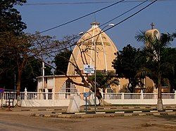
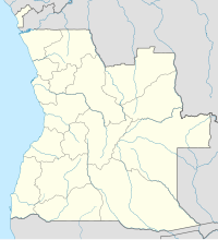
Caxito is a town, with a population of 55,000 (2014),[2] and a commune in the municipality of Dande, province of Bengo, Angola. It is also the capital of the province.[3]
Transportation
[edit]The northern line of Angolan Railways passes through the town.

References
[edit]- ^ Citypopulation.de Population of provinces and communes in Angola
- ^ Citypopulation.de Population of cities & urban localities in Angola
- ^ "Info Angola". www.info-angola.ao (in European Portuguese). Retrieved 2017-07-05.
08°34′48″S 13°39′51″E / 8.58000°S 13.66417°E

