Maliana: Difference between revisions
No edit summary |
m Disambiguating links to Tetum (link changed to Tetum language) using DisamAssist. |
||
| (46 intermediate revisions by 34 users not shown) | |||
| Line 1: | Line 1: | ||
{{ |
{{Expand German|topic=geo|date=November 2010|Maliana}} |
||
{{More citations needed|date=February 2017}} |
|||
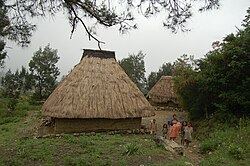
[[image:Maliana.jpg|thumb|Village in the sub-district of Maliana]] |
|||
{{EngvarB|date=September 2022}} |
|||
{{Use dmy dates|date=September 2022}} |
|||
{{About|the city|the [[Administrative posts of East Timor|administrative post]]|Maliana Administrative Post}} |
|||
{{Infobox settlement |
|||
<!--See the Table at Infobox Settlement for all fields and descriptions of usage--> |
|||
<!-- Basic info ----------------> |
|||
|official_name = Maliana |
|||
|other_name = |
|||
|native_name = <!-- for cities whose native name is not in English --> |
|||
|nickname = |
|||
|settlement_type = City |
|||
|motto = |
|||
<!-- images and maps -----------> |
|||
|image_skyline = Maliana.jpg |
|||
|imagesize = |
|||
|image_caption = Village in the administrative post of Maliana |
|||
|image_flag = |
|||
|flag_size = |
|||
|image_seal = |
|||
|seal_size = |
|||
|image_shield = |
|||
|shield_size = |
|||
|image_blank_emblem = |
|||
|blank_emblem_type = |
|||
|blank_emblem_size = |
|||
|image_map = Maliana posto administrativo.png |
|||
|mapsize = 250px |
|||
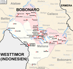
|map_caption = Administrative post and city of Maliana |
|||
|image_map1 = |
|||
|mapsize1 = |
|||
|map_caption1 = |
|||
|image_dot_map = |
|||
|dot_mapsize = |
|||
|dot_map_caption = |
|||
|dot_x = |dot_y = |
|||
|pushpin_map = East Timor<!-- the name of a location map as per http://en.wikipedia.org/wiki/Template:Location_map --> |
|||
|pushpin_label_position =bottom |
|||
|pushpin_map_caption =Location in East Timor |
|||
<!-- Location ------------------> |
|||
|subdivision_type = Country |
|||
|subdivision_name = {{Flag|East Timor}} |
|||
|subdivision_type1 = [[Municipalities of East Timor|Municipality]] |
|||
|subdivision_name1 = [[Bobonaro District|Bobonaro]] |
|||
|subdivision_type2 = {{nowrap|[[Administrative posts of East Timor|Administrative post]]}} |
|||
|subdivision_name2 = [[Maliana Administrative Post|Maliana]] |
|||
|subdivision_type3 = |
|||
|subdivision_name3 = |
|||
|subdivision_type4 = |
|||
|subdivision_name4 = |
|||
<!-- Politics -----------------> |
|||
|government_footnotes = |
|||
|government_type = |
|||
|leader_title =Mayor |
|||
|leader_name = |
|||
|leader_title1 = <!-- for places with, say, both a mayor and a city manager --> |
|||
|leader_name1 = |
|||
|leader_title2 = |
|||
|leader_name2 = |
|||
|leader_title3 = |
|||
|leader_name3 = |
|||
|leader_title4 = |
|||
|leader_name4 = |
|||
|established_title = <!-- Settled --> |
|||
|established_date = |
|||
|established_title2 = <!-- Incorporated (town) --> |
|||
|established_date2 = |
|||
|established_title3 = <!-- Incorporated (city) --> |
|||
|established_date3 = |
|||
<!-- Area ---------------------> |
|||
|area_magnitude = |
|||
|area_footnotes = |
|||
|area_total_km2 = 239.35 |
|||
|area_land_km2 = <!--See table @ Template:Infobox Settlement for details on automatic unit conversion--> |
|||
|area_water_km2 = |
|||
|area_total_sq_mi = |
|||
|area_land_sq_mi = |
|||
|area_water_sq_mi = |
|||
|area_water_percent = |
|||
|area_urban_km2 = |
|||
|area_urban_sq_mi = |
|||
|area_metro_km2 = |
|||
|area_metro_sq_mi = |
|||
|area_blank1_title = |
|||
|area_blank1_km2 = |
|||
|area_blank1_sq_mi = |
|||
<!-- Population -----------------------> |
|||
|population_as_of = 2015 census |
|||
|population_footnotes = |
|||
|population_note = |
|||
|population_total = 12220 |
|||
|population_density_km2 = auto |
|||
|population_density_sq_mi = |
|||
|population_metro = |
|||
|population_density_metro_km2 = |
|||
|population_density_metro_sq_mi = |
|||
|population_urban = |
|||
|population_density_urban_km2 = |
|||
|population_density_urban_sq_mi = |
|||
|population_blank1_title =Ethnicities |
|||
|population_blank1 = |
|||
|population_blank2_title =Religions |
|||
|population_blank2 = |
|||
|population_density_blank1_km2 = |
|||
|population_density_blank1_sq_mi = |
|||
<!-- General information ---------------> |
|||
| timezone = {{TL wikidata|timezone}} |
|||
| utc_offset = {{TL wikidata|utc_offset}} |
|||
|coordinates = {{coord|8|59|30|S|125|13|11|E|region:TL|display=inline}} |
|||
|elevation_footnotes = <!--for references: use <ref> </ref> tags--> |
|||
|elevation_m = 402 |
|||
|elevation_ft = |
|||
<!-- Area/postal codes & others --------> |
|||
|postal_code_type = <!-- enter ZIP code, Postcode, Post code, Postal code... --> |
|||
|postal_code = |
|||
|area_code = |
|||
|blank_name = [[Köppen climate classification|Climate]] |
|||
|blank_info = [[Tropical savanna climate|Aw]] |
|||
|blank1_name = |
|||
|blank1_info = |
|||
|website = |
|||
|footnotes = |
|||
}} |
|||
'''Maliana''' is a city in [[East Timor]], 149 |
'''Maliana''' is a city in [[East Timor]],<ref>{{cite web|url=http://www.fides.org/it/news/61757-ASIA_TIMOR_EST_I_cattolici_impegnati_in_ecumenismo_e_istruzione#.WK1EtW-GOM8 |title=Asia/Timor Est - I cattolici impegnati in ecumenismo e istruzione |author=Agenzia Fides |publisher=Argenzia Fides |date=18 February 2017 |accessdate=2017-02-22}}</ref> 149 kilometers southwest of [[Dili]], the national capital. It has a population of 22,000. It is the capital of the [[Districts of East Timor|district]] of [[Bobonaro District|Bobonaro]] and [[Maliana Subdistrict]], and is located just a few kilometers from the border with [[Indonesia]]. It is also the see city of the [[Roman Catholic Diocese of Maliana]], which was formed by [[Pope Benedict XVI]] with territory taken from the [[Roman Catholic Diocese of Dili]]. |
||
Maliana |
Maliana an important [[agriculture]] sector, especially rice production. The majority of Maliana's population is heavily dependent on agriculture for their livelihoods, this is because rice became the preferred staple food among many Timorese. Most of the population are farmers cultivating rice and [[maize]]. During Indonesian occupation, Maliana became a rice barn town to support other districts in East Timor, and export to other places in [[Western Timor]] of [[Indonesia]]. |
||
Maliana has seven villages consisting of Lahomea, Holsa, Ritabou, Odomau, Raifun, Tapo-Memo and Saburai. There are two main sources of water irrigation that supply water to [[paddy field]]s such Bulobu River, Nunura River, Malibaka and Bui Pira river. [[Bunak]] and [[Kemak language|Kemak]] are the native dialects of Maliana but most people understand and speak [[Tetum language|Tetum]]. |
|||
During Indonesian occupation Maliana became an area of rice production storage to support other districts in East Timor, and export to other places in [[Atambua]] [[Western Timor]]. |
|||
Maliana has five sub-[[district]]s consisting of Lahomea, Holsa, Ritabou, Odomau and Kor-luli. There are two main sources of water irrigation that supply water to [[paddy field]]s such Nunura River, Soso and Bui Pira river. The dialects that most people use are [[Bunak]] and [[Kemak]] but most people understand the [[Tetum]] language. |
|||
Maliana had one of the preferred schools during Portuguese occupation, known as Collegio [[Infante sagres]]. This was under a catholic mission and many East Timor educated people have graduated from this senior high School. |
Maliana had one of the preferred schools during Portuguese occupation, known as Collegio [[Infante sagres]]. This was under a catholic mission and many East Timor educated people have graduated from this senior high School. |
||
The citizens of Maliana were instrumental to the Australian army between 1999 and 2001, during the [[United Nations Transitional Administration in East Timor|UNTAET]] operation. Employed as "Locally Employed Civilians" by a small contingent from the 110th Signals Squadron, the people of Maliana provided domestic support, as well as local intelligence regarding the threat of Indonesian militia to the soldiers and civilian contractors working in the area. |
|||
{{East Timor capitals}} |
|||
Australian newsman Greg Shackleton and his colleagues (the "[[Balibo Five]]") filed news reports from Maliana (then in [[Portuguese Timor]]) shortly before their fateful trip to Balibo in October, 1975.<ref>{{cite web|url=http://www.abc.net.au/pm/content/2007/s1917773.htm |title=Whitlam appears at Balibo Inquiry |author=Emma Alberici |publisher=ABC Australia |date=8 May 2007 |accessdate=2017-02-22}}</ref> |
|||
{{Coord|8|59|S|125|13|E|region:TL_type:city|display=title}} |
|||
== Sister cities == |
|||
[[Category:Cities, towns and villages in East Timor]] |
|||
[[City of Knox]], [[Australia]] |
|||
[[Municipality of Leichhardt]], Australia |
|||
== References == |
|||
{{EastTimor-geo-stub}} |
|||
{{Reflist}} |
|||
== External links == |
|||
{{commons category}} |
|||
*{{wikivoyage-inline|Maliana}} |
|||
{{Portal bar|Asia|Geography}}{{EastTimor-geo-stub}}{{East Timor capitals}} |
|||
{{Coord|8|59|S|125|13|E|region:TL_type:city|display=title}} |
|||
[[ |
[[Category:Maliana| ]] |
||
[[Category:Populated places in East Timor]] |
|||
[[es:Maliana]] |
|||
[[Category:Bobonaro Municipality]] |
|||
[[id:Maliana]] |
|||
[[ms:Maliana]] |
|||
[[nl:Maliana]] |
|||
[[pl:Maliana]] |
|||
[[pt:Maliana]] |
|||
Revision as of 19:36, 1 June 2024
You can help expand this article with text translated from the corresponding article in German. (November 2010) Click [show] for important translation instructions.
|
This article needs additional citations for verification. (February 2017) |
Maliana | |
|---|---|
City | |
 Village in the administrative post of Maliana | |
 Administrative post and city of Maliana | |
| Coordinates: 8°59′30″S 125°13′11″E / 8.99167°S 125.21972°E | |
| Country | |
| Municipality | Bobonaro |
| Administrative post | Maliana |
| Area | |
• Total | 239.35 km2 (92.41 sq mi) |
| Elevation | 402 m (1,319 ft) |
| Population (2015 census) | |
• Total | 12,220 |
| • Density | 51/km2 (130/sq mi) |
| Time zone | UTC+09:00 (TLT) |
| Climate | Aw |
Maliana is a city in East Timor,[1] 149 kilometers southwest of Dili, the national capital. It has a population of 22,000. It is the capital of the district of Bobonaro and Maliana Subdistrict, and is located just a few kilometers from the border with Indonesia. It is also the see city of the Roman Catholic Diocese of Maliana, which was formed by Pope Benedict XVI with territory taken from the Roman Catholic Diocese of Dili.
Maliana an important agriculture sector, especially rice production. The majority of Maliana's population is heavily dependent on agriculture for their livelihoods, this is because rice became the preferred staple food among many Timorese. Most of the population are farmers cultivating rice and maize. During Indonesian occupation, Maliana became a rice barn town to support other districts in East Timor, and export to other places in Western Timor of Indonesia.
Maliana has seven villages consisting of Lahomea, Holsa, Ritabou, Odomau, Raifun, Tapo-Memo and Saburai. There are two main sources of water irrigation that supply water to paddy fields such Bulobu River, Nunura River, Malibaka and Bui Pira river. Bunak and Kemak are the native dialects of Maliana but most people understand and speak Tetum. Maliana had one of the preferred schools during Portuguese occupation, known as Collegio Infante sagres. This was under a catholic mission and many East Timor educated people have graduated from this senior high School.
The citizens of Maliana were instrumental to the Australian army between 1999 and 2001, during the UNTAET operation. Employed as "Locally Employed Civilians" by a small contingent from the 110th Signals Squadron, the people of Maliana provided domestic support, as well as local intelligence regarding the threat of Indonesian militia to the soldiers and civilian contractors working in the area.
Australian newsman Greg Shackleton and his colleagues (the "Balibo Five") filed news reports from Maliana (then in Portuguese Timor) shortly before their fateful trip to Balibo in October, 1975.[2]
Sister cities
Municipality of Leichhardt, Australia
References
- ^ Agenzia Fides (18 February 2017). "Asia/Timor Est - I cattolici impegnati in ecumenismo e istruzione". Argenzia Fides. Retrieved 22 February 2017.
- ^ Emma Alberici (8 May 2007). "Whitlam appears at Balibo Inquiry". ABC Australia. Retrieved 22 February 2017.
External links
 Maliana travel guide from Wikivoyage

