Sadki, Kuyavian-Pomeranian Voivodeship: Difference between revisions
m →History: clean up, replaced: Warszawa → Warsaw (2), Instytut Historii Polskiej Akademii Nauk → Institute of History, Polish Academy of Sciences |
m →top: Format administrative division links, remove DEFAULTSORTKEY as per WP:SORTKEY, remove One Source for stubs, minor formatting changes (AWB) |
||
| (2 intermediate revisions by one other user not shown) | |||
| Line 5: | Line 5: | ||
| image_skyline = Sadki church.jpg |
| image_skyline = Sadki church.jpg |
||
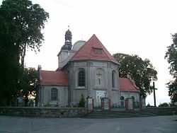
| image_caption = Church of Saint Adalbert |
| image_caption = Church of Saint Adalbert |
||
| image_shield = |
| image_shield = |
||
| subdivision_type = [[ |
| subdivision_type = [[List of sovereign states|Country]] |
||
| subdivision_name = {{POL}} |
| subdivision_name = {{POL}} |
||
| subdivision_type1 = [[Voivodeships of Poland|Voivodeship]] |
| subdivision_type1 = [[Voivodeships of Poland|Voivodeship]] |
||
| Line 14: | Line 14: | ||
| subdivision_type3 = [[Gmina]] |
| subdivision_type3 = [[Gmina]] |
||
| subdivision_name3 = [[Gmina Sadki|Sadki]] |
| subdivision_name3 = [[Gmina Sadki|Sadki]] |
||
| coordinates = {{coord|53|9|41|N|17|26|46|E|region:PL|display= |
| coordinates = {{coord|53|9|41|N|17|26|46|E|region:PL|display=title,inline}} |
||
| pushpin_map = Poland |
| pushpin_map = Poland |
||
| timezone = [[Central European Time|CET]] |
| timezone = [[Central European Time|CET]] |
||
| utc_offset = +1 |
| utc_offset = +1 |
||
| Line 26: | Line 26: | ||
| blank_name_sec2 = [[National roads in Poland|National roads]] |
| blank_name_sec2 = [[National roads in Poland|National roads]] |
||
| blank_info_sec2 = [[File:DK10-PL.svg|32px]] |
| blank_info_sec2 = [[File:DK10-PL.svg|32px]] |
||
| website = http://www.sadki.pl |
| website = http://www.sadki.pl |
||
}} |
|||
'''Sadki''' {{IPAc-pl|'|s|a|t|k|i}} is a village in [[Nakło County]], [[Kuyavian-Pomeranian Voivodeship]], in north-central Poland.<ref name="TERYT">{{cite web|url=http://www.stat.gov.pl/broker/access/prefile/listPreFiles.jspa|title=Central Statistical Office (GUS) - TERYT (National Register of Territorial Land Apportionment Journal)|date=2008-06-01|language=Polish}}</ref> It is the seat of the [[gmina]] (administrative district) called [[Gmina Sadki]]. It lies approximately {{convert|11|km|mi|0}} west of [[Nakło nad Notecią]] and {{convert|38|km|mi|0|abbr=on}} west of [[Bydgoszcz]]. |
'''Sadki''' {{IPAc-pl|'|s|a|t|k|i}} is a village in [[Nakło County]], [[Kuyavian-Pomeranian Voivodeship]], in north-central Poland.<ref name="TERYT">{{cite web|url=http://www.stat.gov.pl/broker/access/prefile/listPreFiles.jspa|title=Central Statistical Office (GUS) - TERYT (National Register of Territorial Land Apportionment Journal)|date=2008-06-01|language=Polish}}</ref> It is the seat of the [[gmina]] (administrative district) called [[Gmina Sadki]]. It lies approximately {{convert|11|km|mi|0}} west of [[Nakło nad Notecią]] and {{convert|38|km|mi|0|abbr=on}} west of [[Bydgoszcz]]. |
||
| Line 48: | Line 48: | ||
[[Category:Villages in Nakło County]] |
[[Category:Villages in Nakło County]] |
||
[[Category: |
[[Category:Sites of World War II massacres of Poles]] |
||
[[Category: |
[[Category:Intelligenzaktion massacre locations]] |
||
Latest revision as of 07:26, 14 June 2024
Sadki | |
|---|---|
Village | |
 Church of Saint Adalbert | |
| Coordinates: 53°9′41″N 17°26′46″E / 53.16139°N 17.44611°E | |
| Country | |
| Voivodeship | Kuyavian-Pomeranian |
| County | Nakło |
| Gmina | Sadki |
| Elevation | 90 m (300 ft) |
| Population (approx.) | |
• Total | 2,000 |
| Time zone | UTC+1 (CET) |
| • Summer (DST) | UTC+2 (CEST) |
| Vehicle registration | CNA |
| National roads | |
| Website | http://www.sadki.pl |
Sadki [ˈsatki] is a village in Nakło County, Kuyavian-Pomeranian Voivodeship, in north-central Poland.[1] It is the seat of the gmina (administrative district) called Gmina Sadki. It lies approximately 11 kilometres (7 mi) west of Nakło nad Notecią and 38 km (24 mi) west of Bydgoszcz.
History
[edit]The area formed part of Poland since the establishment of the state in the 10th century. Sadki was a royal village, administratively located in the Nakło County in the Kalisz Voivodeship in the Greater Poland Province of the Kingdom of Poland.[2] The village was annexed by Prussia in the late-18th-century Partitions of Poland, and was also part of Germany from 1871. Following World War I, Poland regained independence and control of the village.
During the German occupation of Poland (World War II), the local forest was the site of executions of 86 Poles from Sadki and other nearby villages, perpetrated by the SS and Selbstschutz in October and November 1939 as part of the Intelligenzaktion.[3]
Sports
[edit]The local football club is GLZS Sadki.[4] It competes in the lower leagues.
Notable people
[edit]- Rev. Henryk Malak (1912–1987), Polish Roman Catholic priest arrested by the Nazis and incarcerated in Nazi concentration camps during World War II
References
[edit]- ^ "Central Statistical Office (GUS) - TERYT (National Register of Territorial Land Apportionment Journal)" (in Polish). 2008-06-01.
- ^ Atlas historyczny Polski. Wielkopolska w drugiej połowie XVI wieku. Część I. Mapy, plany (in Polish). Warsaw: Institute of History, Polish Academy of Sciences. 2017. p. 1b.
- ^ Wardzyńska, Maria (2009). Był rok 1939. Operacja niemieckiej policji bezpieczeństwa w Polsce. Intelligenzaktion (in Polish). Warsaw: IPN. p. 164.
- ^ "GLZS Sadki - strona klubu" (in Polish). Retrieved 6 February 2022.


