Tapi district: Difference between revisions
Snehrashmi (talk | contribs) →Politics: updated to 15th Gujarat Assembly |
mNo edit summary Tags: Visual edit Mobile edit Mobile web edit |
||
| (15 intermediate revisions by 7 users not shown) | |||
| Line 1: | Line 1: | ||
{{Use dmy dates|date=July 2019}} |
{{Use dmy dates|date=July 2019}} |
||
{{more citations needed|date=January 2016}} |
|||
{{Infobox settlement |
{{Infobox settlement |
||
| name |
| name = Tapi district |
||
| native_name |
| native_name = |
||
| native_name_lang |
| native_name_lang = |
||
| other_name |
| other_name = |
||
| nickname |
| nickname = |
||
| settlement_type |
| settlement_type = [[List of districts of Gujarat|District]] of [[Gujarat]] |
||
| image_skyline |
| image_skyline = Tapi District.1311.jpg |
||
| image_alt |
| image_alt = |
||
| image_caption |
| image_caption = River in Tapi district |
||
| image_map = {{maplink|frame=yes|frame-width=300|frame-height=300|frame-align=center|type=shape|id=Q670165|stroke-colour=#C60C30|stroke-width=2|text=Interactive Map Outlining Tapi District}} |
|||
| ⚫ | |||
| map_caption |
| map_caption = |
||
| coordinates |
| coordinates = {{Wikidatacoord|Q670165|region:IN-GJ|display=inline,title}} |
||
| subdivision_type |
| subdivision_type = Country |
||
| subdivision_name |
| subdivision_name = {{flag|India}} |
||
| subdivision_type1 |
| subdivision_type1 = [[States and territories of India|State]] |
||
| subdivision_name1 |
| subdivision_name1 = [[Gujarat]] |
||
| established_title |
| established_title = <!-- Established --> |
||
| established_date |
| established_date = |
||
| founder |
| founder = |
||
| named_for |
| named_for = |
||
| seat_type |
| seat_type = Headquarters |
||
| seat |
| seat = [[Vyara]] |
||
| government_type |
| government_type = |
||
| governing_body |
| governing_body = Nagar Palika |
||
| leader_title |
| leader_title = District Collectorate |
||
| leader_name |
| leader_name = |
||
| unit_pref |
| unit_pref = Metric |
||
| area_footnotes |
| area_footnotes = |
||
| area_rank |
| area_rank = |
||
| area_total_km2 |
| area_total_km2 = 3139 |
||
| elevation_footnotes |
| elevation_footnotes = |
||
| elevation_m |
| elevation_m = |
||
| population_total |
| population_total = 807,022 |
||
| population_as_of |
| population_as_of = 2011 |
||
| population_rank |
| population_rank = |
||
| population_density_km2 |
| population_density_km2 = auto |
||
| population_demonym |
| population_demonym = |
||
| population_footnotes |
| population_footnotes = |
||
| demographics_type1 |
| demographics_type1 = Languages |
||
| demographics1_title1 |
| demographics1_title1 = Official |
||
| demographics1_info1 |
| demographics1_info1 = [[Gujarati language|Gujarati]], [[Hindi language|Hindi]] |
||
| timezone1 |
| timezone1 = [[Indian Standard Time|IST]] |
||
| utc_offset1 |
| utc_offset1 = +5:30 |
||
| postal_code_type |
| postal_code_type = <!-- [[Postal Index Number|PIN]] --> |
||
| postal_code |
| postal_code = 394650 |
||
| registration_plate |
| registration_plate = GJ 26 |
||
| area_code |
| area_code = 02624, 02625, 02626, 02628 |
||
| website |
| website = {{URL|https://tapi.nic.in/}} |
||
| footnotes |
| footnotes = |
||
| ⚫ | |||
| map_caption1 = Location of district in Gujarat |
|||
}} |
}} |
||
'''Tapi district''' is one of the 33 districts of [[Gujarat]] state in western [[India]]. It has seven [[talukas]] [[Vyara]], [[Songadh]], [[Nijhar|Nizar]], [[Valod]], [[Uchhal]], Dolavan |
'''Tapi district''' is one of the 33 districts of [[Gujarat]] state in western [[India]]. It has seven [[talukas]]: [[Vyara]], [[Songadh]], [[Nijhar|Nizar]], [[Valod]], [[Uchhal]], Dolavan and [[Kukarmunda]]. Vyara town is the district headquarters. Tapi has 523 villages and two municipalities. The district was formed in 2007 out of some talukas that were separated from [[Surat district]].<ref>{{cite web|url=https://tapi.gujarat.gov.in/about-tapi|title=About Tapi|publisher=Government of Gujarat}}</ref> |
||
==Demographics== |
==Demographics== |
||
| ⚫ | {{historical populations|11=1901|12=1,55,894|13=1911|14=1,66,720|15=1921|16=1,67,361|17=1931|18=1,83,989|19=1941|20=2,21,965|21=1951|22=2,63,380|23=1961|24=3,29,134|25=1971|26=4,57,502|27=1981|28=5,27,971|29=1991|30=6,26,979|31=2001|32=7,19,634|33=2011|34=8,07,022|percentages=pagr|footnote=source:<ref>[http://www.censusindia.gov.in/2011census/PCA/A2_Data_Table.html Decadal Variation In Population Since 1901]</ref>|align=right}} |
||
According to the [[2011 census of India|2011 census]], Tapi district has a [[Demographics of India|population]] of 807,022,<ref name=districtcensus>{{ |
According to the [[2011 census of India|2011 census]], Tapi district has a [[Demographics of India|population]] of 807,022,<ref name=districtcensus>{{cite web |title=District Census Hand Book – Tapi |url=https://censusindia.gov.in/nada/index.php/catalog/420/download/1328/DH_2011_2426_PART_A_DCHB_TAPI.pdf |website=[[Census of India]] |publisher=[[Registrar General and Census Commissioner of India]]}}</ref> roughly equal to the nation of [[Comoros]]<ref name="cia">{{cite web | author = US Directorate of Intelligence | title = Country Comparison:Population | url = https://www.cia.gov/library/publications/the-world-factbook/rankorder/2119rank.html | archive-url = https://web.archive.org/web/20070613004507/https://www.cia.gov/library/publications/the-world-factbook/rankorder/2119rank.html | url-status = dead | archive-date = 13 June 2007 | access-date = 2011-10-01 | quote = Comoros 794,683 July 2011 est. |
||
}}</ref> or the US state of [[South Dakota]].<ref>{{cite web|url=http://2010.census.gov/2010census/data/apportionment-pop-text.php|title=2010 Resident Population Data|publisher=U. S. Census Bureau|access-date=2011-09-30| quote =South Dakota 814,180 |
}}</ref> or the US state of [[South Dakota]].<ref>{{cite web|url=http://2010.census.gov/2010census/data/apportionment-pop-text.php|title=2010 Resident Population Data|publisher=U. S. Census Bureau|access-date=2011-09-30| quote =South Dakota 814,180 |
||
}}</ref> This gives it a ranking of 484th in India (out of a total of [[Districts of India|640]]).<ref name=districtcensus/> The district has a population density of {{convert| 234 |PD/sqkm|PD/sqmi}} .<ref name=districtcensus/> Its [[Family planning in India|population growth rate]] over the decade 2001-2011 was |
}}</ref> This gives it a ranking of 484th in India (out of a total of [[Districts of India|640]]).<ref name=districtcensus/> The district has a population density of {{convert| 234 |PD/sqkm|PD/sqmi}} .<ref name=districtcensus/> Its [[Family planning in India|population growth rate]] over the decade 2001-2011 was 12.07%.<ref name=districtcensus/> Tapi has a [[sex ratio]] of 1004 [[Women in India|females]] for every 1000 males,<ref name=districtcensus/> and a [[Literacy in India|literacy rate]] of 69.23%. 9.85% of the population lives in urban areas. Scheduled Castes and Scheduled Tribes make up 1.01% and 84.18% of the population respectively.<ref name=districtcensus/> |
||
{{bar box |
{{bar box |
||
|title=Religions in Tapi district (2011)<ref name="Religion">{{ |
|title=Religions in Tapi district (2011)<ref name="Religion">{{Cite web |date=2011 |title=Population by Religion - Gujarat |url=https://censusindia.gov.in/nada/index.php/catalog/11373/download/14486/DDW24C-01%20MDDS.XLS |website=censusindia.gov.in |publisher=[[Registrar General and Census Commissioner of India]]}}</ref> |
||
|titlebar=#Fcd116 |
|titlebar=#Fcd116 |
||
|float=left |
|float=left |
||
| Line 65: | Line 67: | ||
{{bar percent|[[Hinduism]]|darkorange|89.95}} |
{{bar percent|[[Hinduism]]|darkorange|89.95}} |
||
{{bar percent|[[Christianity in Gujarat|Christianity]]|dodgerblue|6.56}} |
{{bar percent|[[Christianity in Gujarat|Christianity]]|dodgerblue|6.56}} |
||
{{bar percent|[[Islam]]|green|2.76}} |
{{bar percent|[[Gujarati Muslims|Islam]]|green|2.76}} |
||
{{bar percent|Other or not stated|black|0.73}} |
{{bar percent|Other or not stated|black|0.73}} |
||
|caption=Distribution of religions |
|caption=Distribution of religions |
||
}} |
}} |
||
{{Pie chart |
|||
| ⚫ | At the time of the [[2011 Census of India]], 49.09% of the population in the district spoke [[Gujarati language|Gujarati]], |
||
|thumb = left |
|||
|caption = Languages of Tapi district (2011)<ref name="language"/> |
|||
|label1 = [[Gujarati language|Gujarati]] |value1 = 49.09 |color1 = skyblue |
|||
|label2 = [[Gamit language|Gamit]] |value2 = 14.53 |color2 = darkturquoise |
|||
|label3 = [[Bhili language|Bhili]] |value3 = 9.96 |color3 = teal |
|||
|label4 = [[Vasavi language|Vasavi]] |value4 = 8.02 |color4 = cadetblue |
|||
|label5 = [[Chodri language|Chodri]] |value5 = 5.96 |color5 = lightseagreen |
|||
|label6 = [[Hindi]] |value6 = 2.86 |color6 = orange |
|||
|label7 = [[Marathi language|Marathi]] |value7 = 2.86 |color7 = red |
|||
|label8 = [[Dhodia-Kukna language|Kukna]] |value8 = 1.96 |color8 = paleturquoise |
|||
|label9 = Others |value9 = 4.76 |color9 = grey |
|||
}} |
|||
| ⚫ | At the time of the [[2011 Census of India]], 49.09% of the population in the district spoke [[Gujarati language|Gujarati]], 14.53% [[Gamit language|Gamit]], 9.96% [[Bhili language|Bhili]], 8.02% [[Vasavi language|Vasava]], 5.96% [[Chodri language|Chaudhari]], 2.86% [[Hindi]], 2.86% [[Marathi language|Marathi]] and 1.96% [[Dhodia-Kukna language|Kukna]] as their first language.<ref name="language">{{cite web |title=Table C-16 Population by Mother Tongue: Gujarat |url=https://censusindia.gov.in/nada/index.php/catalog/10212/download/13324/DDW-C16-STMT-MDDS-2700.XLSX |website=censusindia.gov.in |publisher=[[Registrar General and Census Commissioner of India]]}}</ref> |
||
| ⚫ | {{historical populations|11=1901|12=1,55,894|13=1911|14=1,66,720|15=1921|16=1,67,361|17=1931|18=1,83,989|19=1941|20=2,21,965|21=1951|22=2,63,380|23=1961|24=3,29,134|25=1971|26=4,57,502|27=1981|28=5,27,971|29=1991|30=6,26,979|31=2001|32=7,19,634|33=2011|34=8,07,022|percentages=pagr|footnote=source:<ref>[http://www.censusindia.gov.in/2011census/PCA/A2_Data_Table.html Decadal Variation In Population Since 1901]</ref>|align=right}} |
||
{{clear}} |
|||
==Politics== |
==Politics== |
||
| Line 93: | Line 105: | ||
==External links== |
==External links== |
||
{{Commonscat}} |
|||
{{Commons category}} |
|||
* [https://tapi.nic.in/ Official website] |
* [https://tapi.nic.in/ Official website] |
||
* [http://tapidp.gujarat.gov.in Tapi district Panchayat website] |
* [http://tapidp.gujarat.gov.in Tapi district Panchayat website] |
||
* {{osmrelation-inline|8269768}} |
|||
{{Geographic location |
{{Geographic location |
||
| Line 111: | Line 124: | ||
{{Gujarat}} |
{{Gujarat}} |
||
{{Authority control}} |
{{Authority control}} |
||
{{Coord|21.12|73.4|type:adm2nd_region:IN|display=title}} |
|||
[[Category:Tapi district| ]] |
[[Category:Tapi district| ]] |
||
Latest revision as of 16:11, 16 June 2024
Tapi district | |
|---|---|
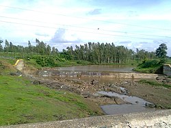
 River in Tapi district | |
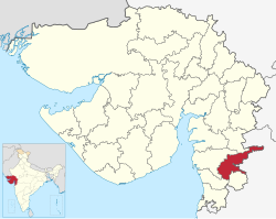
 Location of district in Gujarat | |
| Coordinates: 21°7′12″N 73°24′0″E / 21.12000°N 73.40000°E | |
| Country | |
| State | Gujarat |
| Headquarters | Vyara |
| Government | |
| • Body | Nagar Palika |
| Area | |
• Total | 3,139 km2 (1,212 sq mi) |
| Population (2011) | |
• Total | 807,022 |
| • Density | 260/km2 (670/sq mi) |
| Languages | |
| • Official | Gujarati, Hindi |
| Time zone | UTC+5:30 (IST) |
| Area code(s) | 02624, 02625, 02626, 02628 |
| Vehicle registration | GJ 26 |
| Website | tapi |
Tapi district is one of the 33 districts of Gujarat state in western India. It has seven talukas: Vyara, Songadh, Nizar, Valod, Uchhal, Dolavan and Kukarmunda. Vyara town is the district headquarters. Tapi has 523 villages and two municipalities. The district was formed in 2007 out of some talukas that were separated from Surat district.[1]
Demographics
[edit]| Year | Pop. | ±% p.a. |
|---|---|---|
| 1901 | 155,894 | — |
| 1911 | 166,720 | +0.67% |
| 1921 | 167,361 | +0.04% |
| 1931 | 183,989 | +0.95% |
| 1941 | 221,965 | +1.89% |
| 1951 | 263,380 | +1.73% |
| 1961 | 329,134 | +2.25% |
| 1971 | 457,502 | +3.35% |
| 1981 | 527,971 | +1.44% |
| 1991 | 626,979 | +1.73% |
| 2001 | 719,634 | +1.39% |
| 2011 | 807,022 | +1.15% |
| source:[2] | ||
According to the 2011 census, Tapi district has a population of 807,022,[3] roughly equal to the nation of Comoros[4] or the US state of South Dakota.[5] This gives it a ranking of 484th in India (out of a total of 640).[3] The district has a population density of 234 inhabitants per square kilometre (610/sq mi) .[3] Its population growth rate over the decade 2001-2011 was 12.07%.[3] Tapi has a sex ratio of 1004 females for every 1000 males,[3] and a literacy rate of 69.23%. 9.85% of the population lives in urban areas. Scheduled Castes and Scheduled Tribes make up 1.01% and 84.18% of the population respectively.[3]
At the time of the 2011 Census of India, 49.09% of the population in the district spoke Gujarati, 14.53% Gamit, 9.96% Bhili, 8.02% Vasava, 5.96% Chaudhari, 2.86% Hindi, 2.86% Marathi and 1.96% Kukna as their first language.[7]
Politics
[edit]| District | No. | Constituency | Name | Party | Remarks | |
|---|---|---|---|---|---|---|
| Tapi | 171 | Vyara (ST) | Mohanbhai Konkani | Bharatiya Janata Party | ||
| 172 | Nizar (ST) | Dr. Jairam Gamit | Bharatiya Janata Party | |||
Notable persons
[edit]- Suresh Joshi (1921–1986) Writer and academic. Born in Valod.[8]
- Amarsinh Bhilabhai Chaudhary, Former Chief Minister of Gujarat (July 1985 to December 1989)
Tourism
[edit]The District shares Purna Wildlife Sanctuary with the Districts of Dang and Nandurbar, the latter of which is in Maharashtra. The sanctuary is a part of the Dangs' Forest.[9][10]
References
[edit]- ^ "About Tapi". Government of Gujarat.
- ^ Decadal Variation In Population Since 1901
- ^ a b c d e f "District Census Hand Book – Tapi" (PDF). Census of India. Registrar General and Census Commissioner of India.
- ^ US Directorate of Intelligence. "Country Comparison:Population". Archived from the original on 13 June 2007. Retrieved 1 October 2011.
Comoros 794,683 July 2011 est.
- ^ "2010 Resident Population Data". U. S. Census Bureau. Retrieved 30 September 2011.
South Dakota 814,180
- ^ "Population by Religion - Gujarat". censusindia.gov.in. Registrar General and Census Commissioner of India. 2011.
- ^ a b "Table C-16 Population by Mother Tongue: Gujarat". censusindia.gov.in. Registrar General and Census Commissioner of India.
- ^ Mohan, Sarala Jag, Chapter 4: "Twentieth-Century Gujarati Literature" (Google books link), in Natarajan, Nalini, and Emanuel Sampath Nelson, editors, Handbook of Twentieth-century Literatures of India, Westport, Connecticut: Greenwood Publishing Group, 1996, ISBN 978-0-313-28778-7, retrieved 10 December 2008
- ^ "Mahal Eco Campsite". Gujarat Tourism. Retrieved 25 January 2017.
- ^ Trivedi, Pranav; Soni, V. C. (2006). "Significant bird records and local extinctions in Purna and Ratanmahal Wildlife Sanctuaries, Gujarat, India" (PDF). Forktail. Retrieved 14 November 2022.
External links
[edit]- Official website
- Tapi district Panchayat website
 Geographic data related to Tapi district at OpenStreetMap


