Gmina Czerwieńsk: Difference between revisions
bot: standardizing |
No edit summary |
||
| (20 intermediate revisions by 15 users not shown) | |||
| Line 1: | Line 1: | ||
{{Infobox |
{{Infobox settlement |
||
| name = Gmina Czerwieńsk |
| name = Gmina Czerwieńsk |
||
| other_name = Czerwieńsk Commune |
| other_name = Czerwieńsk Commune |
||
| settlement_type = [[Gmina]] |
| settlement_type = [[Gmina]] |
||
| ⚫ | |||
| image_flag = |
| image_flag = |
||
| image_shield = POL Czerwieńsk COA.svg |
| image_shield = POL Czerwieńsk COA.svg |
||
| image_map = |
| image_map =Zielonogorski-czerwiensk.gif |
||
| map_caption = Gmina Czerwieńsk in Zielona Góra County |
|||
| coordinates = {{coord|52|0|56|N|15|24|18|E|region:PL|display=inline,title}} |
|||
| ⚫ | |||
| subdivision_type = Country |
| subdivision_type = Country |
||
| subdivision_name = {{POL}} |
| subdivision_name = {{POL}} |
||
| Line 12: | Line 14: | ||
| subdivision_name1 = [[Lubusz Voivodeship|Lubusz]] |
| subdivision_name1 = [[Lubusz Voivodeship|Lubusz]] |
||
| subdivision_type2 = [[Powiat|County]] |
| subdivision_type2 = [[Powiat|County]] |
||
| subdivision_name2 = [[Zielona Góra County]] |
| subdivision_name2 = [[Zielona Góra County|Zielona Góra]] |
||
| ⚫ | |||
| ⚫ | |||
| area_total_km2 = 195.93 |
| area_total_km2 = 195.93 |
||
| population_as_of = 2019-06-30<ref>{{cite web |title=Population. Size and structure and vital statistics in Poland by territorial division in 2019. As of 30th June|url=https://stat.gov.pl/en/topics/population/population/population-size-and-structure-and-vital-statistics-in-poland-by-territorial-division-in-2019-as-of-30th-june,3,26.html|website=stat.gov.pl|publisher=Statistics Poland|date=2019-10-15|access-date=2020-04-11}}</ref> |
|||
| population_total = |
| population_total = 10004 |
||
| population_density_km2 = auto |
| population_density_km2 = auto |
||
| population_urban = |
| population_urban = 4041 |
||
| population_rural = 5963 |
|||
| population_blank1_title = Rural |
|||
| ⚫ | |||
| population_blank1 = 5362 |
|||
}} |
|||
| ⚫ | |||
| latd = 52 |
|||
| latm = 0 |
|||
| lats = 56 |
|||
| latNS = N |
|||
| longd = 15 |
|||
| longm = 24 |
|||
| longs = 18 |
|||
| longEW = E |
|||
| ⚫ | |||
| ⚫ | |||
__NOTOC__ |
__NOTOC__ |
||
'''Gmina Czerwieńsk''' is an urban-rural [[gmina]] (administrative district) in [[Zielona Góra County]], [[Lubusz Voivodeship]], in western [[Poland]]. Its seat is the town of [[Czerwieńsk]], which lies approximately {{convert|11|km|mi|0}} north-west of [[Zielona Góra]]. |
'''Gmina Czerwieńsk''' is an urban-rural [[gmina]] (administrative district) in [[Zielona Góra County]], [[Lubusz Voivodeship]], in western [[Poland]]. Its seat is the town of [[Czerwieńsk]], which lies approximately {{convert|11|km|mi|0}} north-west of [[Zielona Góra]]. |
||
The gmina covers an area of {{convert|195.93|km2|sqmi|1}}, and as of |
The gmina covers an area of {{convert|195.93|km2|sqmi|1}}, and as of 2019 its total population is 10,004. |
||
The gmina contains part of the [[protected area]] called [[Gryżyna Landscape Park]]. |
The gmina contains part of the [[protected area]] called [[Gryżyna Landscape Park]]. |
||
| Line 42: | Line 37: | ||
==Neighbouring gminas== |
==Neighbouring gminas== |
||
Gmina Czerwieńsk is bordered by the gminas of [[Gmina Bytnica|Bytnica]], [[Gmina Dąbie, Lubusz Voivodeship|Dąbie]], [[Gmina Krosno Odrzańskie|Krosno Odrzańskie]], [[Gmina Skąpe|Skąpe]], [[Gmina Sulechów|Sulechów]], [[Gmina Świdnica, Lubusz Voivodeship|Świdnica]] and [[Gmina Zielona Góra|Zielona Góra]]. |
Gmina Czerwieńsk is bordered by the gminas of [[Gmina Bytnica|Bytnica]], [[Gmina Dąbie, Lubusz Voivodeship|Dąbie]], [[Gmina Krosno Odrzańskie|Krosno Odrzańskie]], [[Gmina Skąpe|Skąpe]], [[Gmina Sulechów|Sulechów]], [[Gmina Świdnica, Lubusz Voivodeship|Świdnica]] and [[Gmina Zielona Góra|Zielona Góra]]. |
||
==Twin towns – sister cities== |
|||
{{See also|List of twin towns and sister cities in Poland}} |
|||
Gmina Czerwieńsk is [[Sister city|twinned]] with:<ref>{{cite web |title=Miasta partnerskie|url=http://www.czerwiensk.pl/asp/pl_start.asp?typ=14&sub=5&menu=48&strona=1#gora_tytul|website=czerwiensk.pl|publisher=Gmina Czerwieńsk|language=pl|access-date=2021-03-03}}</ref> |
|||
*{{flagicon|GER}} [[Drebkau]], Germany |
|||
*{{flagicon|RUS}} [[Suzdal]], Russia |
|||
==References== |
==References== |
||
{{reflist}} |
|||
*[http://www.stat.gov.pl/gus/45_655_PLK_HTML.htm Polish official population figures 2006] |
|||
<br> |
|||
{{Gmina Czerwieńsk}} |
{{Gmina Czerwieńsk}} |
||
{{Zielona Góra County}} |
{{Zielona Góra County}} |
||
{{DEFAULTSORT:Gmina Czerwiensk}} |
|||
[[Category:Gminas in Lubusz Voivodeship|Czerwiensk]] |
[[Category:Gminas in Lubusz Voivodeship|Czerwiensk]] |
||
[[Category:Zielona Góra County |
[[Category:Zielona Góra County]] |
||
[[it:Czerwieńsk]] |
|||
[[nl:Czerwieńsk (gemeente)]] |
|||
[[pl:Gmina Czerwieńsk]] |
|||
[[pt:Comuna de Czerwieńsk]] |
|||
[[ru:Гмина Червеньск]] |
|||
Latest revision as of 21:22, 28 June 2024
Gmina Czerwieńsk
Czerwieńsk Commune | |
|---|---|
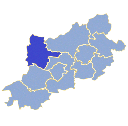
 Gmina Czerwieńsk in Zielona Góra County | |
| Coordinates (Czerwieńsk): 52°0′56″N 15°24′18″E / 52.01556°N 15.40500°E | |
| Country | |
| Voivodeship | Lubusz |
| County | Zielona Góra |
| Seat | Czerwieńsk |
| Area | |
• Total | 195.93 km2 (75.65 sq mi) |
| Population (2019-06-30[1]) | |
• Total | 10,004 |
| • Density | 51/km2 (130/sq mi) |
| • Urban | 4,041 |
| • Rural | 5,963 |
| Website | czerwiensk |
Gmina Czerwieńsk is an urban-rural gmina (administrative district) in Zielona Góra County, Lubusz Voivodeship, in western Poland. Its seat is the town of Czerwieńsk, which lies approximately 11 kilometres (7 mi) north-west of Zielona Góra.
The gmina covers an area of 195.93 square kilometres (75.6 sq mi), and as of 2019 its total population is 10,004.
The gmina contains part of the protected area called Gryżyna Landscape Park.
Villages
[edit]Apart from the town of Czerwieńsk, Gmina Czerwieńsk contains the villages and settlements of Będów, Bródki, Dobrzęcin, Laski, Leśniów Mały, Leśniów Wielki, Nietków, Nietkowice, Płoty, Sudoł, Sycowice, Wysokie and Zagórze.
Neighbouring gminas
[edit]Gmina Czerwieńsk is bordered by the gminas of Bytnica, Dąbie, Krosno Odrzańskie, Skąpe, Sulechów, Świdnica and Zielona Góra.
Twin towns – sister cities
[edit]Gmina Czerwieńsk is twinned with:[2]
References
[edit]- ^ "Population. Size and structure and vital statistics in Poland by territorial division in 2019. As of 30th June". stat.gov.pl. Statistics Poland. 2019-10-15. Retrieved 2020-04-11.
- ^ "Miasta partnerskie". czerwiensk.pl (in Polish). Gmina Czerwieńsk. Retrieved 2021-03-03.


