Mount Kikizi: Difference between revisions
Appearance
Content deleted Content added
m .clarification |
m Added short description #article-add-desc Tags: Mobile edit Mobile app edit iOS app edit |
||
| (15 intermediate revisions by 14 users not shown) | |||
| Line 1: | Line 1: | ||
{{Short description|Mountain in Burundi}} |
|||
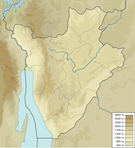
'''Mount Kikizi''' is one of the highest mountains in the small African country of [[Burundi]]. Its summit is at a height of 2,145 m (7,038 ft). The mountain shands in the country's southeast, between the towns of [[Rutana]] and [[Kinyinya]]. |
|||
{{Infobox mountain |
|||
| name = Kikizi |
|||
| photo = |
|||
| photo_caption = |
|||
| photo_size = |
|||
| elevation_m = 2145 |
|||
| elevation_ref = |
|||
| prominence_m = |
|||
| prominence_ref = |
|||
| map = Burundi |
|||
| map_caption = |
|||
| map_size = |
|||
| label_position = bottom |
|||
| listing = |
|||
| location = |
|||
| range = |
|||
| coordinates = {{Coord|3.9046191|S|29.8525079|E|source:dewiki_region:BI_scale:50000_type:mountain|format=dms|display=inline,title}} |
|||
| coordinates_ref = |
|||
| topo = |
|||
| type = |
|||
| age = |
|||
| last_eruption = |
|||
| first_ascent = |
|||
| easiest_route = |
|||
}} |
|||
'''Mount Kikizi''' is one of the highest mountains in [[Burundi]]. Its summit is at a height of 2,145 m (7,038 ft). The mountain stands in the country's southeast, between the towns of [[Rutana]] and [[Kinyinya]].<ref>{{cite book|last1=Fitzpatrick|first1=M|last2=Parkinson|first2=T|last3=Ray|first3=N|title=East Africa|date=2006|publisher=[[Lonely Planet]]|location=[[Footscray, Victoria]]|isbn=9781741042863|url-access=registration|url=https://archive.org/details/lonelyplaneteast00mary}}</ref> |
|||
A spring emanating from Mount Kikizi, the [[Ruvyironza River|Ruvyironza]], was identified by [[Burkhart Waldecker]] as being the source of the [[White Nile]].<ref name="travguide">{{cite book|title=Traveler's Guide to the Belgian Congo and Ruanda-Urundi|date=1956|publisher=Tourist Bureau for the Belgian Congo and Ruanda-Urundi|page=72|url=https://books.google.com/books?id=5T0UAAAAIAAJ}}</ref><ref>{{cite book|last1=Mugoti|first1=Godfrey|title=Africa (a-z).|date=2009|publisher=Lulu.com|isbn=9781435728905|page=81|url={{Google books|Plvuddy_4NYC|page=81|keywords=Ruvyironza|text=|plainurl=y}}|language=en}}</ref>{{Self-published inline|date=December 2017}} |
|||
==References== |
==References== |
||
{{reflist}} |
|||
* Fitzpatrick, M., Parkinson, T., & Ray, N. (2006) ''East Africa.'' Footscray, VIC: [[Lonely Planet]]. |
|||
[[Category:Mountains of Burundi|Kikizi]] |
[[Category:Mountains of Burundi|Kikizi]] |
||
{{Burundi-geo-stub}} |
{{Burundi-geo-stub}} |
||
[[sv:Kikiziberget]] |
|||
Latest revision as of 09:21, 3 July 2024
| Kikizi | |
|---|---|
| Highest point | |
| Elevation | 2,145 m (7,037 ft) |
| Coordinates | 3°54′17″S 29°51′09″E / 3.9046191°S 29.8525079°E |
Mount Kikizi is one of the highest mountains in Burundi. Its summit is at a height of 2,145 m (7,038 ft). The mountain stands in the country's southeast, between the towns of Rutana and Kinyinya.[1]
A spring emanating from Mount Kikizi, the Ruvyironza, was identified by Burkhart Waldecker as being the source of the White Nile.[2][3][self-published source?]
References
[edit]- ^ Fitzpatrick, M; Parkinson, T; Ray, N (2006). East Africa. Footscray, Victoria: Lonely Planet. ISBN 9781741042863.
- ^ Traveler's Guide to the Belgian Congo and Ruanda-Urundi. Tourist Bureau for the Belgian Congo and Ruanda-Urundi. 1956. p. 72.
- ^ Mugoti, Godfrey (2009). Africa (a-z). Lulu.com. p. 81. ISBN 9781435728905.

