Curepe: Difference between revisions
Appearance
Content deleted Content added
Darryl0173 (talk | contribs) No edit summary |
+ref section - still needs references |
||
| (11 intermediate revisions by 9 users not shown) | |||
| Line 1: | Line 1: | ||
{{Unreferenced |
{{Unreferenced|date=December 2009}} |
||
{{Infobox |
{{Infobox settlement |
||
<!-- See Template:Infobox settlement for additional fields and descriptions --> |
|||
|official_name = Curepe |
|official_name = Curepe |
||
|other_name = |
|other_name = |
||
| Line 6: | Line 7: | ||
|nickname = |
|nickname = |
||
|settlement_type = Town<!--For Town or Village (Leave blank for the default City)--> |
|settlement_type = Town<!--For Town or Village (Leave blank for the default City)--> |
||
|motto = |
|||
|image_skyline = T&T Curepe.jpg |
|image_skyline = T&T Curepe.jpg |
||
|imagesize = |
|imagesize = |
||
| Line 31: | Line 31: | ||
|pushpin_map_caption = |
|pushpin_map_caption = |
||
|pushpin_mapsize = |
|pushpin_mapsize = |
||
|subdivision_type = |
|subdivision_type = Region |
||
|subdivision_name = [[ |
|subdivision_name = [[Tunapuna–Piarco]] |
||
|subdivision_type1 = Country |
|subdivision_type1 = Country |
||
|subdivision_name1 = [[Trinidad and Tobago]] |
|subdivision_name1 = [[Trinidad and Tobago]] |
||
| Line 75: | Line 75: | ||
|population_as_of = |
|population_as_of = |
||
|population_footnotes = |
|population_footnotes = |
||
|population_note = |
|population_note = |
||
|population_total = |
|population_total = |
||
|population_density_km2 = |
|population_density_km2 = |
||
| Line 93: | Line 93: | ||
|timezone_DST = |
|timezone_DST = |
||
|utc_offset_DST = |
|utc_offset_DST = |
||
|latd=|latm=|latNS=|longd=|longm=| longEW=|coordinates_display= |
|||
|elevation_footnotes = <!--for references: use <ref> </ref> tags--> |
|elevation_footnotes = <!--for references: use <ref> </ref> tags--> |
||
|elevation_m = |
|elevation_m = |
||
| Line 108: | Line 107: | ||
}} |
}} |
||
'''Curepe''' |
'''Curepe''' is a town in the [[East–West Corridor]] of [[Trinidad and Tobago]]. It is located west of [[Saint Augustine, Trinidad and Tobago|St Augustine]] and east of [[Saint Joseph (Trinidad and Tobago)|St Joseph]]. Curepe adjacents the St. Augustine campus of the [[University of the West Indies]]. Many of the students attending the university live in Curepe. |
||
Curepe began as a crossroads, where the [[Southern Main Road]] ran south. Although the Southern Main Road has largely been supplanted by highways, Curepe remains an important transportation hub for private taxis and [[maxi taxi]]s which ply the route south to [[San Fernando, Trinidad and Tobago|San Fernando]] and [[Chaguanas]]. |
Curepe began as a crossroads, where the [[Southern Main Road]] ran south. Although the Southern Main Road has largely been supplanted by highways, Curepe remains an important transportation hub for private taxis and [[maxi taxi]]s which ply the route south to [[San Fernando, Trinidad and Tobago|San Fernando]] and [[Chaguanas]]. |
||
Curepe is administered by the [[ |
Curepe is administered by the [[Tunapuna–Piarco Regional Corporation]]. |
||
==References== |
|||
{{reflist}} |
|||
{{Authority control}} |
|||
{{Coord|10|38|N|61|24|W|region:TT_type:city|display=title}} |
{{Coord|10|38|N|61|24|W|region:TT_type:city|display=title}} |
||
{{commons category}} |
|||
[[Category:Populated places in Trinidad and Tobago]] |
[[Category:Populated places in Trinidad and Tobago]] |
||
{{Trinidad-geo-stub}} |
{{Trinidad-geo-stub}} |
||
Latest revision as of 18:55, 6 July 2024
Curepe | |
|---|---|
Town | |
 Curepe | |
 | |
| Region | Tunapuna–Piarco |
| Country | Trinidad and Tobago |
| Time zone | UTC−4 (AST) |
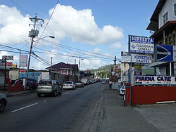
Curepe is a town in the East–West Corridor of Trinidad and Tobago. It is located west of St Augustine and east of St Joseph. Curepe adjacents the St. Augustine campus of the University of the West Indies. Many of the students attending the university live in Curepe.
Curepe began as a crossroads, where the Southern Main Road ran south. Although the Southern Main Road has largely been supplanted by highways, Curepe remains an important transportation hub for private taxis and maxi taxis which ply the route south to San Fernando and Chaguanas.
Curepe is administered by the Tunapuna–Piarco Regional Corporation.
References
[edit]10°38′N 61°24′W / 10.633°N 61.400°W
Wikimedia Commons has media related to Curepe.
