Murata (San Marino): Difference between revisions
Appearance
Content deleted Content added
m Robot - Speedily moving category San Marino (city) to Category:City of San Marino per CFDS. |
m fixing formatting and/or removing unknown params with AWB |
||
| (20 intermediate revisions by 13 users not shown) | |||
| Line 1: | Line 1: | ||
{{Short description|Curazia of the City of San Marino, San Marino}} |
|||
{| class="infobox bordered" cellpadding="4" style="font-size: 100%; width: 20em;" |
|||
{{Use British English|date=February 2024}} |
|||
|- align="center" style="font-size: medium; color:white; background-color:#0000CD; padding:2px;" | |
|||
{{Use dmy dates|date=February 2024}} |
|||
| colspan="5" | '''Murata''' |
|||
{{More citations needed|date=February 2024}} |
|||
|- |
|||
{{Infobox settlement |
|||
| align="center" colspan="2" style="background-color: white;" | |
|||
| name = Murata |
|||
[[Image:San_Marino_San Marino.png|200px]] |
|||
| settlement_type = ''[[Curazia]]'' |
|||
|- align="left" style="vertical-align: left;" |
|||
| image_skyline = |
|||
|| [[Country]]: || {{flagicon|San Marino}} [[San Marino]] |
|||
| image_caption = |
|||
|- align="left" style="vertical-align: left;" |
|||
| image_map = San Marino San Marino.png |
|||
| map_caption = Location of the ''[[Municipalities of San Marino|castello]]'' of the [[City of San Marino]] within San Marino |
|||
|- align="left" style="vertical-align: left;" |
|||
| pushpin_map = San Marino |
|||
|| [[Population]]: || ? |
|||
| pushpin_map_caption = Location within San Marino |
|||
|- align="left" style="vertical-align: left;" |
|||
| subdivision_type = Country |
|||
| ⚫ | |||
| subdivision_name = {{flag|San Marino}} |
|||
|- align="left" style="vertical-align: left;" |
|||
| subdivision_type1 = [[Municipalities of San Marino|Castello]] |
|||
|| [[Elevation]]: || 500 [[Above mean sea level|amsl]] |
|||
| subdivision_name1 = {{flagicon image|Coat of arms of the city of San Marino.svg}} [[City of San Marino|San Marino]] |
|||
|- align="left" style="vertical-align: left;" |
|||
| population_total = |
|||
|| [[Postal code]]: || 47890 |
|||
| population_footnotes = |
|||
|- align="left" style="vertical-align: left;" |
|||
| area_total_km2 = |
|||
|| [[Telephone number|Dialing code]]: ||+378 (0549) |
|||
| area_footnotes = |
|||
|- align="left" style="vertical-align: left;" |
|||
| population_density_km2 = auto |
|||
|| [[Demonym|Gentilic]]: || muratesi |
|||
| ⚫ | |||
|- align="left" style="vertical-align: left;" |
|||
| elevation_m = 500 |
|||
|| [[Website]] || ? |
|||
| timezone = CET |
|||
| ⚫ | |||
| utc_offset = +1 |
|||
'''Murata''' is a village (''curazia'') in the middle of [[San Marino]]. It belongs to the municipality of [[City of San Marino|San Marino]] and is its most populated ''curazia''. |
|||
| timezone_DST = CEST |
|||
| utc_offset_DST = +2 |
|||
| postal_code_type = Postal code |
|||
| postal_code = 47890 |
|||
| area_code = +378 (0549) |
|||
| blank_name = [[Köppen climate classification|Climate]] |
|||
| blank_info = [[Oceanic climate|Cfb]] |
|||
| population_demonym = muratesi |
|||
| website = |
|||
| pop_est_as_of = 2005 |
|||
| population_est = 1580 |
|||
| ⚫ | |||
'''Murata''' is a {{Lang|it|[[curazia]]}} of [[San Marino]], in the {{Lang|it|[[Municipalities of San Marino|castello]]}} of the [[City of San Marino]].<ref name="Elezioni">{{cite web |last1=Rattini |first1=Maurizio |last2=Venturini |first2=Gian Carlo |last3=Volpinari |first3=Antonio L. |date=21 March 1997 |title=Regolamento per la disciplina della campagna elttorale |url=http://www.elezioni.sm/index.php?id=299 |archiveurl=https://web.archive.org/web/20090805215911/http://www.elezioni.sm/index.php?id=299 |archivedate=5 August 2009 |accessdate=14 February 2020 |website=Elezioni |language=it}}</ref><ref>{{Cite web |title=Città di San Marino |trans-title=City of San Marino |url=https://www.sanmarinoweb.it/castelli-di-san-marino/citta-di-san-marino/ |access-date=9 February 2024 |website=San Marino Web |language=it-SM}}</ref> It is the most populated ''curazia'' of the City of San Marino. |
|||
==Geography== |
==Geography== |
||
| Line 32: | Line 45: | ||
The local football team is the [[S.S. Murata|Murata]]. |
The local football team is the [[S.S. Murata|Murata]]. |
||
== |
== References == |
||
{{reflist}} |
|||
*[[City of San Marino|San Marino]] (city) |
|||
*[[Cà Berlone]] |
|||
*[[Canepa]] |
|||
*[[Casole]] |
|||
*[[Castellaro (San Marino)|Castellaro]] |
|||
*[[Montalbo (San Marino)|Montalbo]] |
|||
*[[Santa Mustiola]] |
|||
{{Curazie of San Marino}} |
{{Curazie of San Marino}} |
||
[[Category:Curazie in San Marino]] |
[[Category:Curazie in San Marino]] |
||
[[Category:City of San Marino]] |
[[Category:Geography of the City of San Marino]] |
||
{{SanMarino-geo-stub}} |
{{SanMarino-geo-stub}} |
||
[[it:Murata (San Marino)]] |
|||
[[sco:Murata (San Marino)]] |
|||
Latest revision as of 18:11, 9 July 2024
This article needs additional citations for verification. (February 2024) |
Murata | |
|---|---|
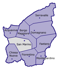
 Location of the castello of the City of San Marino within San Marino | |
| Coordinates: 43°55′12.12″N 12°27′3.72″E / 43.9200333°N 12.4510333°E | |
| Country | |
| Castello | |
| Elevation | 500 m (1,600 ft) |
| Population | |
• Estimate (2005) | 1,580 |
| Demonym | muratesi |
| Time zone | UTC+1 (CET) |
| • Summer (DST) | UTC+2 (CEST) |
| Postal code | 47890 |
| Area code | +378 (0549) |
| Climate | Cfb |
Murata is a curazia of San Marino, in the castello of the City of San Marino.[1][2] It is the most populated curazia of the City of San Marino.
Geography
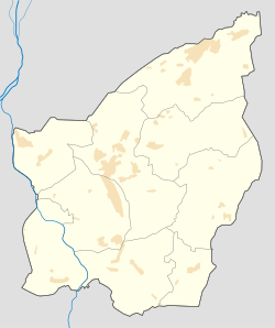
[edit]The village is situated on the hills between the City of San Marino and Fiorentino. It has a quarter named Fonte dell'Ovo, seat of the sport plants of Murata.
Sport
[edit]The local football team is the Murata.
References
[edit]- ^ Rattini, Maurizio; Venturini, Gian Carlo; Volpinari, Antonio L. (21 March 1997). "Regolamento per la disciplina della campagna elttorale". Elezioni (in Italian). Archived from the original on 5 August 2009. Retrieved 14 February 2020.
- ^ "Città di San Marino" [City of San Marino]. San Marino Web (in Italian). Retrieved 9 February 2024.


