Uckerfelde: Difference between revisions
Appearance
Content deleted Content added
m robot Adding: vo:Uckerfelde |
mNo edit summary |
||
| (32 intermediate revisions by 24 users not shown) | |||
| Line 1: | Line 1: | ||
{{Infobox German location |
|||
| ⚫ | |||
|name = Uckerfelde |
|||
|image_photo = Bietikow church.jpg |
|||
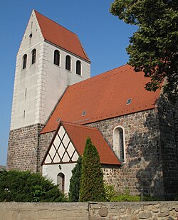
|image_caption = Church in Bietikow |
|||
|image_coa = kein |
|||
|coordinates = {{coord|53.265|13.95|format=dms|display=inline,title}} |
|||
|image_plan = Uckerfelde in UM.png |
|||
|state = Brandenburg |
|||
|district = Uckermark |
|||
|Amt = Gramzow |
|||
|elevation = 78 |
|||
|area = 45.93 |
|||
|postal_code = 17291 |
|||
|area_code = 039858, 039861 |
|||
|licence = UM |
|||
|Gemeindeschlüssel = 12 0 73 578 |
|||
|website = [http://www.amtgramzow.de/ www.amtgramzow.de] |
|||
|mayor = Peter Gerhardt<ref>[https://wahlen.brandenburg.de/wahlen/de/kommunalwahlen/ergebnisse/buergermeisterwahlen/ergebnisse/~12073000 Landkreis Uckermark Wahl der Bürgermeisterin / des Bürgermeisters]. Retrieved 10 July 2024.</ref> |
|||
|leader_term = 2024–29 |
|||
}} |
|||
| ⚫ | |||
==Demography== |
|||
| ⚫ | |||
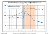
[[File:Bevölkerungsentwicklung Uckerfelde.pdf|thumb|200px|left|Development of population since 1875 within the current boundaries (Blue line: Population; Dotted line: Comparison to population development of Brandenburg state; Grey background: Time of Nazi rule; Red background: Time of communist rule)]] |
|||
| ⚫ | |||
{{historical populations |
|||
[[Category:Towns in Brandenburg]] |
|||
|align=none | cols=3 | percentages=pagr |
|||
|title = Uckerfelde: Population development <br>within the current boundaries (2017)<ref>Detailed data sources are to be found in the Wikimedia Commons.[http://commons.wikimedia.org/wiki/Category:Population_projection_Brandenburg Population Projection Brandenburg at Wikimedia Commons]</ref> |
|||
| 1875 | 1646 |
|||
| 1890 | 1646 |
|||
| 1910 | 1647 |
|||
| 1925 | 1756 |
|||
| 1933 | 1594 |
|||
| 1939 | 1655 |
|||
| 1946 | 2493 |
|||
| 1950 | 2631 |
|||
| 1964 | 2044 |
|||
| 1971 | 1938 |
|||
| 1981 | 1324 |
|||
| 1985 | 1242 |
|||
| 1989 | 1207 |
|||
| 1990 | 1191 |
|||
| 1991 | 1178 |
|||
| 1992 | 1164 |
|||
| 1993 | 1166 |
|||
| 1994 | 1173 |
|||
| 1995 | 1173 |
|||
| 1996 | 1158 |
|||
| 1997 | 1157 |
|||
| 1998 | 1152 |
|||
| 1999 | 1153 |
|||
| 2000 | 1129 |
|||
| 2001 | 1126 |
|||
| 2002 | 1118 |
|||
| 2003 | 1085 |
|||
| 2004 | 1095 |
|||
| 2005 | 1089 |
|||
| 2006 | 1087 |
|||
| 2007 | 1061 |
|||
| 2008 | 1054 |
|||
| 2009 | 1046 |
|||
| 2010 | 1053 |
|||
| 2011 | 1008 |
|||
| 2012 | 997 |
|||
| 2013 | 992 |
|||
| 2014 | 953 |
|||
| 2015 | 948 |
|||
| 2016 | 943 |
|||
| 2017 | 931 |
|||
}} |
|||
==References== |
|||
[[de:Uckerfelde]] |
|||
{{Reflist}} |
|||
[[eo:Uckerfelde]] |
|||
[[nl:Uckerfelde]] |
|||
| ⚫ | |||
[[ru:Уккерфельде]] |
|||
{{Authority control}} |
|||
[[vo:Uckerfelde]] |
|||
[[Category:Localities in Uckermark (district)]] |
|||
| ⚫ | |||
Latest revision as of 14:17, 10 July 2024
Uckerfelde | |
|---|---|
 Church in Bietikow | |
Location of Uckerfelde within Uckermark district  | |
| Coordinates: 53°15′54″N 13°57′00″E / 53.265°N 13.95°E | |
| Country | Germany |
| State | Brandenburg |
| District | Uckermark |
| Municipal assoc. | Gramzow |
| Government | |
| • Mayor (2024–29) | Peter Gerhardt[1] |
| Area | |
• Total | 45.93 km2 (17.73 sq mi) |
| Elevation | 78 m (256 ft) |
| Population (2022-12-31)[2] | |
• Total | 954 |
| • Density | 21/km2 (54/sq mi) |
| Time zone | UTC+01:00 (CET) |
| • Summer (DST) | UTC+02:00 (CEST) |
| Postal codes | 17291 |
| Dialling codes | 039858, 039861 |
| Vehicle registration | UM |
| Website | www.amtgramzow.de |
Uckerfelde is a municipality in the Uckermark district of Brandenburg, Germany.
Demography
[edit]
|
|
|
References
[edit]- ^ Landkreis Uckermark Wahl der Bürgermeisterin / des Bürgermeisters. Retrieved 10 July 2024.
- ^ "Bevölkerungsentwicklung und Bevölkerungsstandim Land Brandenburg Dezember 2022" (PDF). Amt für Statistik Berlin-Brandenburg (in German). June 2023.
- ^ Detailed data sources are to be found in the Wikimedia Commons.Population Projection Brandenburg at Wikimedia Commons


