Gossas: Difference between revisions
Appearance
Content deleted Content added
No edit summary Tags: Mobile edit Mobile web edit |
No edit summary Tags: Mobile edit Mobile web edit |
||
| (One intermediate revision by the same user not shown) | |||
| Line 7: | Line 7: | ||
|native_name = <!-- for cities whose native name is not in English --> |
|native_name = <!-- for cities whose native name is not in English --> |
||
|nickname = |
|nickname = |
||
|settlement_type = Town<!--For Town or Village (Leave blank for the default City)--> |
|settlement_type = Town and [[Communes of Senegal|commune]]<!--For Town or Village (Leave blank for the default City)--> |
||
|total_type = Town and [[Communes of Senegal|commune]] |
|||
|motto = |
|motto = |
||
<!-- images and maps -----------> |
<!-- images and maps -----------> |
||
| Line 86: | Line 87: | ||
}} |
}} |
||
'''Gossas''' is a town and urban commune in [[Fatick Region]] in western [[Senegal]], about 90 km from the capital. |
'''Gossas''' is a town and urban commune in [[Fatick Region]] in western [[Senegal]], about 90 km from the capital [[Dakar]]. |
||
== Transport == |
== Transport == |
||
Latest revision as of 00:55, 21 July 2024
Gossas | |
|---|---|
Town and commune | |
| Coordinates: 14°30′N 16°04′W / 14.500°N 16.067°W | |
| Country | |
| Region | Fatick Region |
| Department | Gossas |
| Area | |
• Town and commune | 5.601 km2 (2.163 sq mi) |
| Elevation | 21 m (69 ft) |
| Population (2023 census)[1] | |
• Town and commune | 15,630 |
| • Density | 2,800/km2 (7,200/sq mi) |
| Time zone | UTC+0 (GMT) |
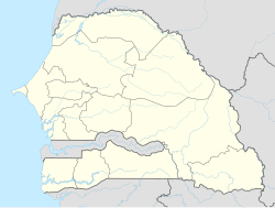
Gossas is a town and urban commune in Fatick Region in western Senegal, about 90 km from the capital Dakar.
Transport
[edit]The town is served by a station on the Dakar-Niger Railway.
See also
[edit]References
[edit]- ^ a b Citypopulation.de Population and area of Gossas Commune
14°30′00″N 16°04′00″W / 14.50000°N 16.06667°W

