Lake Guyon: Difference between revisions
Appearance
Content deleted Content added
m gm, link |
m Moving Category:Lakes of Canterbury, New Zealand to Category:Lakes of the Canterbury Region per Wikipedia:Categories for discussion/Speedy |
||
| (22 intermediate revisions by 16 users not shown) | |||
| Line 1: | Line 1: | ||
{{Short description|Lake in New Zealand}} |
|||
| ⚫ | |||
{{Use New Zealand English|date=April 2024}} |
|||
| ⚫ | |||
| ⚫ | |||
| ⚫ | |||
| ⚫ | |||
| caption_lake = |
|||
| ⚫ | |||
| ⚫ | |||
| alt = Lake Guyon |
|||
| caption_bathymetry= |
|||
| caption = Lake Guyon |
|||
| ⚫ | |||
| ⚫ | |||
| ⚫ | |||
| |
| caption_bathymetry = |
||
| ⚫ | |||
| ⚫ | |||
| ⚫ | |||
| outflow = |
|||
| |
| type = |
||
| ⚫ | |||
| ⚫ | |||
| pushpin_map=New Zealand South Island |
|||
| length = |
|||
| pushpin_map_alt= Location of Lake Guyon |
|||
| width = |
|||
| |
| outflow = |
||
| catchment = |
|||
| depth = 24 metres |
|||
| ⚫ | |||
| ⚫ | |||
| |
| length = |
||
| |
| width = |
||
| |
| area = |
||
| depth = {{convert|24|m|abbr=on}} |
|||
| ⚫ | |||
| ⚫ | |||
| volume = |
|||
| residence_time = |
|||
| shore = |
|||
| ⚫ | |||
}} |
}} |
||
'''Lake Guyon''' is in the [[Canterbury |
'''Lake Guyon''' is in the [[Canterbury, New Zealand|Canterbury]] region in the [[South Island]] of [[New Zealand]]. The stream draining the lake feeds into the [[Waiau Uwha River]].<ref>{{cite map |publisher = Land Information New Zealand |title = LEWIS |date = 2001 |series = 260-M31}}</ref> |
||
|publisher = Land Information New Zealand |
|||
|title = LEWIS |
|||
|url = |
|||
|edition = |
|||
|date = 2001 |
|||
|year = |
|||
|cartography= |
|||
|scale = |
|||
|series = 260-M31 |
|||
|page = |
|||
|section = |
|||
|inset = |
|||
|accessdate = 2009-11-17 |
|||
|isbn = |
|||
|id = |
|||
}}</ref> |
|||
It was within the boundaries of the former [[St James Station, New Zealand|St James Station]] but it is now surrounded by public conservation land. A [[backcountry hut]] is on its northern shore. The lake is administered by the [[Department of Conservation (New Zealand)|Department of Conservation]] as a scenic reserve.<ref>[http://www.doc.govt.nz/upload/documents/about-doc/role/policies-and-plans/m31003_lakeguyonscenicres.pdf DoC] - LAKE GUYON SCENIC RESERVE</ref> |
It was within the boundaries of the former [[St James Station, New Zealand|St James Station]] but it is now surrounded by public conservation land. A [[backcountry hut]] is on its northern shore. The lake is administered by the [[Department of Conservation (New Zealand)|Department of Conservation]] as a scenic reserve.<ref>[http://www.doc.govt.nz/upload/documents/about-doc/role/policies-and-plans/m31003_lakeguyonscenicres.pdf DoC] {{webarchive|url=https://web.archive.org/web/20081017024705/http://www.doc.govt.nz/upload/documents/about-doc/role/policies-and-plans/m31003_lakeguyonscenicres.pdf |date=2008-10-17 }} - LAKE GUYON SCENIC RESERVE</ref> |
||
==See also== |
==See also== |
||
| Line 50: | Line 39: | ||
==External links== |
==External links== |
||
*[http://www.doc.govt.nz/parks-and-recreation/places-to-visit/canterbury/ |
*[http://www.doc.govt.nz/parks-and-recreation/places-to-visit/canterbury/north-canterbury-and-arthurs-pass/st-james-conservation-area/ Department of Conservation] - St James Conservation Area |
||
*[ |
*[https://maps.google.com/maps?f=q&source=s_q&hl=en&q=Lake+Guyon,+Hanmer+Springs,+Canterbury+7392,+New+Zealand&sll=37.0625,-95.677068&sspn=49.71116,79.013672&ie=UTF8&hq=&hnear=Lake+Guyon&cd=1&geocode=FWO4ev0d9WRKCg&split=0&t=h&z=13 Lake Guyon] at [[Google Maps]] |
||
[[Category:Lakes of |
[[Category:Lakes of the Canterbury Region|Guyon]] |
||
[[Category:Canterbury, New Zealand]] |
|||
Latest revision as of 20:36, 22 July 2024
| Lake Guyon | |
|---|---|
 Lake Guyon | |
| Location | Canterbury, New Zealand |
| Coordinates | 42°17′23″S 172°38′52″E / 42.289818°S 172.647657°E |
| Basin countries | New Zealand |
| Average depth | 24 m (79 ft) |
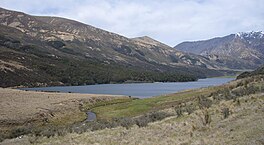
Lake Guyon is in the Canterbury region in the South Island of New Zealand. The stream draining the lake feeds into the Waiau Uwha River.[1]
It was within the boundaries of the former St James Station but it is now surrounded by public conservation land. A backcountry hut is on its northern shore. The lake is administered by the Department of Conservation as a scenic reserve.[2]
See also
[edit]References
[edit]- ^ LEWIS (Map). 260-M31. Land Information New Zealand. 2001.
- ^ DoC Archived 2008-10-17 at the Wayback Machine - LAKE GUYON SCENIC RESERVE
External links
[edit]- Department of Conservation - St James Conservation Area
- Lake Guyon at Google Maps

