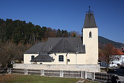
Furth an der Triesting: Difference between revisions
Appearance
Content deleted Content added
Zackmann08 (talk | contribs) |
No edit summary |
||
| (5 intermediate revisions by 5 users not shown) | |||
| Line 2: | Line 2: | ||
| name = Furth an der Triesting |
| name = Furth an der Triesting |
||
| native_name = |
| native_name = |
||
| settlement_type = |
| settlement_type = [[Municipality (Austria)|Municipality]] |
||
<!-- Images --> |
<!-- Images --> |
||
| image_skyline = |
| image_skyline = Furth Kirche.JPG |
||
| imagesize = |
| imagesize = |
||
| image_caption = |
| image_caption = Church of Saint Mary Magdalene |
||
| image_shield = AUT Furth an der Triesting COA.jpg |
| image_shield = AUT Furth an der Triesting COA.jpg |
||
| shield_size = 80x110px |
| shield_size = 80x110px |
||
| Line 31: | Line 31: | ||
<!-- Leaders --> |
<!-- Leaders --> |
||
| leader_title = [[Burgomaster|Mayor]] |
| leader_title = [[Burgomaster|Mayor]] |
||
| leader_name = |
| leader_name = Alois Riegler |
||
| leader_party = |
| leader_party = [[ÖVP]] |
||
| leader_title1 = |
| leader_title1 = |
||
| leader_name1 = |
| leader_name1 = |
||
<!-- Statistics --> |
<!-- Statistics --> |
||
| area_footnotes = {{Austria population Wikidata|area_footnotes}} |
|||
| area_total_km2 = 64.24 |
|||
| area_total_km2 = {{Austria population Wikidata|area_total_km2}} |
|||
| area_metro_km2 = |
| area_metro_km2 = |
||
| elevation_m = 422 |
| elevation_m = 422 |
||
| elevation_max_m = |
| elevation_max_m = |
||
| elevation_min_m = |
| elevation_min_m = |
||
| population_as_of = {{Austria population Wikidata|population_as_of}} |
|||
| population_total = 849 |
|||
| population_footnotes = {{Austria population Wikidata|population_footnotes}} |
|||
| population_as_of = 1 January 2016 |
|||
| population_total = {{Austria population Wikidata|population_total}} |
|||
| population_footnotes = <ref>[http://www.statistik.at/wcm/idc/idcplg?IdcService=GET_NATIVE_FILE&RevisionSelectionMethod=LatestReleased&dDocName=080904 Statistik Austria - Bevölkerung zu Jahresbeginn 2002-2016 nach Gemeinden (Gebietsstand 1.1.2016)] for Furth an der Triesting. </ref> |
|||
| population_urban = |
| population_urban = |
||
| population_metro = |
| population_metro = |
||
| Line 64: | Line 65: | ||
'''Furth an der Triesting''' is a town in the district of [[Baden (district of Austria)|Baden]] in [[Lower Austria]] in [[Austria]]. |
'''Furth an der Triesting''' is a town in the district of [[Baden (district of Austria)|Baden]] in [[Lower Austria]] in [[Austria]]. |
||
Furth an der Triesting was governed by the citizen list We for Furth (WFF) until 2020. The WFF will join the [[Austrian People's Party|ÖVP]] in 2019 and will receive all mandates in the municipal council in the 2020 elections. |
|||
The [[Social Democratic Party of Austria|SPÖ]] had a mandate until 2020, since 2020 the party has been insignificant in the city. |
|||
==Populations== |
==Populations== |
||
| Line 84: | Line 89: | ||
== External links == |
== External links == |
||
{{ |
{{commons category|Furth an der Triesting}} |
||
{{Cities and towns in Baden (district)}} |
{{Cities and towns in Baden (district)}} |
||
{{authority control}} |
|||
| ⚫ | |||
| ⚫ | |||
[[Category:Gutenstein Alps]] |
[[Category:Gutenstein Alps]] |
||
Latest revision as of 11:28, 25 July 2024
Furth an der Triesting | |
|---|---|
 Church of Saint Mary Magdalene | |
| Coordinates: 47°58′N 15°58′E / 47.967°N 15.967°E | |
| Country | Austria |
| State | Lower Austria |
| District | Baden |
| Government | |
| • Mayor | Alois Riegler (ÖVP) |
| Area | |
• Total | 64.24 km2 (24.80 sq mi) |
| Elevation | 422 m (1,385 ft) |
| Population (2018-01-01)[2] | |
• Total | 862 |
| • Density | 13/km2 (35/sq mi) |
| Time zone | UTC+1 (CET) |
| • Summer (DST) | UTC+2 (CEST) |
| Postal code | 2564 |
| Area code | 02674 |
| Website | www.furth-triesting.at |
Furth an der Triesting is a town in the district of Baden in Lower Austria in Austria.
Furth an der Triesting was governed by the citizen list We for Furth (WFF) until 2020. The WFF will join the ÖVP in 2019 and will receive all mandates in the municipal council in the 2020 elections.
The SPÖ had a mandate until 2020, since 2020 the party has been insignificant in the city.
Populations
[edit]| Year | Pop. | ±% |
|---|---|---|
| 1939 | 967 | — |
| 1951 | 885 | −8.5% |
| 1961 | 820 | −7.3% |
| 1971 | 809 | −1.3% |
| 1981 | 753 | −6.9% |
| 1991 | 745 | −1.1% |
| 2001 | 795 | +6.7% |
| 2001 | 795 | +0.0% |
| 2011 | 823 | +3.5% |
References
[edit]- ^ "Dauersiedlungsraum der Gemeinden Politischen Bezirke und Bundesländer - Gebietsstand 1.1.2018". Statistics Austria. Retrieved 10 March 2019.
- ^ "Einwohnerzahl 1.1.2018 nach Gemeinden mit Status, Gebietsstand 1.1.2018". Statistics Austria. Retrieved 9 March 2019.
External links
[edit]Wikimedia Commons has media related to Furth an der Triesting.


