Pundibari: Difference between revisions
Do general fixes and cleanup. - using AWB (9084) |
GreenC bot (talk | contribs) Move 1 url. Wayback Medic 2.5 per WP:URLREQ#goo.gl |
||
| (31 intermediate revisions by 14 users not shown) | |||
| Line 1: | Line 1: | ||
{{Use Indian English|date=December 2014}} |
|||
{{Use dmy dates|date=August 2020}} |
|||
{{Infobox settlement |
{{Infobox settlement |
||
| name = Pundibari |
| name = Pundibari |
||
| native_name = |
| native_name = |
||
| native_name_lang = |
| native_name_lang = |
||
| other_name = |
| other_name = |
||
| nickname = |
| nickname = |
||
| settlement_type = |
| settlement_type = Village |
||
| image_skyline = |
| image_skyline = Pundibari Station Nameplate.JPG |
||
| image_alt = |
| image_alt = |
||
| image_caption = |
| image_caption = Pundibari Station Nameplate |
||
| pushpin_map = India West Bengal |
| pushpin_map = India West Bengal#India3#Asia |
||
| pushpin_label_position = right |
| pushpin_label_position = right |
||
| pushpin_map_alt = |
| pushpin_map_alt = |
||
| pushpin_map_caption = Location in West Bengal, India |
| pushpin_map_caption = Location in West Bengal, India |
||
| |
| coordinates = {{coord|26.408888|N|89.382372|E|display=inline,title}} |
||
| latm = |
|||
| lats = |
|||
| latNS = N |
|||
| longd = 89.11 |
|||
| longm = |
|||
| longs = |
|||
| longEW = E |
|||
| coordinates_display = inline,title |
|||
| subdivision_type = Country |
| subdivision_type = Country |
||
| subdivision_name = {{flag|India}} |
| subdivision_name = {{flag|India}} |
||
| Line 48: | Line 42: | ||
| demographics_type1 = Languages |
| demographics_type1 = Languages |
||
| demographics1_title1 = Official |
| demographics1_title1 = Official |
||
| demographics1_info1 = [[Bengali language|Bengali]]<ref name="wblangoff">{{cite web|title=Fact and Figures|url=https://wb.gov.in/portal/web/guest/facts-and-figures;jsessionid=JzdD9RHb7aMY5esZPtcsIVLy|website=www.wb.gov.in|accessdate=12 March 2019}}</ref><ref>{{cite web|title=52nd Report of the Commissioner for Linguistic Minorities in India|url=http://nclm.nic.in/shared/linkimages/NCLM52ndReport.pdf|website=nclm.nic.in|publisher=[[Ministry of Minority Affairs]]|accessdate=12 March 2019|page=85|url-status=dead|archiveurl=https://web.archive.org/web/20170525141614/http://nclm.nic.in/shared/linkimages/NCLM52ndReport.pdf|archivedate=25 May 2017}}</ref> |
|||
| demographics1_info1 = [[Bengali language|Bengali]], [[English language|English]] |
|||
| demographics1_title2 = Additional official |
|||
| demographics1_info2 = [[English language|English]]<ref name="wblangoff"/> |
|||
| timezone1 = [[Indian Standard Time|IST]] |
| timezone1 = [[Indian Standard Time|IST]] |
||
| utc_offset1 = +5:30 |
| utc_offset1 = +5:30 |
||
| postal_code_type = [[Postal Index Number|PIN]] |
| postal_code_type = [[Postal Index Number|PIN]] |
||
| postal_code = 736165 |
| postal_code = 736165 |
||
| registration_plate = |
| registration_plate = WB |
||
| blank1_name_sec1 = Nearest city |
| blank1_name_sec1 = Nearest city |
||
| blank1_info_sec1 = coochbehar |
| blank1_info_sec1 = coochbehar |
||
| Line 59: | Line 55: | ||
| footnotes = |
| footnotes = |
||
}} |
}} |
||
'''Pundibari''' is a |
'''Pundibari''' is a village in the [[Cooch Behar II]] [[Community development blocks in India|CD block]] in the [[Cooch Behar Sadar subdivision]] of the [[Cooch Behar district]] of [[West Bengal]], [[India]]. |
||
==Geography== |
==Geography== |
||
{{OSM Location map |
|||
| ⚫ | |||
| width=320| height=370| zoom=11 |
|||
|url = http://maps.yahoo.com/#mvt=m&lat=26.530199&lon=89.106583&zoom=15&q1=Pundibari |
|||
| coord={{coord|26|20|30|N|89|27|30|E}}| float=left|caption='''Places in the Cooch Behar Sadar subdivision in Cooch Behar district'''<br/>CT: census town, M: municipal town, R: rural/ urban centre, H: historical/ religious centre<br/>Owing to space constraints in the small map, the actual locations in a larger map may vary slightly |
|||
| ⚫ | |||
|mark-coord1={{coord|26|20|37|N|89|28|26|E}}| label-pos1=left|label1= Baisguri | numbered1=CT| mark-title1= [[Baisguri]] (CT)|label-color1= #800000 |label-size1=11| mark-size1=12|shape1=l-circle|shape-color1= #A40000 |shape-outline1=white|label-offset-x1=2 |
|||
| ⚫ | |||
|mark-coord2={{coord|26|23|30|N|89|29|45|E}}| label-pos2=left|label2=Baneswar| numbered2=CT| mark-title2= [[Baneswar]] (CT) |
|||
|accessdate = 2008-12-25 |
|||
|mark-coord3={{coord|26|20|10|N|89|28|44|E}}| label-pos3=right|label3=Chakchaka| numbered3=CT| mark-title3= [[Chakchaka]] (CT) |
|||
| ⚫ | }}</ref> It is the headquarters of Cooch Behar–II Community Development Block under [[Cooch Behar Sadar subdivision]] of the district.<ref name=distProfile2>{{cite web | url = http://coochbehar.gov.in/Htmfiles/dist_profile.html | title = Cooch Behar District profile | publisher = Official website of Cooch Behar district | accessdate = |
||
|mark-coord4={{coord|26|16|50|N|89|28|18|E}}| label-pos4=left|label4=Dhaliabari| numbered4=CT| mark-title4= [[Dhaliabari]] (CT) |
|||
|mark-coord5={{coord|26|18|49|N|89|27|50|E}}| label-pos5=left|label5=Guriahati| numbered5=CT| mark-title5= [[Guriahati]] (CT) |
|||
|mark-coord6={{coord|26|21|36|N|89|27|36|E}}| label-pos6=right|label6=Khagrabari| numbered6=CT| mark-title6= [[Khagrabari]] (CT) |
|||
|mark-coord7={{coord|26|18|55|N|89|28|15|E}}| label-pos7=right|label7=Kharimala Khagrabari| numbered7=CT| mark-title7= [[Kharimala Khagrabari]] (CT) |
|||
|mark-coord8={{coord|26|20|0|N|89|25|55|E}}| label-pos8=left|label8=Takagachh| numbered8=CT| mark-title8= [[Takagachh]] (CT) |
|||
|mark-coord9={{coord|26|19|40|N|89|27|3|E}}| label-pos9=right|label9=Cooch Behar| numbered9=M| mark-title9= [[Cooch Behar]] (M) | shape-color9=#800000 |
|||
|mark-coord10={{coord|26|14|37|N|89|29|10|E}}| label-pos10=right|label10=Dewanhat| numbered10=R| mark-title10= [[Dewanhat]] (R) | shape-color10= #C42222 |
|||
|mark-coord11={{coord|26|17|8|N|89|28|12|E}}| label-pos11=right|label11=Ghughumari| numbered11=R| mark-title11= [[Ghughumari]] (R)| shape-color11= #C42222 |
|||
|mark-coord12={{coord|26|26|15|N|89|22|30|E}}| label-pos12=right|label12=Kalarayerkuthi| numbered12=R| mark-title12= [[Kalarayerkuthi]] (R)| shape-color12= #C42222 |
|||
|mark-coord13={{coord|26|24|32|N|89|22|56|E}}| label-pos13=right|label13=Pundibari| numbered13=R| mark-title13= Pundibari (R) |shape-color13=black| label-size13=13|label-color13=black <!-- make the subject of the article stand out with black colors --> |
|||
|mark-coord14={{coord|26|17|40|N|89|27|20|E}}| label-pos14=left|label14=Gudam Maharaniganj| numbered14=H| mark-title14= [[Gudam Maharaniganj]] (H) |shape-color14=#AA6666 |
|||
|mark-coord15={{coord|26|19|37|N|89|26|18|E}}| label-pos15=left|label15=Cooch Behar Palace| numbered15=H| mark-title15= [[Cooch Behar Palace]] (H) |shape-color15=#AA6666 |
|||
|mark-coord16={{coord|26|21|48|N|89|22|41|E}}| label-pos16=right|label16= Madhupur Satra| numbered16=H| mark-title16= [[Madhupur Satra]] (H) |shape-color16=#AA6666 |
|||
|mark-coord17={{coord|26|22|7|N|89|22|4|E}}| label-pos17=top|label17= Haripur| numbered17=H| mark-title17= [[Haripur, Cooch Behar]] (H) |shape-color17=#AA6666 |
|||
|mark-coord18={{coord|26|22|11|N|89|29|59|E}}| label-pos18=right|label18= Baikunthapur| numbered18=H| mark-title18= [[Baikunthapur]] (H) |shape-color18=#AA6666 |
|||
|mark-coord19={{coord|26|23|12|N|89|30|45|E}}| label-pos19=right|label19= Sidheswari| numbered19=H| mark-title19= [[Sidheswari]] (H) |shape-color19=#AA6666 |
|||
|mark-coord23={{coord|26|18|0|N|89|29|0|E}}|label23= Mara| label-color23 = #77A1CB| label-angle23=-24| label-pos23=top| label-size23=10| mark-size23=0| mark-title23=none |
|||
|mark-coord24={{coord|26|17|40|N|89|30|30|E}}|label24= Torsha River| label-color24 = #77A1CB| label-angle24=34| label-pos24=top| label-size24=10| mark-size24=0| mark-title24=none}} |
|||
===Location=== |
|||
| ⚫ | |||
|url = https://www.google.com/maps?q=26.408890,89.382388&hl=en&gl=gb |
|||
| ⚫ | |||
| ⚫ | |||
|access-date = 11 February 2018 |
|||
| ⚫ | }}</ref> It is the headquarters of Cooch Behar–II Community Development Block under [[Cooch Behar Sadar subdivision]] of the district.<ref name=distProfile2>{{cite web | url = http://coochbehar.gov.in/Htmfiles/dist_profile.html | title = Cooch Behar District profile | publisher = Official website of Cooch Behar district | accessdate = 25 December 2008}}</ref> |
||
===Area overview=== |
|||
The map alongside shows the north-central part of the district. It has the highest level of urbanisation in an overwhelming rural district. 22.08% of the population of the Cooch Behar Sadar subdivision lives in the urban areas and 77.92% lives in the rural areas.<ref name="handbook">{{cite web |url = http://wbpspm.gov.in/publications/District%20Statistical%20Handbook |title = District Statistical Handbook 2013 Cooch Behar |work = Tables 2.2, 2.4b |publisher = Department of Planning and Statistics, Government of West Bengal |accessdate = 5 August 2020 |archive-url = https://web.archive.org/web/20190121045803/http://www.wbpspm.gov.in/publications/District%20Statistical%20Handbook |archive-date = 21 January 2019 |url-status = dead }}</ref> The entire district forms the flat [[alluvium|alluvial]] flood plains of mighty rivers.<ref>{{cite web | url = https://censusindia.gov.in/2011census/dchb/DCHB_A/19/1903_PART_A_DCHB_KOCH%20BIHAR.pdf| title = District Census Handbook, Koch Bihar, Series 20, Part XIIA| work= Census of India 2011, pages 17-21 Physical feafures| publisher = Directorate of Census Operations, West Bengal |accessdate = 5 August 2020}}</ref> |
|||
<small>Note: The map alongside presents some of the notable locations in the subdivision. All places marked in the map are linked in the larger full screen map.</small> |
|||
==Civic administration== |
|||
===Police station=== |
|||
There is a police station at Pundibari.<ref>{{cite web| url = http://coochbeharpolice.in/index.php/admin/police_stations |title =Police Stations | publisher= Cooch Behar Police | accessdate = 26 July 2020}}</ref><ref>{{cite web | url = http://coochbehar.nic.in/Htmfiles/CoB_Police.html | title = Police Stations under Cooch Behar district| publisher = Cooch Behar Police |accessdate = 26 July 2020}}</ref> |
|||
==Transport== |
|||
The Pundibari railway station is on the [[New Jalpaiguri–New Bongaigaon section]] of the [[Barauni–Guwahati line]].<ref>{{cite web | url = https://indiarailinfo.com/train/-train-rangiya-new-jalpaiguri-passenger-55714/7767/1374/444| title = Rangiya New Jalpaiguri Express | work= Time Table| publisher = IndiaRailInfo |accessdate = 10 August 2020}}</ref> |
|||
==Education== |
|||
[[Uttar Banga Krishi Vishwavidyalaya]] initially started functioning as a [[satellite campus]] of [[Bidhan Chandra Krishi Vishwavidyalaya]] and was formally established in 2001.<ref>{{cite web | url = http://www.ubkv.ac.in/ | title = Uttar Banga Krishi Vishwavidyalaya | publisher = UBKV |accessdate = 6 August 2020}}</ref> |
|||
==Healthcare== |
|||
Pundibari Rural Hospital, with 30 beds at Pundibari, is the major government medical facility in the Cooch Behar II CD block.<ref>{{cite web | url =https://www.wbhealth.gov.in/other_files/RH.pdf | title = Health & Family Welfare Department | work= Health Statistics – Rural Hospitals | publisher = Government of West Bengal|accessdate = 29 July 2020}}</ref> |
|||
==References== |
==References== |
||
{{reflist}} |
{{reflist|3}} |
||
{{Cooch Behar District}} |
{{Cooch Behar District}} |
||
| Line 77: | Line 117: | ||
{{ |
{{CoochBehar-geo-stub}} |
||
Latest revision as of 17:57, 25 July 2024
Pundibari | |
|---|---|
Village | |
 Pundibari Station Nameplate | |
| Coordinates: 26°24′32″N 89°22′57″E / 26.408888°N 89.382372°E | |
| Country | |
| State | West Bengal |
| District | Cooch Behar |
| Languages | |
| • Official | Bengali[1][2] |
| • Additional official | English[1] |
| Time zone | UTC+5:30 (IST) |
| PIN | 736165 |
| Vehicle registration | WB |
| Nearest city | coochbehar |
| Website | coochbehar |
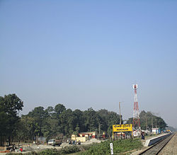
Pundibari is a village in the Cooch Behar II CD block in the Cooch Behar Sadar subdivision of the Cooch Behar district of West Bengal, India.
Geography
[edit]
3miles
CT: census town, M: municipal town, R: rural/ urban centre, H: historical/ religious centre
Owing to space constraints in the small map, the actual locations in a larger map may vary slightly
Location
[edit]Pundibari is located at 26°24′32″N 89°22′57″E / 26.408890°N 89.382388°E.[3] It is the headquarters of Cooch Behar–II Community Development Block under Cooch Behar Sadar subdivision of the district.[4]
Area overview
[edit]The map alongside shows the north-central part of the district. It has the highest level of urbanisation in an overwhelming rural district. 22.08% of the population of the Cooch Behar Sadar subdivision lives in the urban areas and 77.92% lives in the rural areas.[5] The entire district forms the flat alluvial flood plains of mighty rivers.[6]
Note: The map alongside presents some of the notable locations in the subdivision. All places marked in the map are linked in the larger full screen map.
Civic administration
[edit]Police station
[edit]There is a police station at Pundibari.[7][8]
Transport
[edit]The Pundibari railway station is on the New Jalpaiguri–New Bongaigaon section of the Barauni–Guwahati line.[9]
Education
[edit]Uttar Banga Krishi Vishwavidyalaya initially started functioning as a satellite campus of Bidhan Chandra Krishi Vishwavidyalaya and was formally established in 2001.[10]
Healthcare
[edit]Pundibari Rural Hospital, with 30 beds at Pundibari, is the major government medical facility in the Cooch Behar II CD block.[11]
References
[edit]- ^ a b "Fact and Figures". www.wb.gov.in. Retrieved 12 March 2019.
- ^ "52nd Report of the Commissioner for Linguistic Minorities in India" (PDF). nclm.nic.in. Ministry of Minority Affairs. p. 85. Archived from the original (PDF) on 25 May 2017. Retrieved 12 March 2019.
- ^ "Google maps location of Pundibari". Google maps. Retrieved 11 February 2018.
- ^ "Cooch Behar District profile". Official website of Cooch Behar district. Retrieved 25 December 2008.
- ^ "District Statistical Handbook 2013 Cooch Behar". Tables 2.2, 2.4b. Department of Planning and Statistics, Government of West Bengal. Archived from the original on 21 January 2019. Retrieved 5 August 2020.
- ^ "District Census Handbook, Koch Bihar, Series 20, Part XIIA" (PDF). Census of India 2011, pages 17-21 Physical feafures. Directorate of Census Operations, West Bengal. Retrieved 5 August 2020.
- ^ "Police Stations". Cooch Behar Police. Retrieved 26 July 2020.
- ^ "Police Stations under Cooch Behar district". Cooch Behar Police. Retrieved 26 July 2020.
- ^ "Rangiya New Jalpaiguri Express". Time Table. IndiaRailInfo. Retrieved 10 August 2020.
- ^ "Uttar Banga Krishi Vishwavidyalaya". UBKV. Retrieved 6 August 2020.
- ^ "Health & Family Welfare Department" (PDF). Health Statistics – Rural Hospitals. Government of West Bengal. Retrieved 29 July 2020.


