Billings Metropolitan Statistical Area: Difference between revisions
SounderBruce (talk | contribs) m fixing name and lead |
|||
| (33 intermediate revisions by 17 users not shown) | |||
| Line 1: | Line 1: | ||
{{Infobox settlement |
|||
| ⚫ | |||
| name = Billings metropolitan area |
|||
[[Image:Billings Metropolitan Area.png|thumb|right|300px|Location of the Billings Metropolitan Statistical Area in Montana.]] |
|||
| official_name = Billings, MT Metropolitan Statistical Area |
|||
The '''Billings Metropolitan Statistical Area''' is the largest and fastest growing metropolitan area in the U.S. state of [[Montana]]. Located in the south central portion of the state, its population was 166,855 at the 2014 United States Census estimate.<ref>{{cite web |url=http://factfinder.census.gov/faces/tableservices/jsf/pages/productview.xhtml?src%3Dbkmk |title=Archived copy |accessdate=2015-01-02 |deadurl=yes |archiveurl=https://www.webcitation.org/6gpGlyhlr?url=http://factfinder.census.gov/faces/tableservices/jsf/pages/productview.xhtml?src=bkmk |archivedate=2016-04-17 |df= }}</ref> |
|||
| native_name = |
|||
| settlement_type = [[Metropolitan statistical area]] |
|||
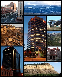
| image_skyline = File:Billings Montana Collage 11.jpg |
|||
| image_alt = |
|||
| imagesize = |
|||
| image_caption = Billings and surrounding area |
|||
| image_map = |
|||
{{maplink|frame=yes|plain=yes|frame-align=center|frame-width=290|frame-height=240|zoom=7|frame-coord={{coord|45.6000|-108.60000}} |
|||
| type1=shape|id1=Q192992|title1=Carbon County|stroke-color1=#007272|stroke-width1=0.5|fill1=#007272|fill-opacity1=0.4 |
|||
| type2=shape|id2=Q490750|title2=Stillwater County|stroke-color2=#007272|stroke-width2=0.5|fill2=#007272|fill-opacity2=0.4 |
|||
| type3=shape|id3=Q490283|title3=Yellowstone County|stroke-color3=#007272|stroke-width3=0.5|fill3=#007272|fill-opacity3=0.4 |
|||
| type4=shape|id4=Q166304|title4=City of Billings|stroke-color4=#0000FF|stroke-width4=0.5|fill4=#0000FF|fill-opacity4=0.4 |
|||
}} |
|||
| map_alt = Map of Billings Metropolitan Area |
|||
| map_caption = Interactive Map of Billings, MT [[Metropolitan Statistical Area|MSA]] |
|||
{{Col-begin}} |
|||
{{Col-break}} |
|||
{{leftlegend|#0000FF|[[Billings, Montana|City of Billings]]}} |
|||
{{leftlegend|#007272|Billings, MT [[Metropolitan Statistical Area|MSA]]}} |
|||
{{Col-end}} |
|||
| subdivision_type = [[List of sovereign states|Country]] |
|||
| subdivision_name = [[File:Flag of United States.svg|border|23px]] [[United States]] |
|||
| ⚫ | |||
| subdivision_type1 = [[U.S. state|State]] |
|||
| subdivision_name1 = [[File:Flag of Montana.svg|border|23px]] [[Montana]] |
|||
| subdivision_type2 = Principal city |
|||
| subdivision_name2 = [[Billings, Montana|Billings]] |
|||
| subdivision_type3 = Other cities |
|||
| subdivision_name3 = |
|||
| established_title = |
|||
| established_date = |
|||
| unit_pref = |
|||
| area_footnotes = |
|||
| area_total_sq_mi = |
|||
| elevation_max_footnotes = |
|||
| elevation_max_m = |
|||
| elevation_max_ft = |
|||
| elevation_min_footnotes = |
|||
| elevation_min_m = |
|||
| elevation_min_ft = |
|||
| population_as_of = |
|||
| population_footnotes = |
|||
| population_total = |
|||
| population_density_sq_mi= |
|||
| population_density_km2 = |
|||
| population_rank = |
|||
| demographics2_footnotes = |
|||
| demographics2_title1 = |
|||
| demographics2_info1 = |
|||
| timezone1 = [[Mountain Time Zone (North America)|MST]] |
|||
| utc_offset1 = -7 |
|||
| timezone1_DST = [[Mountain Time Zone (North America)|MDT]] |
|||
| utc_offset1_DST = -6 |
|||
| postal_code_type = |
|||
| postal_code = |
|||
| area_code_type = |
|||
| area_codes = |
|||
| website = <!-- {{URL|example.com}} --> |
|||
}} |
|||
The '''Billings metropolitan area''' is the largest metropolitan area in the U.S. state of [[Montana]]. It is centered around [[Billings, Montana|Billings]] in the south central portion of Montana and has a population is 184,167 as of 2020.<ref>{{Cite web|url=https://data.indystar.com/census/|title=United States 2020 Decennial Census}}</ref> |
|||
It |
It includes Carbon, Stillwater and Yellowstone counties,<ref>{{cite web |url=https://apps.bea.gov/regional/docs/msalist.cfm |title=BEA Statistical Areas|author=<!--Not stated--> |publisher=US Bureau of Economic Analysis |access-date=2020-07-26 }}</ref> and has one of the geographically largest trade, cultural, business and medical areas in the United States; this includes all of Montana. |
||
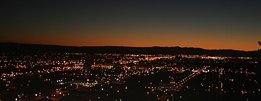
{{Panorama |
{{Panorama |
||
|image = Image:Billings |
|image = Image:Billings Montana MidTown.JPG |
||
|fullwidth = 2000 |
|fullwidth = 2000 |
||
|fullheight = 396 |
|fullheight = 396 |
||
|caption = Billings |
|caption = Billings midtown |
||
|height = 200 |
|height = 200 |
||
| Line 15: | Line 76: | ||
==Counties== |
==Counties== |
||
| ⚫ | |||
*[[Stillwater County, Montana|Stillwater]] |
|||
*[[Yellowstone County, Montana|Yellowstone]] |
*[[Yellowstone County, Montana|Yellowstone]] |
||
== |
==Places== |
||
=== |
===Over 100,000 inhabitants=== |
||
*[[Billings, Montana|Billings]] (Principal city) |
*[[Billings, Montana|Billings]] (Principal city) |
||
=== |
===1,000 to 10,000 inhabitants=== |
||
*[[Laurel, Montana|Laurel]] |
*[[Laurel, Montana|Laurel]] |
||
*[[Lockwood, Montana|Lockwood]] ([[census-designated place]]) |
*[[Lockwood, Montana|Lockwood]] ([[census-designated place]]) |
||
=== |
===Below 500 inhabitants=== |
||
*[[Bridger, Montana|Bridger]] |
|||
*[[Joliet, Montana|Joliet]] |
|||
*[[Worden, Montana|Worden]] (census-designated place) |
|||
===Places with fewer than 500 inhabitants=== |
|||
*[[Ballantine, Montana|Ballantine]] (census-designated place) |
*[[Ballantine, Montana|Ballantine]] (census-designated place) |
||
*[[Bearcreek, Montana|Bearcreek]] |
|||
*[[Belfry, Montana|Belfry]] (census-designated place) |
|||
*[[Broadview, Montana|Broadview]] |
|||
*[[Custer, Montana|Custer]] (census-designated place) |
|||
*[[Fromberg, Montana|Fromberg]] |
|||
*[[Huntley, Montana|Huntley]] (census-designated place) |
*[[Huntley, Montana|Huntley]] (census-designated place) |
||
*[[Shepherd, Montana|Shepherd]] (census-designated place) |
*[[Shepherd, Montana|Shepherd]] (census-designated place) |
||
===Unincorporated places=== |
|||
*[[Boyd, Montana|Boyd]] |
|||
*[[Edgar, Montana|Edgar]] |
|||
*[[Fox, Montana|Fox]] |
|||
*[[Luther, Montana|Luther]] |
|||
*[[Pompey's Pillar, Montana|Pompey's Pillar]] |
|||
*[[Roberts, Montana|Roberts]] |
|||
*[[Rockvale, Montana|Rockvale]] |
|||
*[[Roscoe, Montana|Roscoe]] |
|||
*[[Silesia, Montana|Silesia]] |
|||
*[[Warren, Montana|Warren]] |
|||
*[[Washoe, Montana|Washoe]] |
|||
*[[Homewood Park, Montana|Homewood Park]] |
|||
==Demographics== |
==Demographics== |
||
As of the [[census]]<ref name="GR2">{{cite web |url= |
As of the [[census]]<ref name="GR2">{{cite web |url=https://www.census.gov |publisher=[[United States Census Bureau]] |access-date=2008-01-31 |title=U.S. Census website }}</ref> of 2000, there are 138,904 people, 56,149 households, and 36,926 families residing within the MSA. The racial makeup of the MSA was 93.08% [[White (U.S. Census)|White]], 0.43% [[African American (U.S. Census)|African American]], 2.89% [[Native American (U.S. Census)|Native American]], 0.53% [[Asian (U.S. Census)|Asian]], 0.04% [[Pacific Islander (U.S. Census)|Pacific Islander]], 1.22% from [[Race (United States Census)|other races]], and 1.81% from two or more races. [[Hispanic (U.S. Census)|Hispanic]] or [[Latino (U.S. Census)|Latino]] of any race were 3.57% of the population. |
||
The median income for a household in the MSA was $34,433, and the median income for a family was $41,841. Males had a median income of $31,851 versus $20,756 for females. The [[per capita income]] for the MSA was $18,254. |
The median income for a household in the MSA was $34,433, and the median income for a family was $41,841. Males had a median income of $31,851 versus $20,756 for females. The [[per capita income]] for the MSA was $18,254. |
||
| Line 68: | Line 107: | ||
{{Montana}} |
{{Montana}} |
||
[[Category:Billings |
[[Category:Billings metropolitan area| ]] |
||
[[Category:Yellowstone County, Montana]] |
[[Category:Yellowstone County, Montana]] |
||
| ⚫ | |||
Latest revision as of 19:10, 7 August 2024
Billings metropolitan area | |
|---|---|
| Billings, MT Metropolitan Statistical Area | |
 Billings and surrounding area | |
 | |
| Coordinates: 45°47′01″N 108°30′22″W / 45.78361°N 108.50611°W | |
| Country | |
| State | |
| Principal city | Billings |
| Time zone | UTC-7 (MST) |
| • Summer (DST) | UTC-6 (MDT) |
The Billings metropolitan area is the largest metropolitan area in the U.S. state of Montana. It is centered around Billings in the south central portion of Montana and has a population is 184,167 as of 2020.[1]
It includes Carbon, Stillwater and Yellowstone counties,[2] and has one of the geographically largest trade, cultural, business and medical areas in the United States; this includes all of Montana.
Counties
[edit]Places
[edit]Over 100,000 inhabitants
[edit]- Billings (Principal city)
1,000 to 10,000 inhabitants
[edit]Below 500 inhabitants
[edit]- Ballantine (census-designated place)
- Huntley (census-designated place)
- Shepherd (census-designated place)
Demographics
[edit]As of the census[3] of 2000, there are 138,904 people, 56,149 households, and 36,926 families residing within the MSA. The racial makeup of the MSA was 93.08% White, 0.43% African American, 2.89% Native American, 0.53% Asian, 0.04% Pacific Islander, 1.22% from other races, and 1.81% from two or more races. Hispanic or Latino of any race were 3.57% of the population.
The median income for a household in the MSA was $34,433, and the median income for a family was $41,841. Males had a median income of $31,851 versus $20,756 for females. The per capita income for the MSA was $18,254.
See also
[edit]References
[edit]- ^ "United States 2020 Decennial Census".
- ^ "BEA Statistical Areas". US Bureau of Economic Analysis. Retrieved 2020-07-26.
- ^ "U.S. Census website". United States Census Bureau. Retrieved 2008-01-31.

