Baker, Nevada: Difference between revisions
m added historical population for 2000-2010 |
→top: update per gnis ... |
||
| (4 intermediate revisions by 3 users not shown) | |||
| Line 1: | Line 1: | ||
{{Use mdy dates|date=July 2023}} |
|||
{{Infobox settlement |
{{Infobox settlement |
||
|name = Baker, Nevada |
|name = Baker, Nevada |
||
| ⚫ | |||
|settlement_type = [[Census-designated place]] |
|settlement_type = [[Census-designated place]] |
||
|nickname = |
|||
|motto = |
|||
<!-- Images --> |
<!-- Images --> |
||
|image_skyline = BakerNevadaPostOfficeMarch2010.JPG |
|image_skyline = BakerNevadaPostOfficeMarch2010.JPG |
||
|imagesize = |
|imagesize = |
||
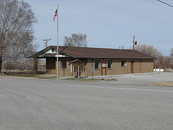
|image_caption = Post Office in Baker, March 2010 |
|image_caption = Post Office in Baker, March 2010 |
||
|image_flag = |
|||
|image_seal = |
|||
<!-- Maps --> |
<!-- Maps --> |
||
|pushpin_map = Nevada#USA |
|pushpin_map = Nevada#USA |
||
|pushpin_label = Baker |
|pushpin_label = Baker |
||
|pushpin_label_position = left |
|pushpin_label_position = left |
||
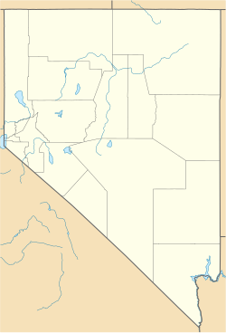
|pushpin_map_caption = Location of Baker |
|pushpin_map_caption = Location of Baker |
||
|pushpin_mapsize = |
|pushpin_mapsize = |
||
|image_map = |
|image_map = |
||
|map_caption = |
|map_caption = |
||
|image_map1 = |
|||
|mapsize1 = |
|||
|map_caption1 = |
|||
<!-- Location --> |
<!-- Location --> |
||
| |
|subdivision_type = Country |
||
|subdivision_name = United States |
|subdivision_name = United States |
||
|subdivision_type1 = [[U.S. state|State]] |
|subdivision_type1 = [[U.S. state|State]] |
||
| Line 35: | Line 26: | ||
|leader_title = <!-- Mayor --> |
|leader_title = <!-- Mayor --> |
||
|leader_name = |
|leader_name = |
||
|leader_title1 = |
|||
|leader_name1 = |
|||
|established_title = |
|established_title = |
||
|established_date = |
|established_date = |
||
<!-- Area --> |
<!-- Area --> |
||
|unit_pref = Imperial |
|unit_pref = Imperial |
||
|area_footnotes = <ref name="TigerWebMapServer">{{cite web|title=ArcGIS REST Services Directory|url=https://tigerweb.geo.census.gov/arcgis/rest/services/TIGERweb/Places_CouSub_ConCity_SubMCD/MapServer|publisher=United States Census Bureau|accessdate=September 19, 2022}}</ref> |
|area_footnotes = <ref name="TigerWebMapServer">{{cite web|title=ArcGIS REST Services Directory|url=https://tigerweb.geo.census.gov/arcgis/rest/services/TIGERweb/Places_CouSub_ConCity_SubMCD/MapServer|publisher=United States Census Bureau|accessdate=September 19, 2022}}</ref> |
||
| |
|area_total_sq_mi = 0.91 |
||
| ⚫ | |||
| ⚫ | |||
|area_total_km2 = 2.35 |
|area_total_km2 = 2.35 |
||
|area_land_km2 = 2.34 |
|area_land_km2 = 2.34 |
||
|area_water_km2 = 0.01 |
|area_water_km2 = 0.01 |
||
<!-- Population --> |
<!-- Population --> |
||
|population_as_of = [[2020 United States Census|2020]] |
|population_as_of = [[2020 United States Census|2020]] |
||
|population_footnotes = |
|population_footnotes = |
||
|population_total = 41 |
|population_total = 41 |
||
| ⚫ | |||
|population_density_km2 = 17.51 |
|population_density_km2 = 17.51 |
||
<!-- General information --> |
<!-- General information --> |
||
|timezone = [[Pacific Time Zone|Pacific (PST)]] |
|timezone = [[Pacific Time Zone|Pacific (PST)]] |
||
| |
|utc_offset = −8 |
||
|timezone_DST = PDT |
|timezone_DST = PDT |
||
| |
|utc_offset_DST = −7 |
||
|elevation_footnotes = |
|elevation_footnotes = <ref name=gnis/> |
||
|elevation_ft = |
|elevation_ft = 5309 |
||
|coordinates = {{coord|39 |
|coordinates = {{coord|39|00|52|N|114|07|35|W|type:city_region:US-NV|display=inline,title}} |
||
<!-- Area/postal codes & others --> |
<!-- Area/postal codes & others --> |
||
|postal_code_type = [[ZIP code]] |
|postal_code_type = [[ZIP code]] |
||
| Line 70: | Line 58: | ||
|blank_info = 32-04100 |
|blank_info = 32-04100 |
||
|blank1_name = [[Geographic Names Information System|GNIS]] feature ID |
|blank1_name = [[Geographic Names Information System|GNIS]] feature ID |
||
|blank1_info = 2629977<ref name= |
|blank1_info = 2629977<ref name=gnis>{{gnis|2629977}}</ref> |
||
|website = |
|website = |
||
|footnotes = |
|footnotes = |
||
|pop_est_as_of = |
|||
|pop_est_footnotes = |
|||
|population_est = |
|||
|area_total_sq_mi = 0.91 |
|||
|area_land_sq_mi = 0.90 |
|||
| ⚫ | |||
| ⚫ | |||
}} |
}} |
||
'''Baker''' is a [[census-designated place]] in southeastern [[White Pine County, Nevada|White Pine County]], [[Nevada]], United States.<ref name= |
'''Baker''' is a [[census-designated place]] in southeastern [[White Pine County, Nevada|White Pine County]], [[Nevada]], United States.<ref name=gnis/> It is located {{convert|5|mi|km}} east of the main entrance of [[Great Basin National Park]] at the junction of [[Nevada State Route 487|State Routes 487]] and [[Nevada State Route 488|488]]. The town is named after an early settler, George W. Baker. Its population at the [[2010 United States Census|2010 census]] was 68.<ref name="Census 2010">{{cite web| url=http://factfinder.census.gov/bkmk/table/1.0/en/DEC/10_DP/G001/1600000US3204100| archive-url=https://archive.today/20200212185818/http://factfinder.census.gov/bkmk/table/1.0/en/DEC/10_DP/G001/1600000US3204100| url-status=dead| archive-date=February 12, 2020| title=Geographic Identifiers: 2010 Demographic Profile Data (G001): Baker CDP, Nevada| publisher=U.S. Census Bureau, American Factfinder| access-date=January 28, 2013}}</ref> |
||
==Demographics== |
|||
{{US Census population |
|||
| 2000 = 382 |
|||
| 2000n = |
|||
| 2010 = 68 |
|||
| 2020 = 41 |
|||
| footnote = U.S. Decennial Census<ref name="DecennialCensus">{{cite web|url=http://www.census.gov/prod/www/decennial.html|title=Census of Population and Housing|publisher=Census.gov|accessdate=June 4, 2016}}</ref> |
|||
}} |
|||
==Education== |
|||
Public education is provided through the White Pine County School District. Baker 3-6 Elementary school is the only school in Baker. |
Public education is provided through the White Pine County School District. Baker 3-6 Elementary school is the only school in Baker. |
||
==Commercial operations== |
|||
[[File:2014-08-09 15 04 34 View north along Nevada State Route 487 (Baker Road) about 6.1 miles north of the Utah state line in Baker, Nevada.JPG|thumb|left|Main Street ([[Nevada State Route 487|State Route 487]]) in Baker, August 2014]] |
[[File:2014-08-09 15 04 34 View north along Nevada State Route 487 (Baker Road) about 6.1 miles north of the Utah state line in Baker, Nevada.JPG|thumb|left|Main Street ([[Nevada State Route 487|State Route 487]]) in Baker, August 2014]] |
||
[[Lodging]]s in the community include the Stargazer Inn, which includes the Bristlecone General Store, located at the center of town; the End of the Trail…er, Baker's original bed-and-fix-your-own-breakfast, located at the edge of town; and the [[Border Inn]], located just east of town on the [[Utah]]/Nevada border. |
|||
Several artists reside in Baker, including Terry Marasco, Margaret Pense,<ref>{{cite web |title=Horsehair Art |publisher=End of the Trail…er |url=http://www.outside-art.com/HorsehairArt.html |access-date=2011-06-09 |archive-url=https://web.archive.org/web/20110715023610/http://www.outside-art.com/HorsehairArt.html |archive-date=15 July 2011 |url-status=dead }}</ref> Bill and Kathy Rountree,<ref>{{cite web| title= Welcome to SilverJack IronWorks| url= http://www.silverjackironworks.com/welcome.htm| access-date= 2011-06-09| archive-url= https://web.archive.org/web/20110716071759/http://www.silverjackironworks.com/welcome.htm| archive-date= 16 July 2011| url-status= dead}}</ref> and "Doc" Sherman.<ref name="latenight"/> |
|||
==Notable people== |
==Notable people== |
||
| Line 106: | Line 72: | ||
==In popular culture== |
==In popular culture== |
||
In January 1997, ''[[Late Show with David Letterman]]'' produced a segment on the town,<ref name="latenight">{{cite web |url=http://greatbasinpark.com/post_art.htm |title=Baker Is Famous For Being Funny |
In January 1997, ''[[Late Show with David Letterman]]'' produced a segment on the town,<ref name="latenight">{{cite web |url=http://greatbasinpark.com/post_art.htm |title=Baker Is Famous For Being Funny... |publisher=Great Basin Business & Tourism Council |access-date=2011-06-09| archive-url= https://web.archive.org/web/20110711123412/http://greatbasinpark.com/post_art.htm| archive-date= 11 July 2011 | url-status= live}}</ref> with the show's [[Biff Henderson]] touring the area and ending his narrative on Baker with the quote, "It's quiet, peaceful, beautiful and the people are friendly." |
||
==See also== |
==See also== |
||
| Line 118: | Line 84: | ||
{{Wikivoyage|Baker (Nevada)}} |
{{Wikivoyage|Baker (Nevada)}} |
||
{{commons category-inline|Baker, Nevada}} |
{{commons category-inline|Baker, Nevada}} |
||
{{White Pine County, Nevada}} |
{{White Pine County, Nevada}} |
||
{{authority control}} |
{{authority control}} |
||
[[Category:Census-designated places in White Pine County, Nevada]] |
[[Category:Census-designated places in White Pine County, Nevada]] |
||
Latest revision as of 22:49, 12 August 2024
Baker, Nevada | |
|---|---|
 Post Office in Baker, March 2010 | |
| Coordinates: 39°00′52″N 114°07′35″W / 39.01444°N 114.12639°W | |
| Country | United States |
| State | Nevada |
| County | White Pine |
| Area | |
• Total | 0.91 sq mi (2.35 km2) |
| • Land | 0.90 sq mi (2.34 km2) |
| • Water | 0.00 sq mi (0.01 km2) |
| Elevation | 5,309 ft (1,618 m) |
| Population (2020) | |
• Total | 41 |
| • Density | 45.35/sq mi (17.51/km2) |
| Time zone | UTC−8 (Pacific (PST)) |
| • Summer (DST) | UTC−7 (PDT) |
| ZIP code | 89311 |
| Area code | 775 |
| FIPS code | 32-04100 |
| GNIS feature ID | 2629977[2] |
Baker is a census-designated place in southeastern White Pine County, Nevada, United States.[2] It is located 5 miles (8.0 km) east of the main entrance of Great Basin National Park at the junction of State Routes 487 and 488. The town is named after an early settler, George W. Baker. Its population at the 2010 census was 68.[3]
Public education is provided through the White Pine County School District. Baker 3-6 Elementary school is the only school in Baker.

Notable people
[edit]Prominent people from Baker include Calvin Quate, a professor of electrical engineering at Stanford University who is famous for the invention of the atomic force microscope.
In popular culture
[edit]In January 1997, Late Show with David Letterman produced a segment on the town,[4] with the show's Biff Henderson touring the area and ending his narrative on Baker with the quote, "It's quiet, peaceful, beautiful and the people are friendly."
See also
[edit]References
[edit]- ^ "ArcGIS REST Services Directory". United States Census Bureau. Retrieved September 19, 2022.
- ^ a b c U.S. Geological Survey Geographic Names Information System: Baker, Nevada
- ^ "Geographic Identifiers: 2010 Demographic Profile Data (G001): Baker CDP, Nevada". U.S. Census Bureau, American Factfinder. Archived from the original on February 12, 2020. Retrieved January 28, 2013.
- ^ "Baker Is Famous For Being Funny..." Great Basin Business & Tourism Council. Archived from the original on July 11, 2011. Retrieved June 9, 2011.
External links
[edit]![]() Media related to Baker, Nevada at Wikimedia Commons
Media related to Baker, Nevada at Wikimedia Commons


