Dalaman: Difference between revisions
m Corrected country name from Turkey to Türkiye as per UN name change. Tag: Reverted |
New mayor after local elections Tags: Manual revert Mobile edit Mobile web edit |
||
| (3 intermediate revisions by 2 users not shown) | |||
| Line 1: | Line 1: | ||
{{about|the town and district center|the airport|Dalaman Airport}} |
{{about|the town and district center|the airport|Dalaman Airport}} |
||
{{Infobox |
{{Infobox Turkey place |
||
| type = metro district |
| type = metro district |
||
| name = Dalaman |
| name = Dalaman |
||
| Line 22: | Line 22: | ||
}} |
}} |
||
[[File:Sarsala Bay in Dalaman from above.jpg|thumb|Sarsala Bay in Dalaman]] |
[[File:Sarsala Bay in Dalaman from above.jpg|thumb|Sarsala Bay in Dalaman]] |
||
'''Dalaman''' is a municipality and [[Districts of |
'''Dalaman''' is a municipality and [[Districts of Turkey|district]] of [[Muğla Province]], [[Turkey]].<ref>[https://www.e-icisleri.gov.tr/Anasayfa/MulkiIdariBolumleri.aspx Büyükşehir İlçe Belediyesi], Turkey Civil Administration Departments Inventory. Retrieved 19 September 2023.</ref> Its area is 608 km<sup>2</sup>,<ref>{{cite web|url=https://www.harita.gov.tr/uploads/files-folder/il_ilce_alanlari.xlsx|title=İl ve İlçe Yüz ölçümleri|publisher=General Directorate of Mapping|access-date=19 September 2023}}</ref> and its population is 47,482 (2022).<ref name=tuik>{{Cite web |title=Address-based population registration system (ADNKS) results dated 31 December 2022, Favorite Reports|url=https://biruni.tuik.gov.tr/medas/?kn=95&locale=en |access-date=19 September 2023|publisher=[[TÜİK]]|language=en|format=XLS}}</ref> It is situated on the southwestern coast of Turkey. |
||
[[Dalaman Stream]] (''Dalaman çayı'') forms much of the western border of the district, where its neighbors are Köyceğiz and [[Ortaca]] districts. The town of Dalaman is located in the coastal plain, whereas the rest of the district – towards Fethiye district on the coast and towards the high mountains on the northern border to [[Denizli Province]] – is upland, dominated by the valleys of the Dalaman Stream's eastern [[tributaries]]. |
[[Dalaman Stream]] (''Dalaman çayı'') forms much of the western border of the district, where its neighbors are Köyceğiz and [[Ortaca]] districts. The town of Dalaman is located in the coastal plain, whereas the rest of the district – towards Fethiye district on the coast and towards the high mountains on the northern border to [[Denizli Province]] – is upland, dominated by the valleys of the Dalaman Stream's eastern [[tributaries]]. |
||
==Composition== |
==Composition== |
||
There are 25 [[mahalle|neighbourhoods]] in Dalaman District:<ref>[https://www.e-icisleri.gov.tr/Anasayfa/MulkiIdariBolumleri.aspx Mahalle], |
There are 25 [[mahalle|neighbourhoods]] in Dalaman District:<ref>[https://www.e-icisleri.gov.tr/Anasayfa/MulkiIdariBolumleri.aspx Mahalle], Turkey Civil Administration Departments Inventory. Retrieved 19 September 2023.</ref> |
||
{{div col|colwidth=12em}} |
{{div col|colwidth=12em}} |
||
* Akçataş |
* Akçataş |
||
| Line 59: | Line 59: | ||
{{main|Dalaman Airport}} |
{{main|Dalaman Airport}} |
||
[[File:Dalaman airport1.jpg|thumb|Dalaman Airport]] |
[[File:Dalaman airport1.jpg|thumb|Dalaman Airport]] |
||
Dalaman Airport serves as a gateway to the tourists who visit this part of |
Dalaman Airport serves as a gateway to the tourists who visit this part of Turkey every year, heading especially to seaside resorts to the west and east of Dalaman such as [[Marmaris]], [[Fethiye]], [[Köyceğiz]], [[Dalyan]], [[Ölüdeniz]], [[Hisarönü]] and also Dalaman itself. Dalaman Airport {{airport codes|DLM|LTBS}} is small in comparison to other airports in Turkey, has parking spaces for 14 jet aircraft and is served by many operators. [[Turkish Airlines]] offer daily flights to Turkey's commercial and financial capital [[Istanbul]]. The Airport serves as a seasonal base for other airlines notably [[Pegasus Airlines]] and [[Free Bird Airlines]]. A new international airport terminal has recently been opened. |
||
==Climate== |
==Climate== |
||
Dalaman has a hot [[Mediterranean climate]]. Summers are long and dry whilst winters are short and cool. Dalaman is a very sunny place throughout the whole of the year especially in June and July. Dalaman holds the record for one of the highest recorded [[air temperature]]s in |
Dalaman has a hot [[Mediterranean climate]]. Summers are long and dry whilst winters are short and cool. Dalaman is a very sunny place throughout the whole of the year especially in June and July. Dalaman holds the record for one of the highest recorded [[air temperature]]s in Turkey. |
||
{{Weather box | width=auto |
{{Weather box | width=auto |
||
| Line 183: | Line 183: | ||
[[Category:Populated places in Muğla Province]] |
[[Category:Populated places in Muğla Province]] |
||
[[Category:Districts of Muğla Province]] |
[[Category:Districts of Muğla Province]] |
||
[[Category:Metropolitan district municipalities in |
[[Category:Metropolitan district municipalities in Turkey]] |
||
Latest revision as of 19:15, 18 August 2024
Dalaman | |
|---|---|
District and municipality | |
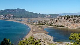
 Aerial view of İztuzu Beach | |
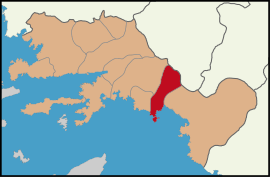
 Map showing Dalaman District in Muğla Province | |
| Coordinates: 36°46′N 28°48′E / 36.767°N 28.800°E | |
| Country | Turkey |
| Province | Muğla |
| Government | |
| • Mayor | Sezer Durmuş (CHP) |
Area | 608 km2 (235 sq mi) |
| Elevation | 15 m (49 ft) |
| Population (2022)[1] | 47,482 |
| • Density | 78/km2 (200/sq mi) |
| Time zone | UTC+3 (TRT) |
| Postal code | 48770 |
| Area code | 0252 |
| Website | www |

Dalaman is a municipality and district of Muğla Province, Turkey.[2] Its area is 608 km2,[3] and its population is 47,482 (2022).[1] It is situated on the southwestern coast of Turkey.
Dalaman Stream (Dalaman çayı) forms much of the western border of the district, where its neighbors are Köyceğiz and Ortaca districts. The town of Dalaman is located in the coastal plain, whereas the rest of the district – towards Fethiye district on the coast and towards the high mountains on the northern border to Denizli Province – is upland, dominated by the valleys of the Dalaman Stream's eastern tributaries.
Composition
[edit]There are 25 neighbourhoods in Dalaman District:[4]
- Akçataş
- Altıntaş
- Atakent
- Bezkese
- Bozbel
- Çöğmen
- Darıyeri
- Ege
- Elcik
- Gürköy
- Gürlek
- Hürriyet
- Kapıkargın
- Karacaağaç
- Karaçalı
- Kargınkürü
- Kavacık
- Kayadibi
- Kızılkaya
- Merkez
- Narlı
- Sabunlu
- Şerefler
- Söğütlüyurt
- Taşbaşı
Dalaman Airport
[edit]
Dalaman Airport serves as a gateway to the tourists who visit this part of Turkey every year, heading especially to seaside resorts to the west and east of Dalaman such as Marmaris, Fethiye, Köyceğiz, Dalyan, Ölüdeniz, Hisarönü and also Dalaman itself. Dalaman Airport (IATA: DLM, ICAO: LTBS) is small in comparison to other airports in Turkey, has parking spaces for 14 jet aircraft and is served by many operators. Turkish Airlines offer daily flights to Turkey's commercial and financial capital Istanbul. The Airport serves as a seasonal base for other airlines notably Pegasus Airlines and Free Bird Airlines. A new international airport terminal has recently been opened.
Climate
[edit]Dalaman has a hot Mediterranean climate. Summers are long and dry whilst winters are short and cool. Dalaman is a very sunny place throughout the whole of the year especially in June and July. Dalaman holds the record for one of the highest recorded air temperatures in Turkey.
| Climate data for Dalaman | |||||||||||||
|---|---|---|---|---|---|---|---|---|---|---|---|---|---|
| Month | Jan | Feb | Mar | Apr | May | Jun | Jul | Aug | Sep | Oct | Nov | Dec | Year |
| Record high °C (°F) | 25.3 (77.5) |
25.0 (77.0) |
31.0 (87.8) |
34.0 (93.2) |
38.0 (100.4) |
43.5 (110.3) |
48.5 (119.3) |
43.1 (109.6) |
42.0 (107.6) |
39.0 (102.2) |
32.8 (91.0) |
25.0 (77.0) |
48.5 (119.3) |
| Mean daily maximum °C (°F) | 15.8 (60.4) |
16.1 (61.0) |
18.5 (65.3) |
21.8 (71.2) |
26.3 (79.3) |
31.5 (88.7) |
33.9 (93.0) |
33.9 (93.0) |
31.1 (88.0) |
26.7 (80.1) |
21.3 (70.3) |
17.0 (62.6) |
24.5 (76.1) |
| Mean daily minimum °C (°F) | 5.6 (42.1) |
5.8 (42.4) |
7.0 (44.6) |
9.6 (49.3) |
13.5 (56.3) |
17.8 (64.0) |
20.7 (69.3) |
20.6 (69.1) |
17.2 (63.0) |
13.3 (55.9) |
9.4 (48.9) |
6.9 (44.4) |
12.3 (54.1) |
| Record low °C (°F) | −4.0 (24.8) |
−5.3 (22.5) |
−1.3 (29.7) |
0.0 (32.0) |
6.1 (43.0) |
9.7 (49.5) |
13.0 (55.4) |
14.0 (57.2) |
7.8 (46.0) |
4.2 (39.6) |
−1.5 (29.3) |
−1.3 (29.7) |
−5.3 (22.5) |
| Average precipitation mm (inches) | 191.2 (7.53) |
147.5 (5.81) |
91.0 (3.58) |
51.6 (2.03) |
25.1 (0.99) |
8.0 (0.31) |
2.8 (0.11) |
1.9 (0.07) |
20.4 (0.80) |
70.7 (2.78) |
159.6 (6.28) |
211.4 (8.32) |
981.2 (38.61) |
| Average rainy days | 12.2 | 10.8 | 9.0 | 7.4 | 4.3 | 2.2 | 1.4 | 1.5 | 2.1 | 5.0 | 8.8 | 12.1 | 76.8 |
| Average relative humidity (%) | 64 | 63 | 64 | 66 | 66 | 57 | 57 | 59 | 56 | 61 | 66 | 67 | 62 |
| Mean monthly sunshine hours | 158.1 | 156.8 | 213.9 | 237 | 300.7 | 342 | 365.8 | 347.2 | 300 | 244.9 | 183 | 151.9 | 3,001.3 |
| Source 1: Devlet Meteoroloji İşleri Genel Müdürlüğü [5] | |||||||||||||
| Source 2: Weather2 [6] | |||||||||||||
Education
[edit]There are five kindergartens, 13 primary schools, ten secondary schools, five high schools, one public education center, and one vocational training center affiliated with the Ministry of National Education in the district.[7]
References
[edit]- ^ a b "Address-based population registration system (ADNKS) results dated 31 December 2022, Favorite Reports" (XLS). TÜİK. Retrieved 19 September 2023.
- ^ Büyükşehir İlçe Belediyesi, Turkey Civil Administration Departments Inventory. Retrieved 19 September 2023.
- ^ "İl ve İlçe Yüz ölçümleri". General Directorate of Mapping. Retrieved 19 September 2023.
- ^ Mahalle, Turkey Civil Administration Departments Inventory. Retrieved 19 September 2023.
- ^ "Dalaman". Archived from the original on 2011-10-16. Retrieved 2011-03-19.
- ^ "January Climate History of Çeşme". 13 January 2023.
- ^ "Schools and Other Institutions". meb.gov.tr. Retrieved May 2, 2024.


