Kothagudem: Difference between revisions
Citation bot (talk | contribs) Add: title. Changed bare reference to CS1/2. | Use this bot. Report bugs. | Suggested by Thistheyear2023 | #UCB_webform |
m Added 2 {{Bare URL inline}} tag(s) using a script. For other recently-tagged pages with bare URLs, see Category:Articles with bare URLs for citations from August 2024 |
||
| (3 intermediate revisions by 3 users not shown) | |||
| Line 5: | Line 5: | ||
<!-- See [[Wikipedia:WikiProject Indian cities]] for details -->{{Infobox settlement |
<!-- See [[Wikipedia:WikiProject Indian cities]] for details -->{{Infobox settlement |
||
| name = Kothagudem |
| name = Kothagudem |
||
| other_name = <!-- Please do not add any Indic script in this infobox, per WP:INDICSCRIPT policy. --> |
| other_name = <!-- Please do not add any Indic script in this infobox, per WP:INDICSCRIPT policy. --> |
||
| settlement_type = [[City]] |
| settlement_type = [[City]] |
||
| Line 30: | Line 30: | ||
| governing_body = |
| governing_body = |
||
| leader_title = Member of Legislative Assembly |
| leader_title = Member of Legislative Assembly |
||
| leader_name = |
| leader_name = Kunamneni Sambasiva Rao |
||
| unit_pref = Metric |
| unit_pref = Metric |
||
| area_footnotes = <ref name="civicbody">{{cite web|title=Urban Local Body Information|url=http://www.dtcp.telangana.gov.in/ULBs-List-68.pdf|website=Directorate of Town and Country Planning|publisher=Government of Telangana|access-date=28 June 2016|url-status=dead|archive-url=https://web.archive.org/web/20160615135503/http://dtcp.telangana.gov.in/ULBs-List-68.pdf|archive-date=15 June 2016}}</ref> |
| area_footnotes = <ref name="civicbody">{{cite web|title=Urban Local Body Information|url=http://www.dtcp.telangana.gov.in/ULBs-List-68.pdf|website=Directorate of Town and Country Planning|publisher=Government of Telangana|access-date=28 June 2016|url-status=dead|archive-url=https://web.archive.org/web/20160615135503/http://dtcp.telangana.gov.in/ULBs-List-68.pdf|archive-date=15 June 2016}}</ref> |
||
| Line 70: | Line 70: | ||
==Demographics== |
==Demographics== |
||
{{Historical Populations |
{{Historical Populations |
||
|source = <ref>https://censusindia.gov.in/census.website/data/census-tables</ref> |
|source = <ref>https://censusindia.gov.in/census.website/data/census-tables {{Bare URL inline|date=August 2024}}</ref> |
||
|1941 |9669 |
|1941 |9669 |
||
|1951|50195 |
|1951|50195 |
||
| Line 80: | Line 80: | ||
|2011|119501 |
|2011|119501 |
||
}} |
}} |
||
According to the [[2011 Census of India|2011 India Census]] the population of Kothagudem was 119,501.<ref>https://censusindia.gov.in/census.website/data/census-tables</ref> |
According to the [[2011 Census of India|2011 India Census]] the population of Kothagudem was 119,501.<ref>https://censusindia.gov.in/census.website/data/census-tables {{Bare URL inline|date=August 2024}}</ref> |
||
==Transport== |
==Transport== |
||
| Line 91: | Line 91: | ||
<!-- Add entries if it has wiki articles --> |
<!-- Add entries if it has wiki articles --> |
||
* [[University College of Engineering, Kakatiya University]] |
* [[University College of Engineering, Kakatiya University]] |
||
==Climate== |
|||
{{Weather box|width=auto |
{{Weather box|width=auto |
||
| location = Bhadrachallam (Kothagudem) 1981–2010, extremes 1952–2012 |
| location = Bhadrachallam (Kothagudem) 1981–2010, extremes 1952–2012 |
||
| Line 210: | Line 210: | ||
| access-date = 17 February 2020}}</ref> |
| access-date = 17 February 2020}}</ref> |
||
}} |
}} |
||
== References == |
== References == |
||
Latest revision as of 17:29, 19 August 2024
This article possibly contains original research. (July 2017) |
Kothagudem | |
|---|---|
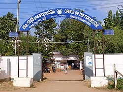
 District collectorate at Kothagudem | |
| Coordinates: 17°33′00″N 80°37′48″E / 17.550°N 80.63°E | |
| Country | |
| State | |
| District | Bhadradri Kothagudem |
| Government | |
| • Member of Legislative Assembly | Kunamneni Sambasiva Rao |
| Area | |
• Total | 32.10 km2 (12.39 sq mi) |
| Elevation | 89 m (292 ft) |
| Population (2023)[2] | |
• Total | 119,501 |
| • Rank | 19th in Telangana |
| • Density | 3,700/km2 (9,600/sq mi) |
| Languages | |
| • Official | Telugu, Urdu |
| Time zone | UTC+5:30 (IST) |
| PIN | 507 xxx |
| Telephone code | +91-8744 |
| Vehicle registration | TS 28 |
| Sex ratio | 1:1 ♂/♀ |
Kothagudem is a city in Telangana. It serves as the headquarters of the Bhadradri Kothagudem district of the Indian state of Telangana. It was a portion of large Zamindari estate known as Husanabad Shankaragiri or Palvancha Zamindari in the Nizam's Dominion. Estate name was given by Captain Glasfurd.[3][4] The Zamindar of Bhadrachalam was Zamindar of Palvancha also.[3]
Geography
[edit]Kothagudem is located at 17°33′00″N 80°37′05″E / 17.55°N 80.618°E. It has an average elevation of 89 metres (295 ft) above sea level.[5] The North of Kothagudem borders Chhattisgarh state which is approximately 120 km from the town.
Kothagudem is known for its record high temperatures during summer, often crossing 48 °C (118 °F) mark.[6]
Government and politics
[edit]Kothagudem Municipality was constituted in 1971 and is classified as a first grade municipality with 33 election wards. The jurisdiction of the civic body is spread over an area of 16.10 km2 (6.22 sq mi).[1]
Demographics
[edit]| Year | Pop. | ±% |
|---|---|---|
| 1941 | 9,669 | — |
| 1951 | 50,195 | +419.1% |
| 1961 | 69,728 | +38.9% |
| 1971 | 75,542 | +8.3% |
| 1981 | 94,894 | +25.6% |
| 1991 | 102,137 | +7.6% |
| 2001 | 105,266 | +3.1% |
| 2011 | 119,501 | +13.5% |
| Source: [7] | ||
According to the 2011 India Census the population of Kothagudem was 119,501.[8]
Transport
[edit]National Highway 30 passes through this town.
Rail
[edit]Kothagudem has a train station which is called Bhadrachalam Road railway station. It is located on the Dornakal–Manuguru line.[9]
Education
[edit]Climate
[edit]| Climate data for Bhadrachallam (Kothagudem) 1981–2010, extremes 1952–2012 | |||||||||||||
|---|---|---|---|---|---|---|---|---|---|---|---|---|---|
| Month | Jan | Feb | Mar | Apr | May | Jun | Jul | Aug | Sep | Oct | Nov | Dec | Year |
| Record high °C (°F) | 37.2 (99.0) |
40.6 (105.1) |
42.8 (109.0) |
46.4 (115.5) |
48.6 (119.5) |
47.5 (117.5) |
40.8 (105.4) |
38.2 (100.8) |
38.6 (101.5) |
38.2 (100.8) |
36.0 (96.8) |
35.2 (95.4) |
48.6 (119.5) |
| Mean daily maximum °C (°F) | 30.8 (87.4) |
33.8 (92.8) |
37.2 (99.0) |
39.3 (102.7) |
40.9 (105.6) |
36.8 (98.2) |
32.7 (90.9) |
31.6 (88.9) |
32.8 (91.0) |
32.6 (90.7) |
31.3 (88.3) |
30.3 (86.5) |
34.2 (93.6) |
| Mean daily minimum °C (°F) | 17.0 (62.6) |
19.9 (67.8) |
22.8 (73.0) |
25.5 (77.9) |
27.4 (81.3) |
26.5 (79.7) |
24.6 (76.3) |
24.4 (75.9) |
24.5 (76.1) |
22.9 (73.2) |
19.3 (66.7) |
16.9 (62.4) |
22.6 (72.7) |
| Record low °C (°F) | 8.4 (47.1) |
11.6 (52.9) |
14.0 (57.2) |
17.0 (62.6) |
18.6 (65.5) |
19.4 (66.9) |
20.0 (68.0) |
19.8 (67.6) |
19.6 (67.3) |
14.0 (57.2) |
10.0 (50.0) |
8.4 (47.1) |
8.4 (47.1) |
| Average rainfall mm (inches) | 5.8 (0.23) |
6.2 (0.24) |
11.2 (0.44) |
31.5 (1.24) |
41.2 (1.62) |
116.4 (4.58) |
293.7 (11.56) |
292.9 (11.53) |
156.6 (6.17) |
82.9 (3.26) |
19.4 (0.76) |
3.0 (0.12) |
1,060.8 (41.76) |
| Average rainy days | 0.5 | 0.4 | 0.8 | 1.5 | 2.6 | 7.0 | 13.3 | 13.0 | 8.0 | 4.1 | 1.5 | 0.3 | 52.8 |
| Average relative humidity (%) (at 17:30 IST) | 56 | 47 | 44 | 42 | 39 | 56 | 74 | 77 | 77 | 74 | 68 | 63 | 60 |
| Source: India Meteorological Department[10][11] | |||||||||||||
References
[edit]- ^ a b "Urban Local Body Information" (PDF). Directorate of Town and Country Planning. Government of Telangana. Archived from the original (PDF) on 15 June 2016. Retrieved 28 June 2016.
- ^ "Research Data". Census of India. pp. 14–15, 40. Retrieved 2 January 2016.
- ^ a b Gazetter, Godavari (1915). Madras District Gazetteers Godavari District Gazetteer. Madras: Asian Educational Services. p. 259. ISBN 81-206-1461-5.
- ^ Andhra Pradesh, Census (1968). ANDHRA PRADESH 1961 CENSUS - DISTRICT CENSUS HAND BOOK - KHAMMAM DISTRICT. Hyderabad: Government of Andhra Pradesh. pp. 96–97.
- ^ "Maps, Weather, and Airports for Kottagudem, India". www.fallingrain.com.
- ^ "The Hindu article about Kothagudem". The Hindu.[dead link]
- ^ https://censusindia.gov.in/census.website/data/census-tables [bare URL]
- ^ https://censusindia.gov.in/census.website/data/census-tables [bare URL]
- ^ "Bhadrachalam Road Railway Station Forum/Discussion - Railway Enquiry".
- ^ "Station: Bhadrachallam (Kothagudem) Climatological Table 1981–2010" (PDF). Climatological Normals 1981–2010. India Meteorological Department. January 2015. pp. 125–126. Archived from the original (PDF) on 5 February 2020. Retrieved 17 February 2020.
- ^ "Extremes of Temperature & Rainfall for Indian Stations (Up to 2012)" (PDF). India Meteorological Department. December 2016. p. M11. Archived from the original (PDF) on 5 February 2020. Retrieved 17 February 2020.


